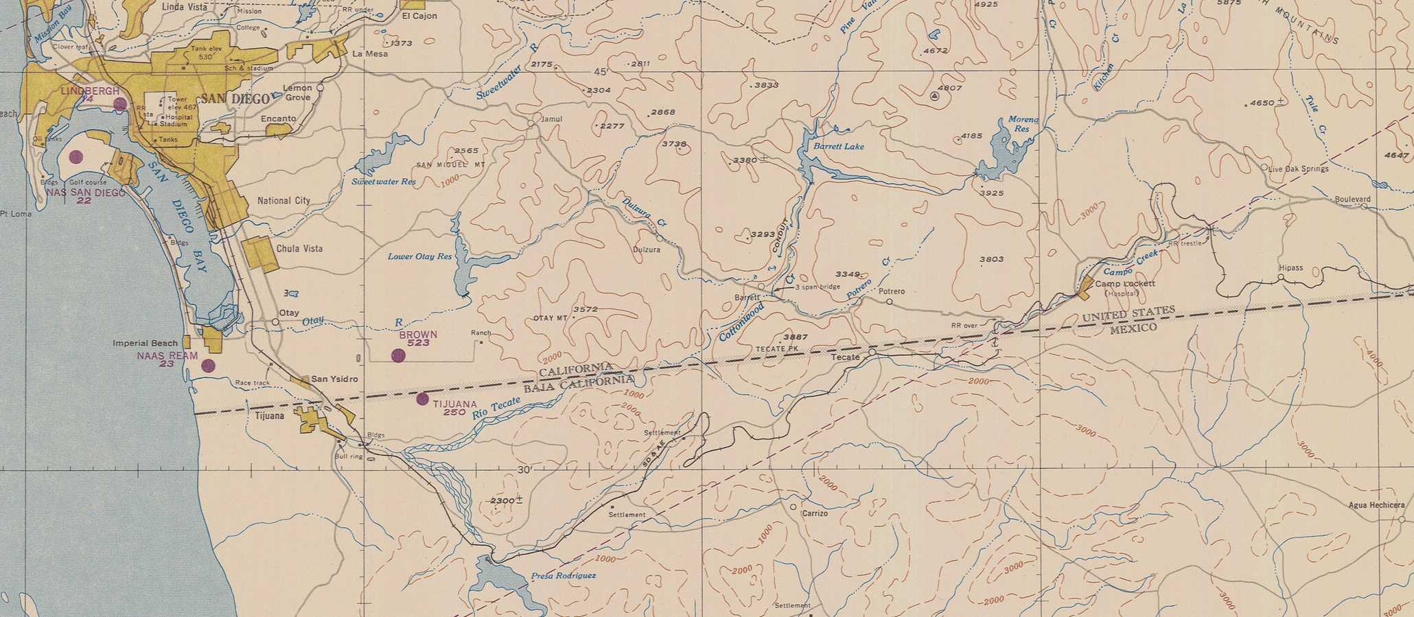
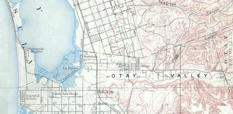
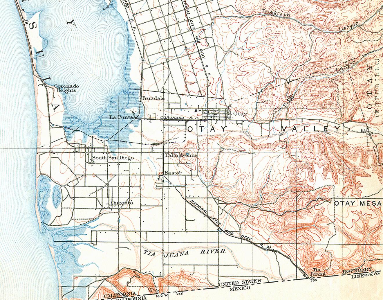
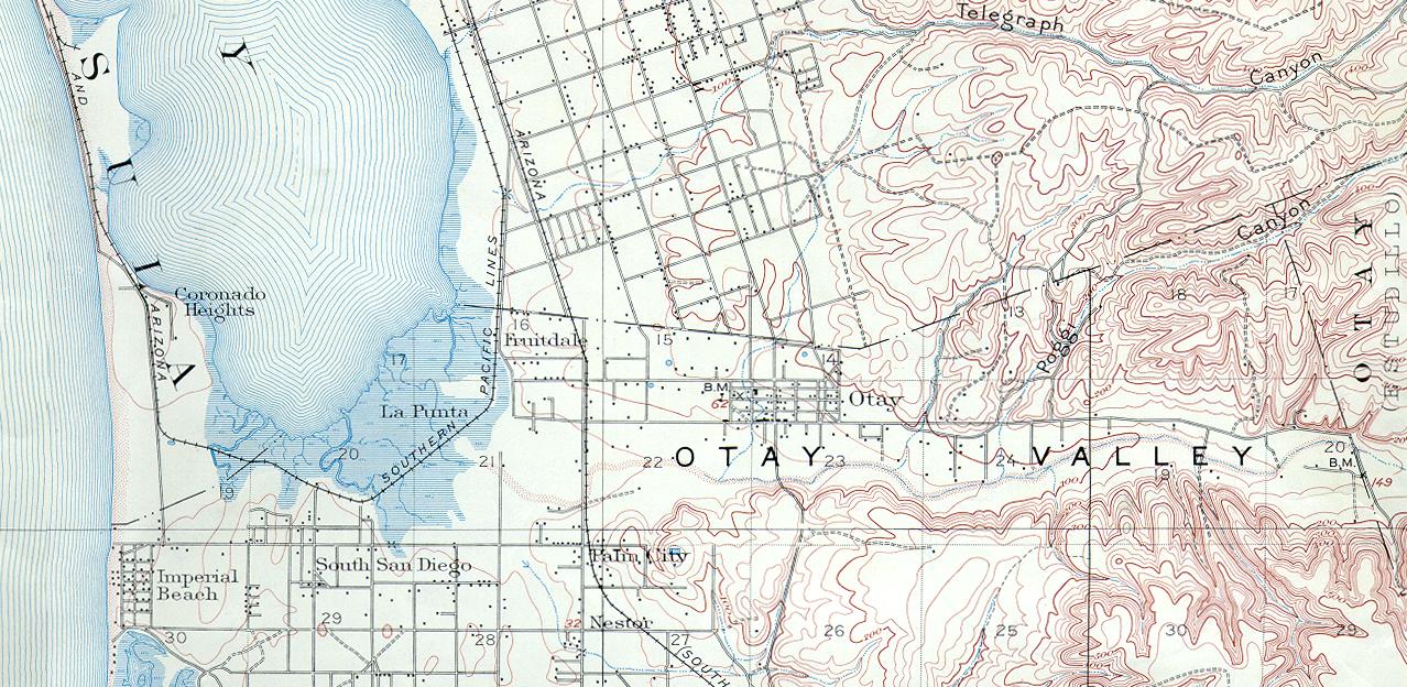
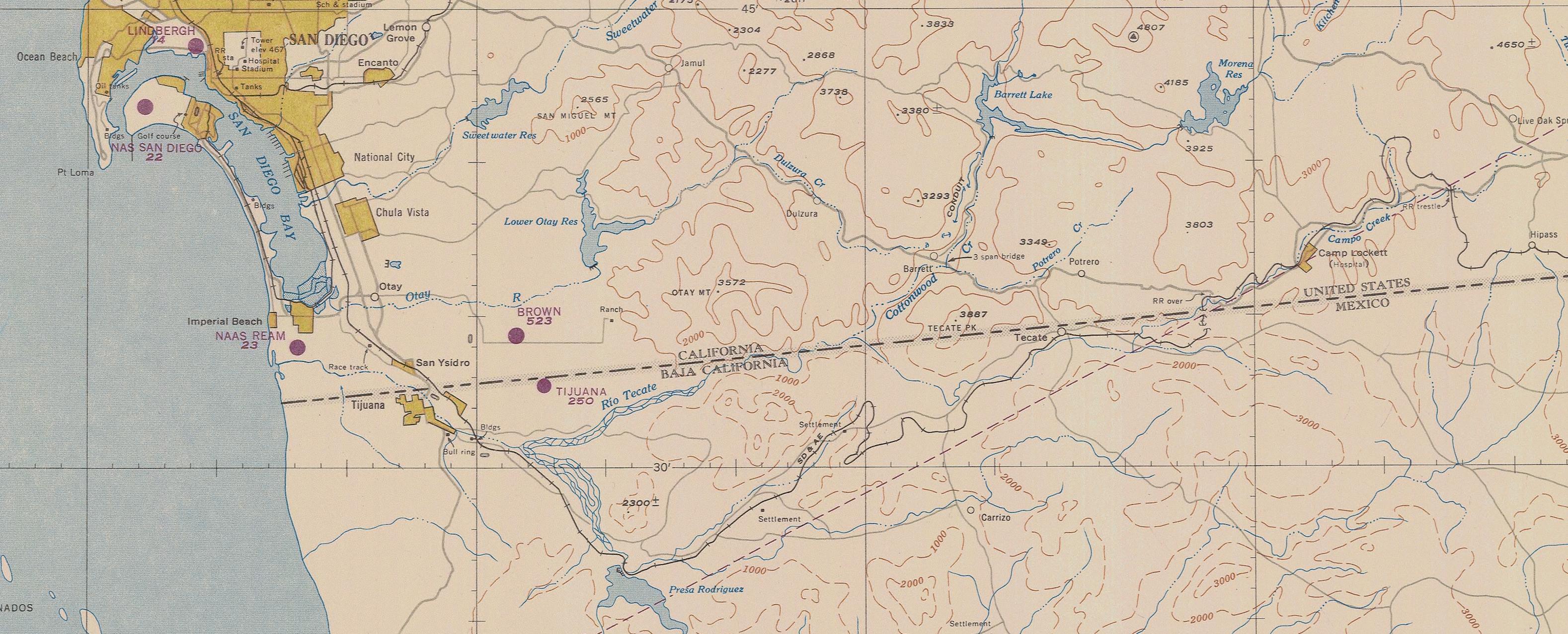
Otay Valley
 The Otay Valley begins at the Lower Otay Dam and reservoir
|
Otay Valley and the surrounding mesa were originally under ocean water several million years ago, along with most of San Diego County south of Mission Valley and west of College Grove. Pliocene fossils found on Otay Ranch include a baleen whale, clams, mollusks, and an extinct walrus. As the Pacific Plate moved under the North American Plate, the shoreline was pushed up, rising from San Diego Bay to a low coastal mountain range 5000 feet above sea level. The water flow from these mountains to the coast carved five major river valleys into the southern mesa. The Chollas Valley met the bay at Indian Point (Barrio Logan), the Sweetwater Valley ran through National City, Telegraph Canyon to Chula Vista, Otay Valley to La Punta at the southern end of the bay, and the Tia Juana Valley from northern Baja California to the Pacific Ocean below the bay. Kumeyaay villages occupied these valleys long before the arrival of Cabrillo in 1542, of Vizcaino in 1602, of Captain Juan Perez who established the first Spanish base at Dead Man's Point April 29, 1769, and of Father Serra who crossed the Otay Valley on his land expedition from Baja Mexico to the second Spanish base at the foot of Presidio hill July 1, 1769.
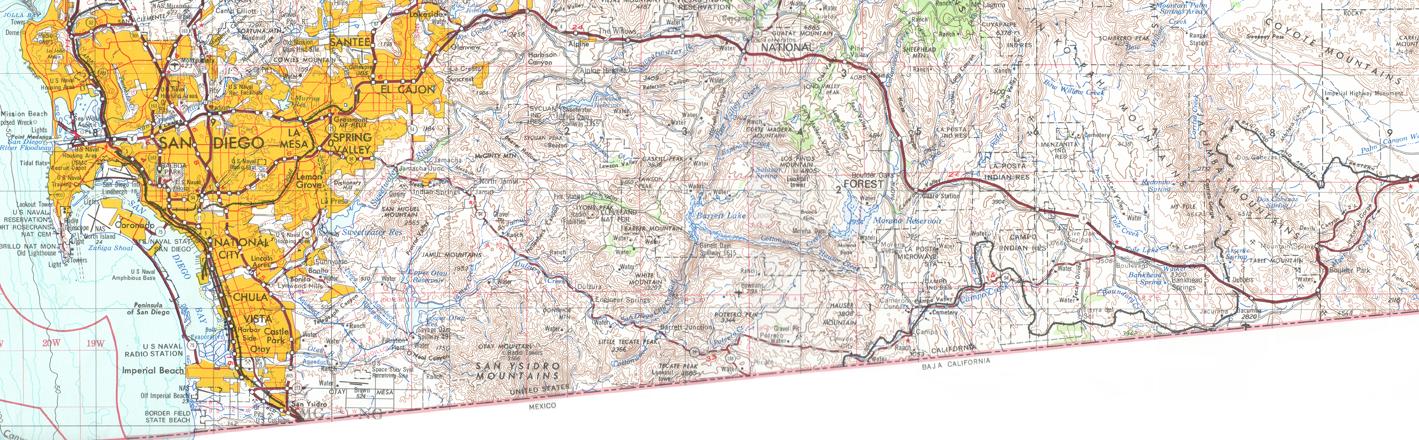
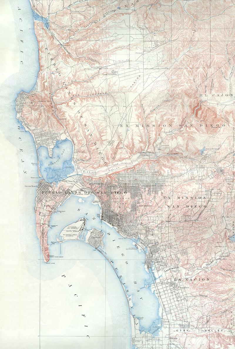
 San Diego south 1950 map from NOAA
|
The San Dieguito cultural group lived in the San Diego region as early as 13,000 years ago. They used tools called manos and metates to press nuts and berries and seeds from the oak woodlands into a paste for food, and have been called the "Scraper Makers." They were followed by the La Jollan cultural group 7500-3000 BC. The Kumeyaay were a Yuman-speaking cultural group that came to the area about 3000 BC. They were nomadic, hunting and gathering food, living in small villages called rancherias located near river valleys, using the water to leach the tannic acid out of acorns that were then pounded into a paste used for baking. They also gathered agave in the spring for food. "Otai" is the Kumeyaay word for brush, and the Otais were southern Kumeyaay living on what became known as Otay Mesa. Southern Kumeyaay rancherias existed at La Punta, at Milijo in the Tijuana valley ("tijuana" is the Kumeyaay word for "by the sea"), and at San Pablo south of the Tijuana River where the Kumeyaay encountered Father Serra when his land expedition entered Alta California at Smuggler's Gulch in 1769. A second Spanish land expedition led by Father Juan Crespi met the Kumeyaay at the Sancti Spiritus camp north of the Tijuana valley near Palm Avenue in present-day Nestor. In 1825 the mission priests visited the Kumeyaay village of Otai in the canyon below the Otay Mountain.
1782 - The expediton of Juan Pantoja y Arriaga in the frigate Princesa was the first to chart all of San Diego bay, naming the "rancheria de la Punta" for the Kumeyaay village at the mouth of the Otay River at the southern end of the bay, and the "rancheria de los Choyas" for the village at the mouth of Chollas Creek. Josef Velásquez drew the first map of the interior for the 1782 expedition of Pedro Fages from the Colorado, and noted on his map the Sweetwater river that he called the "Arroyo de la caballada."
1829 - Gov. Echeandía granted to María Magdalena Estudillo the Otay Rancho of 6,657.98 acres, and the adjoining Janal Rancho of one square league (4,439 acres) to her brother Jose Antonio Estudillo. These were among the earliest of the 29 land grants in San Diego, starting with Rancho Penasquitos to Francisco Ruiz in 1823, that marked the rise of the Californios following the end of Spanish rule in 1821 and the shift of population away from the presidios. The ranchos raised cattle for the hide trade that brought an growing number of foreigners to San Diego, such as Henry Fitch and Richard Henry Dana. The Estudillos were absentee ranchers, living in the pueblo of Old Town San Diego. Santiago Arguello was granted the Tia Juana Rancho below the future international boundary in 1829. His son, Santiago Emilio Arguello, received Rancho Milijo above the boundary from Gov. Figueroa in 1833, a vast area of 30 square miles from the ocean to the Tia Juana Mountains including the valleys and mesas of the Otay and Tia Juana rivers. The Arguellos built a U-shaped adobe on the bluffs above La Punta at the southern end of the bay, on the road from San Diego to Mexico, and was for many years the only dwelling in all south San Diego. Due to the prominence of this home, the Arguello lands in the south bay would be called Rancho La Punta.
1845 - Gov. Pio Pico granted to his brother-in-law John Forster the Rancho de la Nacion of 26,631 acres in the south bay that was originally called Rancho del Rey when it was set aside in 1795 for the use of the Spanish Presidio. This was one of the last private land grants by the Mexican governors of California. Within one year, as required by the grant, Forster built an adobe house where Rohr Park is today on the north side of the Sweetwater River. Henry Fitch drew a map defining the boundaries of the pueblo of San Diego as the area south of Rancho Penasquitos, north of Rancho de la Nacion, and west of the mission lands that were granted to Santiago Arguello in 1846.
1848 - Treaty of Guadalupe Hidalgo ended the Mexican-American War, set the international boundary one league (2.597 miles) south of the bay.
1850 - San Diego County was created and California became a state. The Estudillos kept title to the Otay and Janal ranches (patent confirmed 1872), but Santiago Arguello lost his title to the La Punta ranch and to the Tia Juana ranch north of the border (much of it had been abandoned since 1837 due to Indian raids). Captain Henry S. Burton and his new wife María Ampara Ruiz, granddaughter of pioneer soldier Juan Maria Ruiz, bought the Jamul ranch in 1856. John Forster sold the National Ranch in 1854 to the Frenchman F. A. L. Pioche of San Francisco and moved to San Juan Capistrano from 1854 to 1864, then to the Santa Margarita y las Flores ranch.
1862 - After the death of Santiago Arguello, his wife Pilar Ortega Arguello lost the northern Tia Juana ranch, and was challenged by some of her 22 children for ownership of the 26,000 acres of the southern Tia Juana ranch. Before her death in 1878, she sold 13,000 acres of the ranch to her son Ignacio. The Arguellos also kept the Mission ranch of 58,875 acres that was opened to settlement after 1885. His son Santiago E. Arguello kept ownership of the family home at La Punta where he lived with his wife Guadalupe Estudillo, grantee of Rancho Janal, until his death in 1857. Guadalupe continued to appeal for ownership of the rancho until 1873, but more than 75 squatter farmers had settled on the rancho and fought against the Arguello appeals, and in 1873 won their case and were allowed to keep their claims. Maria Antonia Arguello, the daughter of Guadalupe and Santiago E. Arguello, married Captain Alfred H. Wilcox and kept ownership of a ranch around the La Punta homestead, known as La Punta gardens. In 1871 Wilcox leased 82-acres fo his ranch to Henry von Poser who built a resort and picnic area that became known as Fruitlands.
1865 - The small town of Ti Juana began in 1865 with a general store of George Washington Barber on the American bank of the Tia Juana river where it crossed the boundary. William Lane from Wales bought 160 acres at this location in 1866. The Memphis and El Paso Railroad in 1871 began grading for a route to Yuma across Lane's townsite. A Mexican customs post was established in 1874 at this border crossing of the ranch to tax the international trade.
1868 - Frank, Warren and Levi Kimball bought the National ranch for $30,000 and laid out the new town of National City along the bay in the northwest corner of the ranch. The Kimball wharf was built in 1871 at 11th Ave. (Grafield) and 17th St., 1800 feet long, 24 feet wide with a platform 75 feet wide, with room for five ships. The first ship to use the wharf was the Orizaba on Sept. 26, 1871. 1000 feet of the wharf collapsed in 1877 and it was dismantled and no longer used.
1869 - San Diego County Surveyor James Pascoe designed a stagecoach route for operator John Capron from San Diego to Yuma that ran through the Otay Valley, across the Jamul ranch, then along the Dulzura Creek to Campo (as SR 94 does today), then through the Milquatay Valley to Jacumba and the Mountain Springs pass. This was one of the main land routes east to Yuma from San Diego until old Highway 80 was built in the 1917. Another route to Yuma was found for a military telegraph. On May 28, 1869, the U. S. Army announced a plan for a telegraph line from Fort Yuma to San Diego. The schooner Johanne arrived August 26, 1873, with poles and wire for the military telegraph line from National City. Capt. William E. Dove began construction of the telegraph Oct. 4, 1873, using a valley south of the Sweetwater Valley to reach Jamul and connected Yuma by November. Frank Kimball named the route out of National City the "Telegraph Road" and had it cleared of brush and widened to 12 feet.
1871 - Hiram Murray Higgins planted the first citrus orchard in the Sweetwater Valley in 1871, on 76 acres purchased from the Kimball brothers in what is now the Bonita Woods area, building redwood-log water pipes, steam pumps, and windmills to construct the first irrigation system in the valley that brought water from the Sweetwater River to his Bonnie Brae ranch. By 1877, he had planted 2000 citrus trees of various kinds.
1873 - After the death of Maria Victoria Estudillo, Victoria Dominguez kept ownership of the Otay and Janal ranches.
1876 - J. C. Frisbie of Chicago laid out the 246-acre tract of Sunnyside in the Sweetwater Valley.
1875 - After the death of Captain Burton, his wife and son were granted the patent to the 8,926-acre Jamul ranch. María Burton and her son Henry Burton founded the Jamul Portland Cement Manufacturing Company in 1889 but went bankrupt in 1892.
1878 - The Daneri family established a ranch and winery in the Otay river valley. Emmanuel Daneri immigrated from Italy and settled in Old Town San Diego in 1870. He purchased 900 acres in the Otay Valley west of the Otay Ranch to grow grapes and built a winery. Emmanuel was helped by his brother Jim who owned a liquor store in Old Town, and by cousins Joe, Frank, and Jack who moved from San Francisco. Emmanuel's sister married into the Dini family in National City. John Daneri, Emmanuel's son, married Aurelia de Bincenzi and took over the family winery until it was wiped out by the 1916 flood.
1883 - John Montgomery made the world's first controlled flight August 28 with a fixed curved-wing glider, flying 600 feet from the top of a hill on Otay Mesa near La Punta.
1885 - The Santa Fe Railroad began passenger service to San Diego, setting off the great "Boom of the Eighties." Frank Kimball of National City was responsible for the deal with the Atchison, Topeka & Santa Fe railroad in 1880, creating the California Southern railroad, offering to the railroad 10,000 acres of land in National City for a railroad terminus.
1886 - The San Diego Land and Town Company, a subsidiary of the Santa Fe railroad, began construction of the Sweetwater dam to promote the sale of land in new subdivisions of National City and Chula Vista. It also built the National City and Otay Railway that ran along the bay from Fifth and L in San Diego through National City and Chula Vista to the border. By 1888 there were 30 miles of track finished, starting at Fifth and L in San Diego, continuing to the National City Depot at Sixth Ave and 24th Street. The Kimballs had started the first horse-drawn streetcar system in National City, and from this Depot, the Seventh Avenue streetcar went east to Paradise Valley (named in 1869 when sea captain Crain arrived after a voyage around the Horn and called it "paradise"). Dr. Anna M. Longahore Potts built the large Paradise Valley Sanitorium and Hospital. At the Sweetwater Junction between National City and Chula Vista, a branch line turned east through the Sweetwater Valley to La Presa. The main line continued down the bay to Fruitlands and Otay and Oneonta and Tia Juana. A stagecoach connected the American town of Tia Juana with the Tia Juana Hot Springs on the old Arguello rancho across the border. The Coronado Belt Line ran trains on this route around the bay up the Silver Strand to the Hotel Del Coronado that opened February 1, 1888.
1887 - New towns appeared in the south bay area during the boom. The town of Otay located east of old La Punta was the largest of the boom towns. It featured the Otay Watch factory financed by Frank Kimball and the Otay Press weekly newspaper published in Otay by A. J. Jenkins until it moved to Chula Vista in July 1900. The Bonita townsite was developed in 1887 by Henry Cooper in the Sweetwater Valley. In 1890 the Sweetwater Fruit Company bought Cooper's Bonita Ranch, planted orchards, and offered five-acre lots for sale. Captain Fitzhugh developed La Presa, and in 1888 began a burro train to the top of Mt. San Miguel. By 1890, the trip up the mountain was promoted by A. H. Isham and H. L. Story who also sought to built the Proctor Memorial Observatory on the mountain with money from Mrs. Richard A. Proctor. South San Diego Beach was formed in June by R. R. Morrison at the southern end of the bay, and the name was changed to Imperial Beach by promoter George Chaffey who sought to attract settlers from the Imperial Valley. Oneonta was located below Imperial Beach near the border, a 450-acre tract developed by the Oneonta Land, Water and Town Company. The first settlers in 1886 from Oneonta, New York, gave the name to the town. it planned to become a major resort, with the Oneonta Hotel and footbridges across the marshlands to the Oneonta Beach and bath house. The border towns of Tia Juana (on the American side) and Tijuana (on the Mexican side) began to flourish during this boom era. Merchants such as Joseph Messenger, Alejandro Savín and Felipe Crosthwaite developed the tourist trade by offering horse races and bullfights in the Mexican town. An agreement of July 12, 1889, ended the land dispute among the Arguellos, and Antonio Arguello sold land for the subdivision of Zaragoza de Tijuana. In the 1920s Alberto Arguello leased the Agua Caliente hot springs to an investor group headed by Baja Gov. Rodriguez, who opened the great Agua Caliente Resort in 1928 with a casino, hotel, and spa, soon joined by a race track, golf course, aviary, radio station, and airport.
1888 - The Sweetwater dam was completed April 7, at 90 feet the highest dam in the U.S. at that time, and 340 feet long at the top. It formally opened with a Water Festival in National City on April 19.
1889 - The boom ended with the move of the Santa Fe railroad operations center to San Bernardino. Transcontinental trains would no longer use the National City terminus. Babcock and Story sold their interests to John D. Spreckels, including the La Punta salt works where Babcock used dynamite to enlarge the fresh water spring but instead caused the spring to disappear. The sale also included the well on Otay Mesa that piped fresh water to the Hotel del Coronado, and the mines built by Frank Kimball on the Janal ranch. The Otay Valley was an important grazing area for sheep driven up from Mexico to graze during the winter. In the late 1880s, 30,000 sheep came yearly to the Valley. Drivers included Hugh O'Neill who drove 16,000, and Nieto Echenique who drove 20,000 into the Otay in 1889. The sheep remained through the spring lambing and wool shearing seasons. In March and April each year, 200 tons of wool were clipped.
1890 - The Otay Watch Factory opened Feb. 6 in a three-story brick building located on the southeast corner of Tremont and Fresno Streets in Otay, but closed 247 days later, Oct. 13; the building was razed in 1934. Despite the failure of the railroad and watch factory, the small farm community on Otay Mesa created by the boom of the 1880's continued to grow with above average rainfall. W. M. Tibbits was the first owner in 1886 of what later became the Kuebler Ranch on Otay Mesa. Alta School was founded in January 1886, and St. John's Lutheran Church was built 1889. A store and blackmith shop and the Siempre Viva post office were built on the J. Harvey McCarthy farm near Alta School. The Mount Tecarte Land and Water Company was incorporated March 7, 1888. D. O. McCarthy was a local rancher and stockholder in the company. But the company failed to deliver water at a reasonable price to local ranches. Some residents formed the Otay Irrigation District in 1891 at J. Harvey McCarthy's General Store in Siempre Viva, but the District failed by 1900. James McCool harvested 300 tons of hay, William Lohman grew 80 acres of barley, and James Coley planted 400 acres with wheat and barley. The harvested grain was carried by wagon to the Otay station of the National City and Otay Railroad that loaded 2 or 3 cars of grain per week from June 1889 to February 1890. By October 1890, the mesa had exported 3000 tons of hay. By 1899, children from 27 households were attending Alta School. However, the weather turned dry after 1897, and only 9 families were enrolled in the school by 1910. The Piper family was one of the few that survived the drought years. Charles Piper immigrated from Germany in 1867 and lived in Nebraska with his wife Herminia and two daughters Margarita and Johaima. In 1887 they filed a timber claim for 160 acres on Otay Mesa. A third daughter Emma was born 1889 and a son Henry C. was born 1892. The Pipers were on the Alta school board and were trustees of St. John's church. Henry C. Piper married Rebecca Lures from the farm of Betty and Henry Schott, her aunt and uncle who lived on the northeast corner of the mesa. The two sons of Henry and Rebecca were Herman and Henry Piper, Jr., who took over the farm in 1936 and continued producing grain during World War II and into the 1960s.
1891 - The great February storm filled the valleys with water in southern California, widening the Colorado River to 20 miles, destroying the city of Yuma. It washed away 25 of the 40 buildings in Tia Juana north of the border, causing residents to rebuild on higher ground in the Mexican city of Tijuana and what would become the American city of San Ysidro.
1893 - William Carson attempted to build the San Diego and Arizona Railroad to Phoenix over the southern wagon road to Yuma, but completed only a few miles of track in Otay Valley from the salt works to a place called Phoenix Park near the Daneri vineyards.
1894 - Elisha Spurr Babcock, Jr. and his wife purchased the Janal Rancho from the Kimballs, and gained control of the Mount Tecarte Land and Water Company.
1896 - Babcock and Spreckels merged their Mount Tecarte Land and Water Company and Otay Water Company interests to form the Southern California Mountain Water Company and began construction of the Morena Dam on the Cottonwood-Otay river system that would become an important supply of water to the city of San Diego.
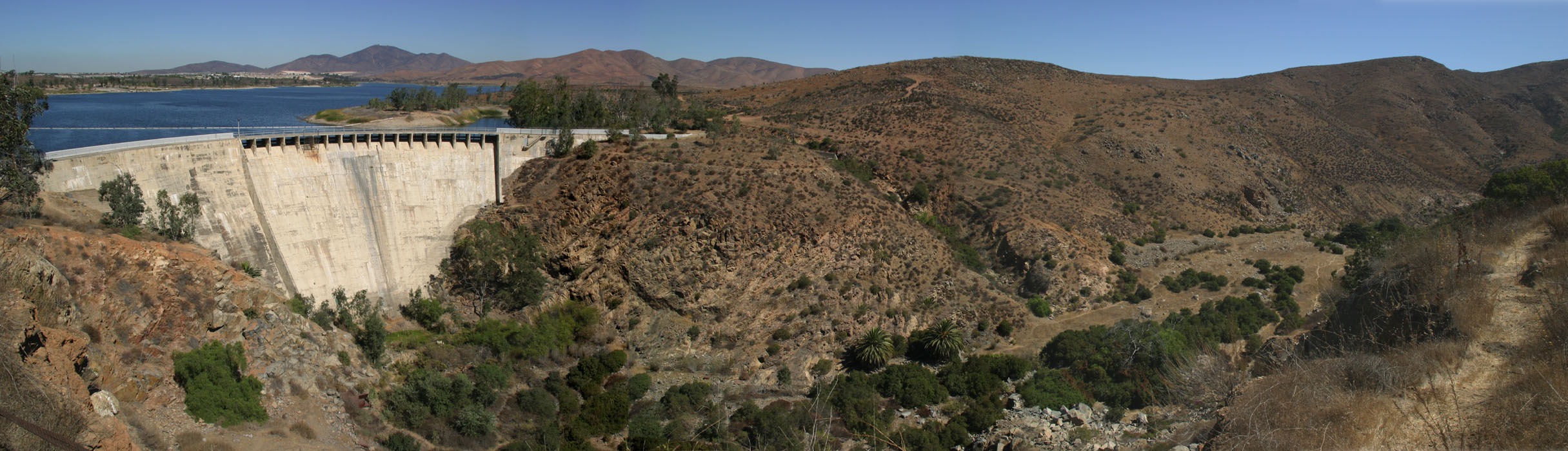
1897 - The Southern California Mountain Water Company completed construction of the Lower Otay Dam.
1900 - The San Diego Land and Town Company filed a subdivision map for part of the Otay Rancho that it had purchased in 1886 from Mathew Sherman. However, the prolonged drought prevented any building on the mesa, and the company was reorganized in 1902 into three parts: The Sweetwater Water Company managed water; the San Diego Fruit Company managed orchards; the San Diego Land Company managed properties.
1901 - The Klauber Wangenheim Company purchased the La Punta Salt Works at the south end of the bay that had been founded in 1871 by Shaffer and Stone as the Otay Salt Works, and owned by E. E. and J. E. Shaffer since 1888. In 1902 the Western Salt Company was founded by Graham Babcock. Graham was the son of Elisha Spurr Babcock, Jr. who built the Hotel del Coronado in 1888. After the death of Graham, Elisha bought the company in 1911 and expanded its operations. The flood of 1916 almost wiped out the company, but L. M. Drown of the Merchants financed the rebuilding of the salt works, and became profitable by 1918 under Frank Riehle. The bank foreclosed on the property in 1922 after the failure of Elisha Babcock's La Jolla Railway that was supported by loans on the salt works property. Henry G. Fenton, a contractor who had worked for E. S. Babcock, bought the company in 1922, paid its loans, and under the management of Neil B. Ditterhaver the company again became successful.
1906 - The San Diego and Arizona Eastern Railway began construction of a railroad line from San Diego to Yuma, finally completed in 1919, and causing population growth in the South Bay.
1907 - A Mexican federal decree permitted gambling in Baja California, and gambling establishments began to appear on the border, and the American John E. Russell built a greyhound racing track in Tijuana. After the "Battle of Tijuana" in the 1911 civil war, federal troops retook Tijuana and shut down the gambling halls. Howsever, in 1915 they reopened and Americans invested in the construction of the Lower California Jockey Club race track that attracted a new rush of tourism to the border.
1908 - Little Landers was the name of a short-lived cooperative farming colony founded by William E. Smythe in the Tia Juana Valley. Smythe was the publisher of the San Francisco magazine "Little Lands in America" that promoted a back-to-the soil movement where everyone owned their own small one-acre plot of land. Their slogan was "A little land and a living..." Smythe led a company that purchased for $15,000 the remnants of the township of Tia Juana that had been wiped out by the flood of 1891. The Little Landers tract of 550 acres included 150 in the Tia Juana Valley bottom, and 400 on the slope of the north hill. The experimental community began to decline after the Hatfield flood destroyed property and crops of 100 families of the colony on Jan. 18, 1916. During the prohibition 1920's it became a border community for employees of the racetracks and bars in the boom town of Tijuana, and evolved into the community of San Ysidro, named in honor of the Spanish patron saint of farming.
1911 - Chula Vista was incorporated as a city on Oct. 17, but the area remained rural until World War II, featuring thousands of acres of lemon trees.
1913 - The Hercules Powder Company was created Jan. 1, 1913, as a result of a federal antitrust lawsuit against Du Pont. During WWI Hercules produced 20,000 tons of smokeless cordite for the British, made from kelp. Hercules built a new plant in Chula Vista beginning in Feb. 1916, including 156 redwood digestive tanks to ferment the kelp to make acetone and potash. Hercules built three giant kelp harvesters in 1916 to cut the sea plant in large quantities. In 1920 the plant was dismantled.
1916 - Charles Hatfield set up his tower at the Morena Reservoir and reported rain beginning January 5, 1916. The rain became heavy January 10 through January 18. Old Town was flooded as the San Diego River overflowed its bank. Highways were closed, bridges washed out and the Santa Fe Railroad stopped service. The Little Landers colony in San Ysidro was destroyed. Rain was intermittent after January 18 until a powerful storm January 25 caused the water level in the Sweetwater reservoir to rise 40 inches above the top of the dam and a 90-foot section of the north abutement to break away, resulting in a flood of the entire Sweetwater Valley. The NC&O railroad tracks washed away, and the railroad was abandoned, ending light rail service in the south bay. Most of the 21 killed in the Sweetwater flood were Chinese living near their gardens in the valley bottom. The storm washed away the Lower Otay Dam and inundated the Otay Valley with 13 billion gallons of water that rushed seven miles to the bay, washing away homes and farms and killing 14 people.
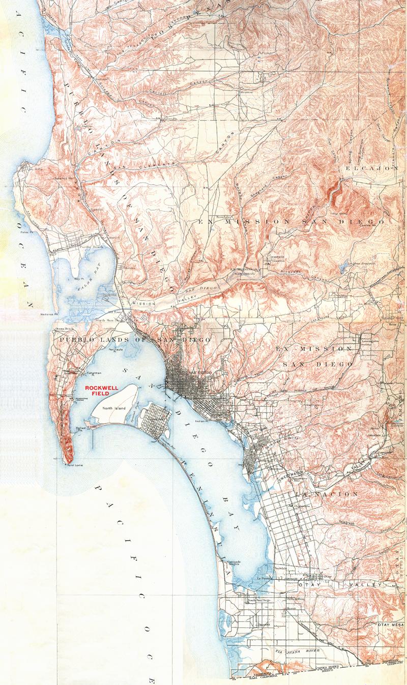
1918 - When the U. S. entered World War I, the Army in San Diego took over North Island and built Camp Kearny. It also established Ream Field in Imperial Beach and an airfield at Otay Mesa, named East Field in honor of Major Killian East, who had been killed in an automobile accident near Mitchell Field, NY. The Army used the airfield only for aerial gunnery and acrobatic training. In early 1943 the Navy took over the site and began construction of buildings. On March 17 it was commissioned NAAS Otay Mesa. On August 25, the Navy dedicated the field as NAAS Brown Field in honor of Cdr. Melville S. Brown, who had been killed in an aircraft accident in Descanso in 1936. It was closed in 1946 but reopened in 1951 and recommissioned as an NAAS until 1962 when it was bought by the city of San Diego. Since that time, Brown Field has been a civilian airfield and port-of-entry for private airplanes entering the United States through Mexico.
1920 - The population of Chula Vista increased from 550 in 1910 to 1,718 in 1920.
1926 - Henry G. Fenton and his Western Salt Company bought the Janal ranch to grow lima beans and barley.
1927 - The California Water and Telephone Co. bought the Sweetwater Water Co. in 1927 and built the Loveland Dam in 1945. The dams have prevented flooding except fo minor floods in 1921 and 1927.
1936 - Stephen Birch and his United Enterprises land company began to buy parcels of land in and around the Otay Ranch that would total 21,900 acres by the time of his death in 1940. His daughter Mary Birch continued to control ownership of the ranch land through United Enterprises and through the Birch Foundation founded in 1939. She married former RAF commander Patrick R. Patrick in 1955 and the couple lived on the former Spreckels hunting lodge Rancho del Otay on the Upper Otay Lake. Mary sold 3100 acres in 1968 to Al Gersten to develop the Corcoran Ranch subdivision, donated land to the Chula Vista Community Hospital for the Sharp Chula Vista Hospital built in 1978 on a hill south of Telegraph Canyon Road, and gave 353 acres to the Jaginco Corporation in 1983. When she died Nov. 20, 1983, a legal fight developed between estate executors Patrick and Rose Patek and the California First Bank over the sale of the land owned by United Enterprises.
1941 - Fred Rohr moved his aeronautical company to Chula Vista, contributing to the World War II boom that doubled the city population from 5000 to 10,000 by 1945. A government defense housing project was built at Hilltop and J Street, the 300-unit Hilltop Village.
1948 - In the Sweetwater Valley, Richard M. and Alfreda B. Allen created a subdivision called Bonita Acres out of orchard land in 1948. By end of 1949, there were 10 subdivisions and 181 building sites. Between 1956-1964, there were 16 subdivisions and 357 building sites in the Sweetwater Valley.
1950 - The population of Chula Vista grew from 16,500 in 1950 to 31,330 in 1955.
1951 - The Montgomery Freeway was built from the border to Harbor Boulevard in National City and was named in honor of aviation pioneer John J. Montgomery whose home and farm were in the right-of-way and were demolished. The home was the old adobe of Santiago Arguello that had been purchased by John's father Zachary Montgomery who owned a farm at the Fruitlands. By 1973 this freeway was expanded to 8 lanes and became the southernmost section of Interstate 5.
1956 - The City of San Diego annexed the part of Otay Mesa east of San Ysidro and south of Otay Rancho. In 1962 it purchased the deactivated Brown Field airport.
1958 - Interstate 805 construction began, completed 1975.
1960 - The population of Chula Vista grew from 42,350 in 1960 to 68,200 in 1970.
1961 - The Otay Municipal Water District that had been formed in 1956 (name changed to Otay Water District in 1982) formed the Improvement District Number 7 in 1961 and issued bonds to build pipelines to bring irrigation water into the mesa, stored in a 30-acre foot Roll Reservoir north of the Kuebler Ranch. Later, the 100-acre foot Upper Reservoir was built.
1962 - The Chula Vista Shopping Center at H and Broadway featured an mall 640 feet long and 40 feet wide. The center fountain duplicated the Alhambra palace in Granada, Spain.
1964 - Southwestern College was built on a new campus near Telegraph Canyon and Otay Lakes Road. It started at a meeting in November 1959 of a committee formed by the National City and Chula Vista Chambers of Commerce to create the county's 4th junior college, after San Diego (1914), MiraCosta (1934), and Palomar (1946). Classes met in the Chula Vista High School for three years, 1961-1964. The permanent college site of 157 acres at Otay Lakes Road and Telegraph Canyon was selected and purchased in 1961 for $860,228. At that time, the only house along Otay Lakes Road was the abandoned home of the Schutte ranch, founded in 1917 by three brothers Paul and Hugo and Ed Schutte. Ground breaking was Feb. 14, 1963, led by Sweetwater Union High School District Superintendent Joseph Rindone, Jr., and college president Chester DeVore. The college began the fall semester in September 1964 on the new campus. The offical dedication was Dec. 6, 1964.
1968 - The United States Board of Geographic Names officially changed the name of the river and valley from "Tia Juana" to "Tijuana"
1973 -The South Bay Speedway was a racetrack along Airway Road on Otay Mesa. Auto wrecking yards developed after 1973. Egg ranch and nursery and horse stables operating since 1975 along Siempre Viva Rd.
1979 - The Eastlake Company purchased the Janal ranch from the Western Salt Company and the heirs of Henry Fenton, and began plans to create housing for 20,000 people in 8,900 homes on 3000 acres.
1983 - The Plaza Bonita regional shopping center opened in the Sweetwater Valley next to Interstate 805.
1985 - Chula Vista annexed the Montgomery area of five communities in the southeast, including Castle Park, adding 23,000 to the city's population. The Otay Mesa Port of Entry was opened to northbound traffic from Mexico.
1986 - New home sales began in Eastlake.
1987 - Donovan Correctional Facility opened in Otay Mesa.
1988 - Baldwin Company of Irvine purchased 19,000 acres of the Otay Ranch from United Enterprises for $150 million. Baldwin's plans for the site include several planned communities, and a resort on the 133-acre parcel around the Spreckels hunting lodge.
1989 - The Eastlake Company donated 154 acres on the west side of Lower Otay Lake for an Olympic Training Center. Construction of the $70 million facility began in the spring of 1990, helped by a $15 million loan from the state of California, and was completed for the opening of Center in 1995.
1990 - Chula Vista and San Diego County created the Otay Valley Regional Park that will eventually contain 3000 acres in the Otay River Valley over 13 miles from the Otay Lakes Reservoir to San Diego bay.
1991 - Environmental litigation over the protection of the gnatcatcher, a small bird native to the coastal sage scrub habitat rapidly disappearing in southern California, delayed residential construction in Eastlake and Otay until the 1993 Natural Communities Conservation Planning program allowed both development and protection.
1996 - The bankruptcy of the Baldwin Company caused the sale of a 4,900-acre parcel of the Otay Ranch to Carlsbad-based HomeFed Corp. in 1998. The Baldwin brothers Jim and Al Baldwin kept ownership of the Otay Ranch Company that planned to build homes on 5,300 acres. The McMillin Company began development of its Lomas Verdes community in Otay Ranch. The city and county of San Diego passed the Otay Ranch Resource Management Plan that mandated the preservation of 11,000 acres of open land on the Otay Ranch to be kept in a natural state similar to other wildlife areas such as the San Diego National Wildlife Refuge.
1998 - Coors Amphitheatre with 19,492 seats opened July 21 on a 72-acre site in the Otay Valley, featuring a concert with Chicago and Hall & Oates, drawing 187,609 customers in its first shortened season; it averaged 274,000 per year during the next five seasons.
1999 - Otay Ranch opened as a 5,300-acre planned community. In December, President Clinton signed the Otay Mountain Wilderness Act that protected 18,500 acres southeast of the Otay Valley.
2003 - Olympic Parkway was completed, providing a 6.7-mile, six-lane road from I-805 to the Olympic Training Center at Otay Lakes, and to the future SR125.
2004 - Chula Vista, the second largest commuity in San Diego County, became the seventh-fastest growing city in the United States, with a population of 200,000 expected to increase to 250,000 by 2010.
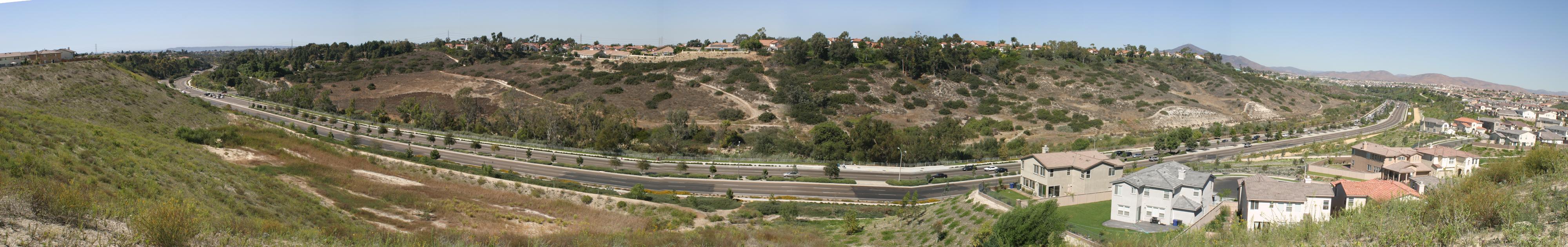 Telegraph Canyon road connects old Chula Vista to the west with the new Chula Vista developments to the east.
|
Sources:
- Bonita Museum & Cultural Center 4035 Bonita Road, Bonita CA 91902.
- Brackett, Robert W. The History of San Diego County Ranchos. 5th ed. San Diego CA: Union Title Insurance and Trust Co., 1960.
- Burkenroad, David C. "Jamul Cement: Speculation in the San Diego Hinterland." Journal of San Diego History 25, Fall 1979.
- Chula Vista city government - GIS maps
- Chula Vista Library 365 F Street, Chula Vista CA 91910, includes the Chula Vista Heritage Museum and Brief History
- Chula Vista Historical Society. Chula Vista, the Early Years. San Diego CA: Tecolote Publications, 1992. 6 vols.
- Coors Amphitheater and Knott's Soak City
- Coleman, Eugene V. The Urbanization of the Sweetwater Valley, San Diego County. M. A. Thesis, San Diego State Univ., 1973.
- Crane, Clare B. "The Pueblo Lands: San Diego's Hispanic Heritage." Journal of San Diego History 37, Spring 1991.
- Dodge, Richard V. "San Diego's "Impossible Railroad'." Railway Historical Society of San Diego, 1956.
- Donaldson, Milford Wayne. Charles Mallory Hatfield: Pluviculturist Extraordinaire. M. A. Thesis, Univ. of San Diego, 2000.
- Eastlake History from Eastlake Company
- Engstrand, Iris. San Diego, California's Cornerstone. Tulsa, Oklahoma: Continental Heritage Press, 1980.
- Federal Land Patent Search, General Land Office Records, Bureau of Land Management, Washington DC.
- Highway 94 Club
- History of Manuel Hatam and the Kumeyaay People in the San Diego Area
- Lee, Lawrence B. "The Little Landers Colony of San Ysidro." Journal of San Diego History 21, Winter 1975.
- Menzel, Spencer L. The Development of the Sweetwater Area (California). M. A. Thesis, Univ. of Southern Californa, 1942.
- National City Public Library 200 East 12th St., National City CA 91950, includes Thelma Hollingsworth Local History Room
- Otay Ranch Communities and Heritage Towne Center
- Otay Ranch Company
- Otay Ranch Planning and Building from City of Chula Vista
- Otay River Valley Regional Park
- Otay Water District
- Painter, Susan Annette. Otay Mesa: a Study of the Impact of Water on Land Use Changes. M. A. thesis, San Diego State Univ., 1985.
- Phillips, Irene. Centennial Commemorating the Purchase of the National Ranch 'El Rancho de la Nacion' by Kimball Brothers. National City CA: South Bay Press, 1968.
- Phillips, Irene, ed. "Diaries of Frank A. Kimball, California Pioneer, Excerpts and Comments." unpublished mss, n.d., National City Public Library Thelma Hollingsworth Local History Room.
- Phillips, Irene. National City: Pioneer Town. National City CA: South Bay Press, 1960.
- Plat Maps from Spanish and Mexican Land Grant Maps 1855-1875, California State Archives, Sacramento, California
- Pourade, Richard F. The Explorers. The History of San Diego. v. 1. San Diego CA: The Union-Tribune Publishing Company, 1960. Chapter 5 describes the Vizcaino map.
- Pourade, Richard F. Time of the Bells. The History of San Diego. v. 2. San Diego CA: The Union-Tribune Publishing Company, 1961. Chapter 5 describes the Pantoja map, the first chart of San Diego Bay, and the Velasquez map, the first map of the interior showing the Sweetwater River as the "Arroyo de la caballada."
- Pourade, Richard F. The Silver Dons. The History of San Diego. v. 3. San Diego CA: The Union-Tribune Publishing Company, 1963.
- San Diego Natural History Museum has recovered fossils from Otay Ranch when it was under water during the Pliocene era 2-4 million years ago - see articles Fall 2001 and Oct. 2001
- Spearman, Arthur Dunning. John Joseph Montgomery, 1858-1911: Father of Basic Flying. Santa Clara CA: Univ. of Santa Clara Press, 1967.
- State Route 125 will connect Otay Valley with SR54 - map
- Taylor, Lawrence D. "The Wild Frontier Moves South: U.S. Entrepreneurs and the Growth of Tijuana's Vice Industry, 1908-1935." The Journal of San Diego History 48, Summer 2002.
- Trook, Leslie. "100 Years of 'Sweetwater'." Chula Vista CA: The Sweetwater Authority, 1988.
- Webster, Karna. Chula Vista Heritage 1911-1986. City of Chula Vista, 1986.
 |
 |
 |
 |
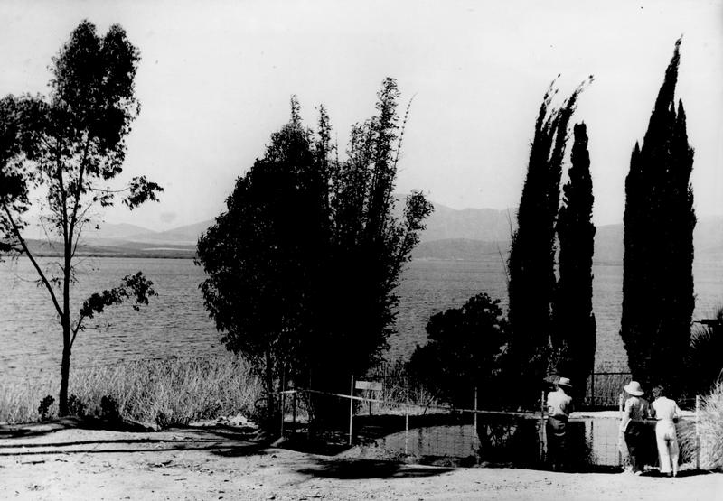 Lower Otay Lakes ca. 1935
|
 flood at Old Town Jan. 1916
|
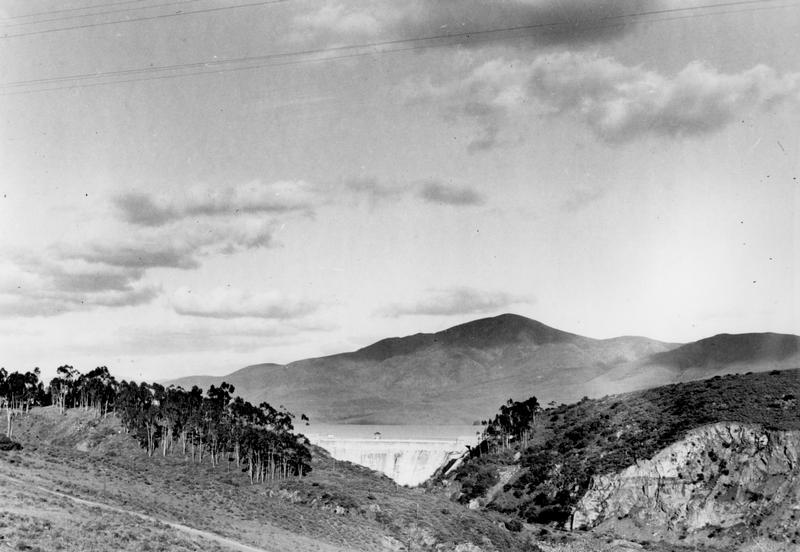 Sweetwater Dam ca. 1935 was the first modern dam of the San Diego water system, on the Sweetwater River, completed in 1888.
|
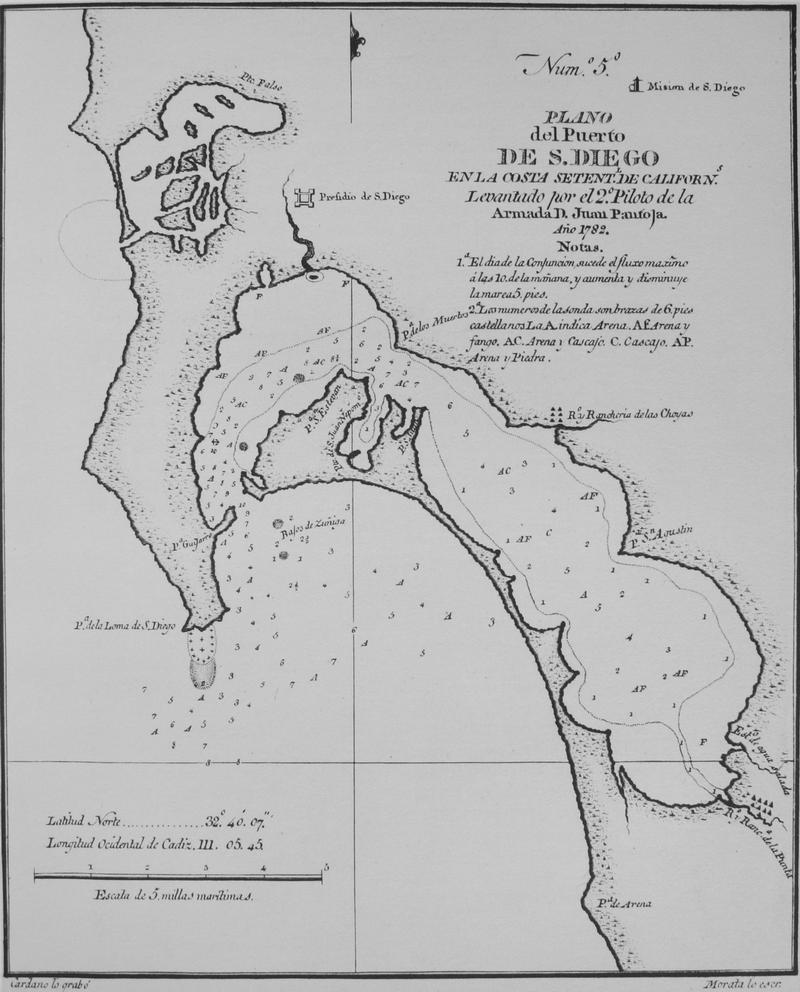 Pantoja map of 1782 as revised by 1786 and printed by Espirosa and Tello in Spain 1802, in Pourade v. 1, p. 149
|
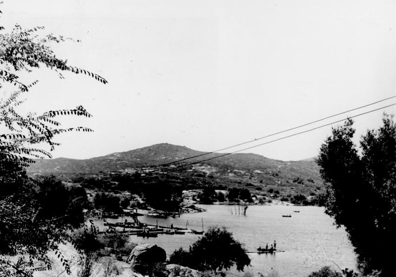 Morena Lake ca. 1935 in the Cleveland National Forest, 52 miles from downtown San Diego. This reservoir is a part of the Otay-Cottonwood water system for the City of San Diego. Charles Hatfield, a professional rainmaker, used this site for his precipitation plant that resulted in a disastrous flood in 1916 that destroyed the Otay dam.
|
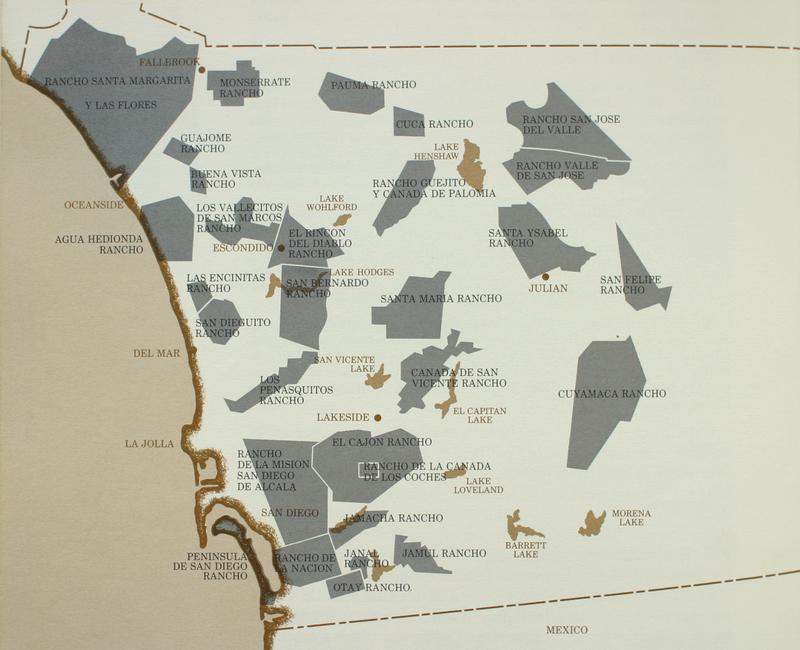 San Diego County ranchos by 1846, in Pourade v. 3, p. 72.
|
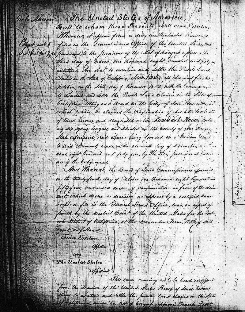 Federal Land Patent issued to Juan Forster for La Nacion Rancho 2/27/1866.
|
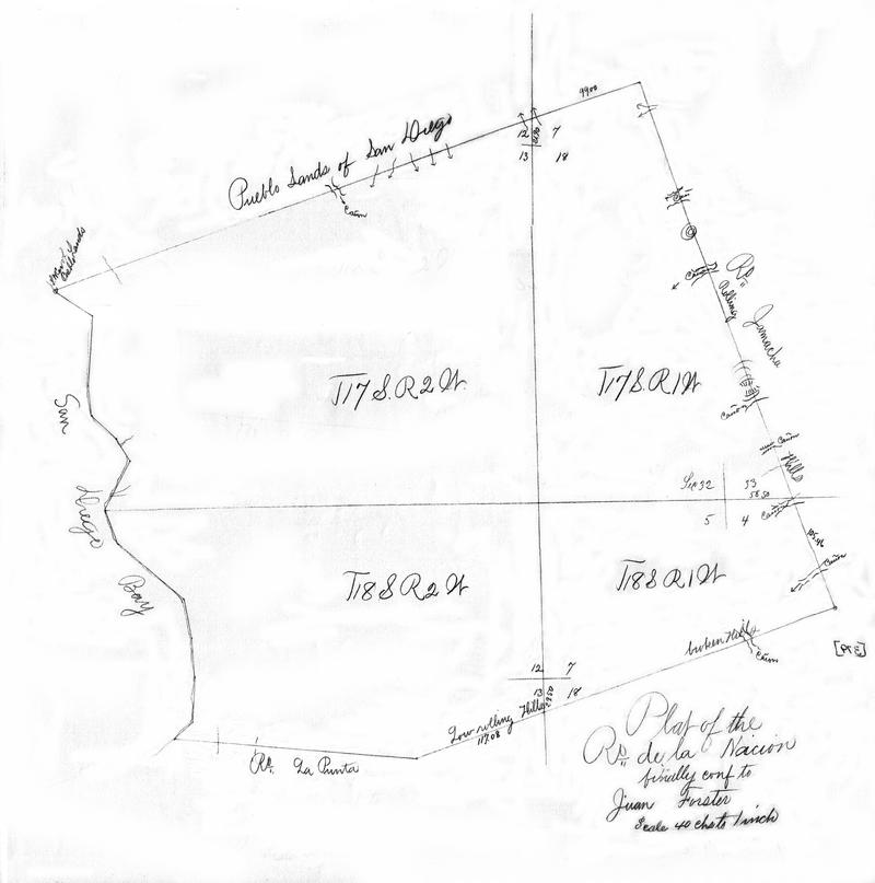 Rancho de la Nacion plat map of 26,631.94 acres confirmed to Juan Forster, 2/27/1866.
|
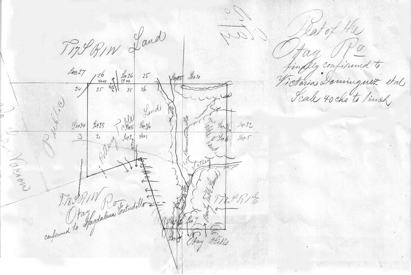
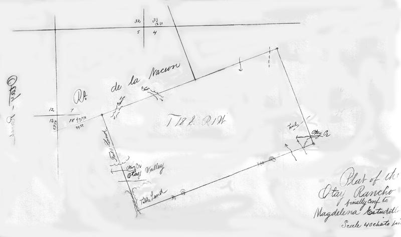 Otay Rancho plat map of 6,657.98 acres confirmed to Magdelena Estudillo, 1/20/1872.
|
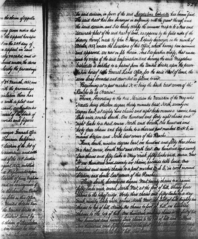 Federal Land Patent issued to Magdelena Estudillo for Otay Rancho 1/20/1872.
|
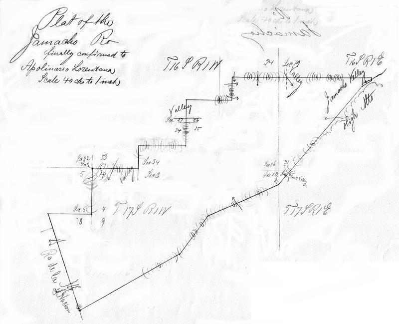 Jamacha Rancho plat map of 8,881.16 acres confirmed to A. Lorenzana, 4/11/1871.
|
 Janal Rancho plat map of 4,437.16 acres confirmed to Victorio Dominguez, 6/13/1872.
|
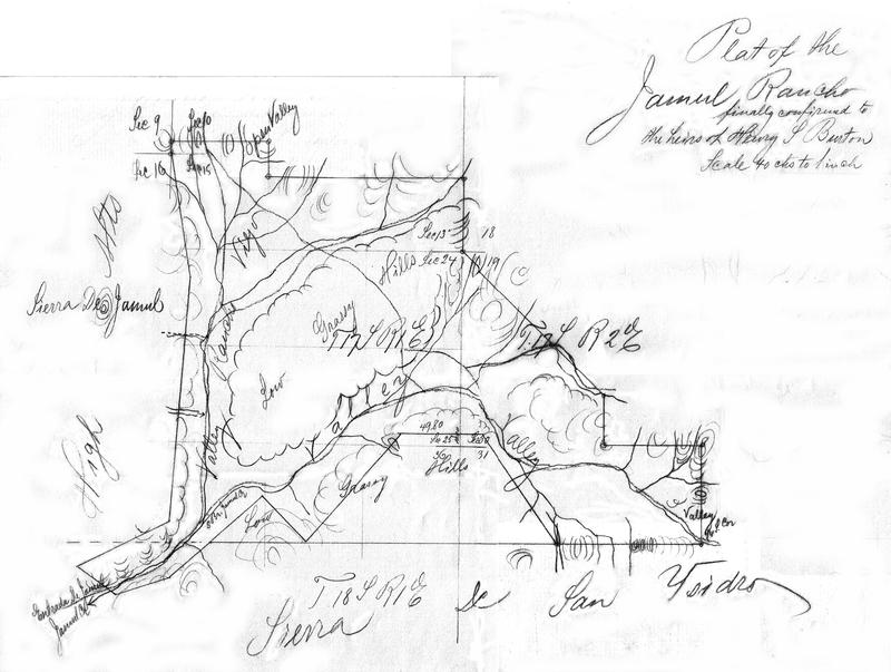 Jamul Rancho plat map of 8,926.22 acres confirmed to heirs of Henry S. Burton 10/26/1876.
|