|
La Punta
by Steve Schoenherr
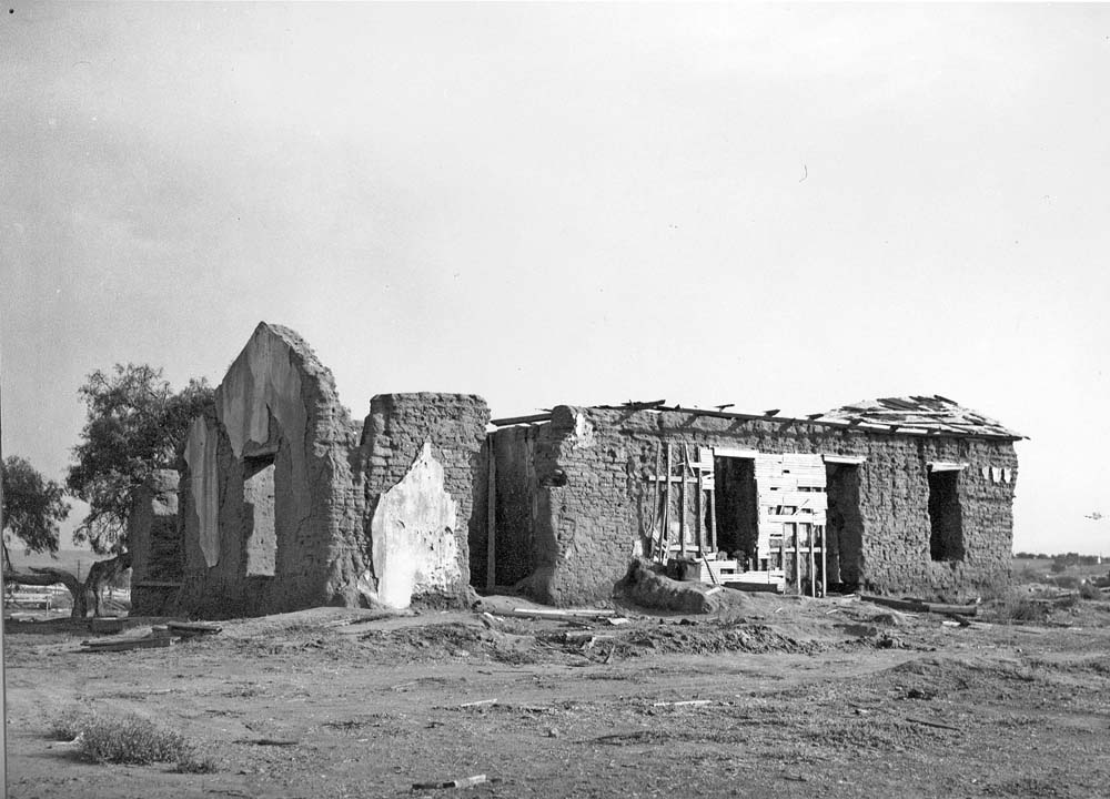
These ruins were all that remained in 1946 of the La Punta adobe of the Arguello family.
The old La Punta adobe no longer exists, but it once was a landmark in an historic region of the South Bay. The area today is bounded by Palomar Street on the north, Main Street on the south, Industrial Blvd on the east, and the salt ponds on the west. When the bay was mapped by Juan Pantoja in 1782, he noted the salt ponds near the mouth of the Otay River and a nearby Native American village he labeled "La Punta." The autobiography of Kumeyaay elder, Delfina Cuero, described how local Native Americans collected the salt to cure fish and as a trade item with other tribes. The first Europeans to walk through the South Bay, starting with Juan Crespi in 1769, followed the paths created by the natives who for centuries came to the salt ponds. The route of Crespi and Serra from the Tijuana River valley north to the San Diego Presidio along the eastern side of the bay became "El Camino Real" in the Spanish era and highway 101 in the 20th century. The road from the eastern mountains to the bay along the north side of the Otay River became Main Street. Where these two roads crossed was near the salt ponds, and it was here, on a bluff above the crossing, that Santiago E. Arguello built his adobe home called La Punta in 1834. He had been granted Rancho Melijo in 1833, an area of several thousand acres located between the Otay River and his father's Rancho Tijuan to the south. From the broad veranda of his L-shaped adobe, Arguello had a magnificent view of the bay to the west, the old Spanish grazing lands called Rancho del Rey to the north, the Otay River valley to the west, and the Tijuana River valley to the south. When Frank Kimball bought the grazing lands in 1868, by then called Rancho Nacion, he marked his southern boundary as a diagonal line, today's Palomar Street, to avoid the home of Arguello.
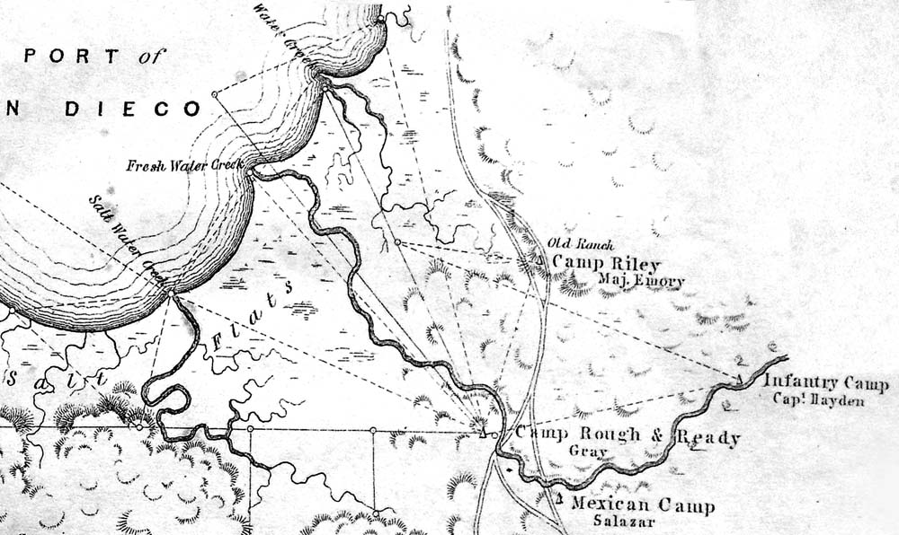
La Punta was the "old ranch" on this map drawn by surveyor Andrew Gray in 1849 when he worked with Lt. William H. Emory on the U. S. Boundary Commission to establish the boundary after the war with Mexico. Emory's Camp Riley was named after the senior military officer in California, General Bennett Riley.
Santiago E. Arguello was not successful in keeping his La Punta land grant. His appeals were rejected by the Land Commission Dec. 20, 1853, and by the courts Sept. 20, 1855. Arguello sold his interest in the rancho on Sept. 1853 to Jose Antonio Aguirre for $30,000. However, his wife Guadalupe Estudillo Arguello continued to appeal for ownership of the rancho until 1873, but more than 75 squatter farmers had settled on the rancho and fought against the Arguello appeals, and in 1873 won their case and were allowed to keep their claims. Although the Arguellos lost the rancho land grant, they kept ownership of the 60 acres around their adobe home.
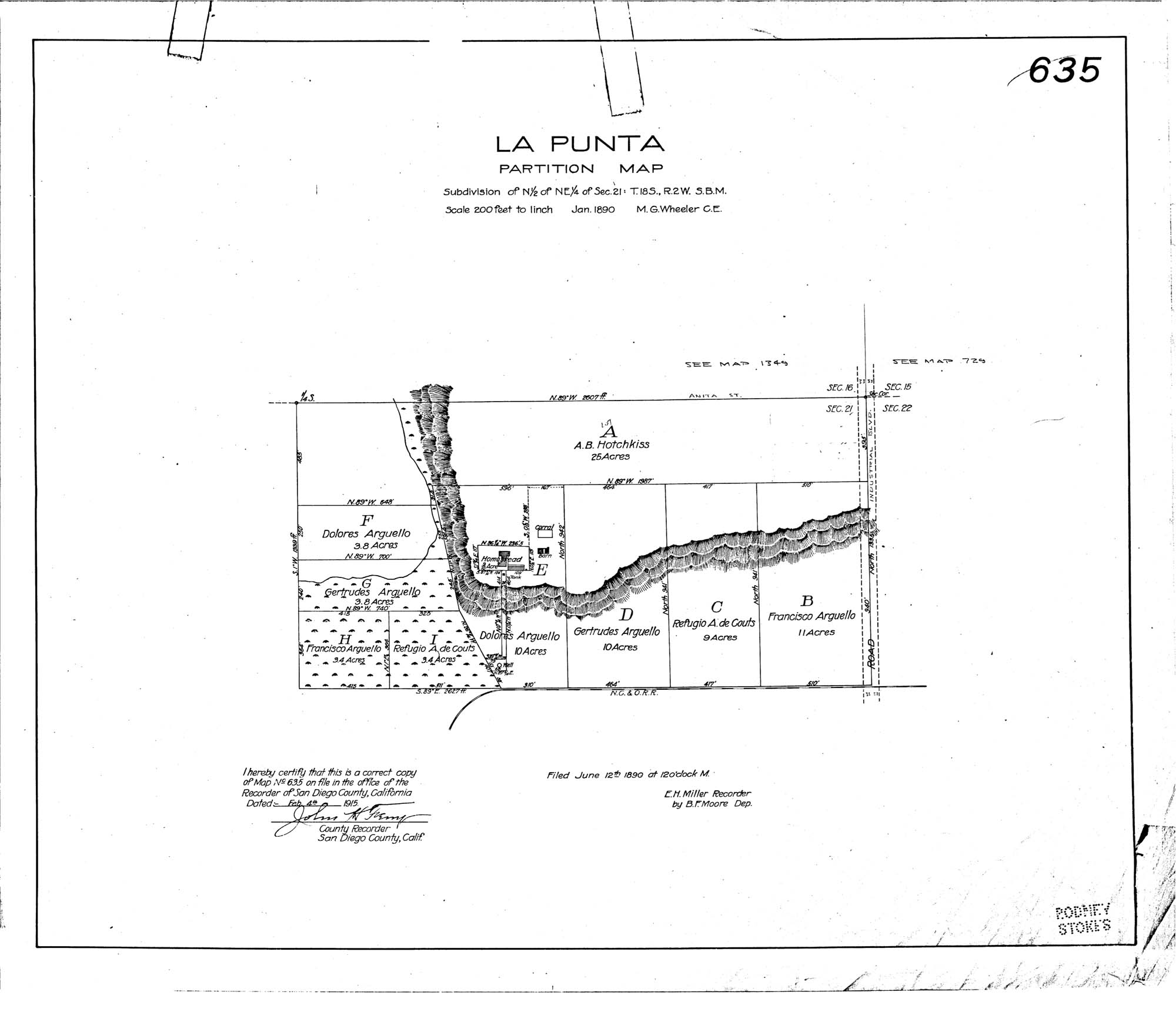
La Punta subdivision map No. 635 filed June 12, 1890.
Alfred H. Wilcox came to La Punta after he married Maria Antonia Arguello, oldest daughter of Santiago Arguello, in a double wedding in 1863 with Refugio Arguello and W. Blount Couts who also moved to the old adobe. Wilcox built his Fruitland ranch and home near La Punta, and in 1871 leased it to Henry von Poser who built a resort and picnic area called "La Punta Gardens." The gardens became a popular spot for boaters who began to sail the bay in the 1870s. Irene Phillips wrote in her book San Diego Land & Town Company, "Sailing on the Bay had been a pastime of long standing. Even as far back as January 6. 1873 the San Diego World described the 'Wilcox Gardens' at La Punta as 'A picnicking spot punctuating a day's sail up the Bay and back.' In March of 1888 the Record advertised an excursion, 'A trip to the Wilcox Gardens at La Punta at the foot of the Bay makes an enjoyable day's outing for here, American lads and lassies are transplanted back to hacienda days when Santiago Arguello, the last Commandante of the San Diego Presidio, lived m the large adobe house which he built near the mouth of the Otay River'." By 1882, a post office was established at Fruitlands and Zachariah Montgomery, appointed Postmaster, purchased the Wilcox ranch. Zachariah's son was John J. Montgomery who designed a glider in his workshop on the ranch. On August 28, 1883, Montgomery flew his glider from a hill above the Otay River, and became the first to succeed at controlled flight in an "aeroplane," a word first coined by Montgomery. La Punta had always been at the center of a transporation crossroads, from the ancient salt paths to the roads of the Spanish missions. It became a stagecoach station in 1869 when John Capron began daily service from San Diego to the Otay Valley, then east to Yuma. In 1888 the Coronado Belt Line built a station at Fruitland for its railroad around the bay from San Diego to the Hotel del Coronado. The Fruitland station also served to ship out the growing production of the Salt Works. Josiah Shaffer and George Stone started making salt in 1871 on 60 acres northwest of La Punta. The San Diego Union reported in 1872 that "Shaffer and Stone of the La Punta Salt Works have succeeded in making an article of table and dairy salt in no wise inferior to the best in the San Francisco market." In 1874 it reported "La Punta Salt is now on hand and for sale in quantities to suit purchasers by W. W. Stewart & Co., agents for the works. Sacks of all sizes, from three to fifty pounds." Josiah Shaffer's sons, Eugene and Josiah Elmer Shaffer, bought out George Stone's interest in the Punta Salt Works, and in 1888 renamed the company as the Otay Salt Works. The company became Western Salt in 1902 when it was purchased by Elisha Babcock and his son Graham Babcock. The plant was destroyed in the 1916 flood, but Graham rebuilt the solar evaporation ponds and constructed a larger processing plant. According to the Salt Works Site Assessment and Draft Vision Plan of 2008,"The Western Salt Company made a significant contribution to the entire solar salt industry during the period of 1916 to 1949. The Main Processing Plant and the other historic buildings on the Western Salt Works Company property were instrumental to the process of commercial solar salt production that occurred during the early-to-mid twentieth century. In regards to the Main Processing Plant building, it is clearly an extremely rare example of a solar salt processing plant. It is the only one of its kind found in San Diego County. The Main Processing Plant and the Western Salt Works Company property in general are landmarks of the early industrial development of San Diego Bay, and the broader history of California's solar salt industry."
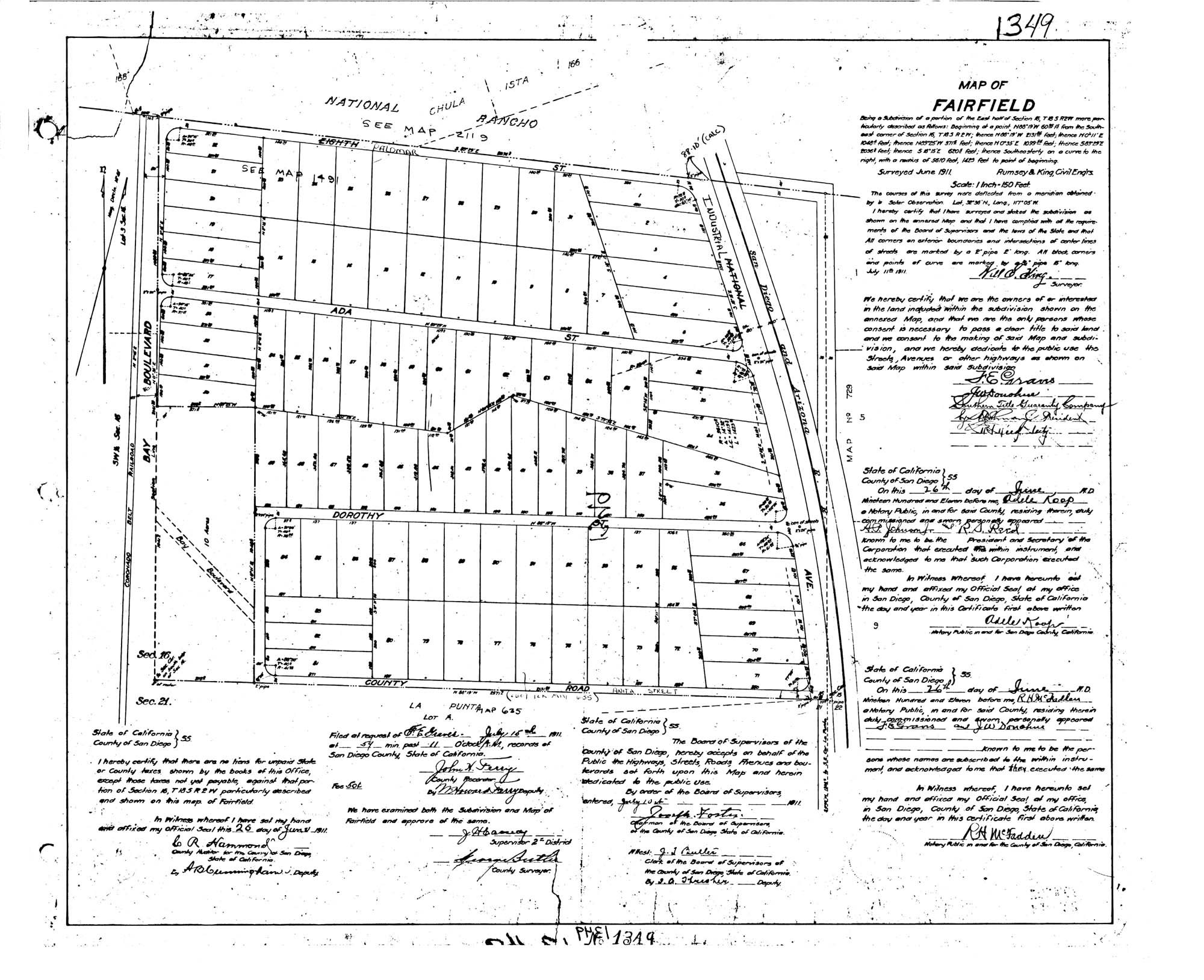
Fairfiled subdivision map No. 1349 filed June 26, 1911.
During the growth period of Western Salt after 1916, workers built homes in the Fairfield subdivision east of the plant, along Dorothy and Ada streets. This subdivision and its streets were created by the Norton Land Company in 1911 and 1912. Among the workers who came to this area were Felix and Urbana Casillas came from Mexico through the El Paso port of entry. Felix found work at the Westvaco chemical company next to the Salt Works. He first lived in the La Punta adobe, then built his own adobe home at 828 Dorothy Street in 1920s, and lived there until it was demolished for the freeway in 1950s. They had 9 children; the 7 brothers included Joseph Casillas, a WWII hero, and Armando A.Y. Casillas, the first Hispanic elected to the Chula Vista Elementary School Board in 1966, and Nicolaz Casillas, father of Mary Salas who served two terms on the Chula Vista City Council and later served two terms in the California Assembly.
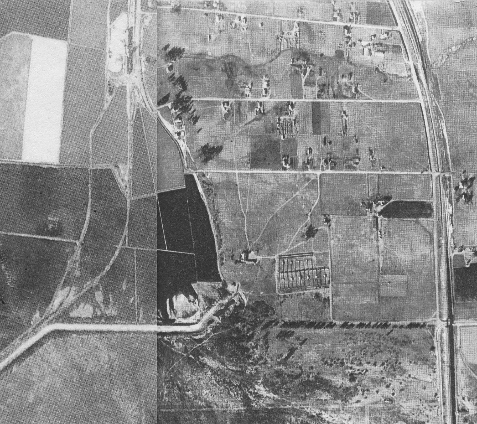
This aerial photograph taken by San Diego County between November 1928 and March 1929, shows the salt ponds and Salt Works on the left, along Bay Boulevard that curves inland following the bluff line and connecting with Anita Street. At top is Ada Street slanting slightly northward, then Dorothy Street next to the south, then Anita Street. Several dozen homes can be seen along these streets that were in the Fairfield subdivision. On the right is Industrial Boulevard that paralleled the San Diego and Eastern Railroad. Below Anita, serveral dirt paths lead to the L-shaped La Punta adobe, with a series of chicken coops to the east. At bottom is the Otay River, and bottom left is a cluster of trees where the Montgomery ranch had been located.
The Palomar Gateway District Specific Plan Cultural Resources Report prepared by ASM Affiliates in 2013 concluded: "Several buildings within the project area are at or older than the 45-year threshold at which they should be considered for potential eligibility for the NRHR, CRHR and local designation. According to the City's assessor data, the western portion of the Project area has parcels which date from 1910 to 1959. A USGS map from 1967 identifies several more buildings that have reached the 45-year threshold along Anita and Dorothy Streets to the south of the Project area as well as in the northwestern section on Walnut and Trenton Avenues. Visual observation during the reconnaissance survey confirmed those dates, and noted that multiple other parcels also date to that period. ASM estimated that there were approximately 95 buildings within the Project area that potentially met the age threshold of 45 years or more. Of these, three were noted as being the most likely to be eligible for the NRHR, CRHR, and the City of Chula Vista Local Register, as representative examples of architectural styles and/or early Fruitdale residential buildings, which retain a good degree of integrity. Those buildings are located at 805 and 753 Dorothy Street and 755 Ada Street. The buildings at 805 and 753 Dorothy Street have been previously recorded and recommended as ineligible for the CRHR and as a Chula Vista Landmark. It should be noted that both evaluations took place in 2006, prior to the recent adoption of the Chula Vista Historic Preservation Ordinance, and the new criteria for local eligibility established therein. The following are potential historic resources recommended for future evaluation: 754 Dorothy Street, 729 Dorothy Street, 715 Ada Street, 778 Ada Street, 799 Ada Street, 1196 Industrial Blvd."
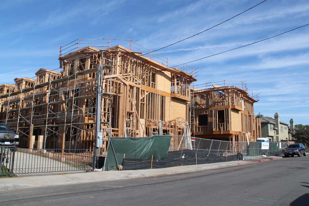
The potential historic house at 778 Ada Street has been demolished for the construction of the Ada Villas townhomes.
After the death of Santiago Arguello in 1857 and his wife Guadalupe Estudillo in 1889, La Punta was owned jointly by Alberto Couts, Dolores Arguello and Tula Hubbard, then ownership passed to Mrs. Mary Longstreet, another Arguello heir living in Los Angeles. She sold to the state of California when the Montgomery Freeway was platted through her tract. During World War II a small detachment of soldiers used the old adobe as a lookout station. It fell into ruins and was finally destroyed by the freeway construction in 1951. A few of the old heavy doors and some beams were moved to the Vincent Davies Dairy property several miles east in the Otay River valley. The California Highway Commission passed a resolution to construct a freeway from the Mexican border at San Ysidro to the southern terminus at Harbor Blvd. in San Diego on August 21, 1947. The freeway was given the name "Montgomery Freeway" in honor of John J. Montgomery, the glider pioneer who made his first flight in 1883 near the ranch that was also in the right of way of the freeway. Construction of the freeway from National City to G Street in Chula Vista began in early 1950. By April, 1952, the four-lane road was open to Palm City with turnoffs at E and G and H streets. By June 17, 1955, the freeway was open to the border. By June 1, 1957, the interchanges at Dairy Mart Road, Palm City and Palomar Street were completed.
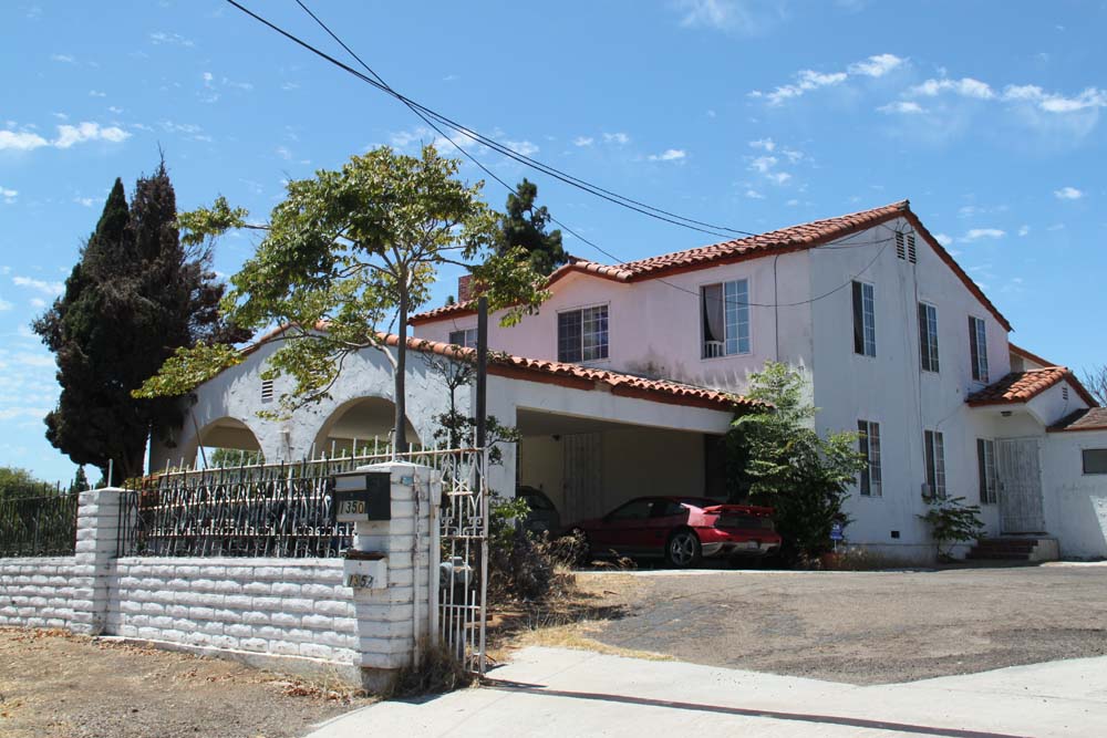
The housing boom of the 1950s meant the end of farming in the South Bay. This home at 1350 Industrial Blvd was built by farmer Claudio Gonzalez in the 1930s at its original location at Broadway and Palomar where there were many farms and lemon orchards. When the area began to develop, it was sold to Jesus Martinez who moved it to its present location across the tracks from the Palomar Trolley station.
The freeway and the widening of National Avenue, renamed Broadway in 1955, brought growth to the southwest region. The Palomar Inn opened in 1954 on the southwest corner of the freeway's new Frontage Road and 8th Street, renamed Palomar Street. The Harborside tracts were annexed by the city in 1958, with the new city limits expanded down from L Street to the south side of Palomar Street, including the Palomar Inn. Much of Harborside No. 2 became the Brentwood Trailer Park in 1959. The Western Salt Company did not want to be annexed by Chula Vista, and instead was annexed by the city of San Diego on Apr. 25, 1955. San Diego added another large part of the southern region in 1957 by annexing Palm City, Nestor, Otay Mesa, and San Ysidro. Imperial Beach opposed the annexation and voted June 5, 1956 to incorporate as a sixth-class city. The actions of Western Salt and San Diego stopped Chula Vista from expanding in the southwest until 1985. On Dec. 31 of that year, The Montgomery annexation of 3.5 square miles from L Street to the Otay River included Fairfield and the La Punta district.
The Bayshore Bikeway is a 24-mile route around the bay, initially proposed by Sen. James Mills in 1975. It runs through West Fairfield, from Bay Blvd east on Stella Street, then south on West Frontage Road to Swiss Park at Main Street. A display of metal bike sculptures on West Frontage Road encourages bikers to stop and take a photo.
The Bayshore Bikeway staging area at Swiss Park was opened in 2013. According to Allison Sampite-Montecalvo in the Union-Tribune, "A staging area at Chula Vista's Swiss Park will provide a vital link between the Bayshore Bikeway and Otay Valley Regional Park trail beginning Oct. 12. The area provides a gathering place for people to meet up, park and access the two trail systems and is a collaboration between the county's Parks and Recreation Department, U.S. Fish and Wildlife Service and Swiss Park. County Supervisor Greg Cox said the Swiss Park staging area was created to further trail connectivity. It includes nine parking spaces, one place for an ADA accessible van with an accommodating portable restroom, and bicycle rack. "The bottom line is this will be available to the public free of charge from sunrise to sunset," Cox said. The trail itself is surrounded by history. Tony Odermatt, Swiss Club president, said his family has been in the area for three generations. In the 1930s and '40s, a group of farmers formed the Swiss Club to keep their heritage alive. "My grandfather bought the property back in the '30s and made it into a public park," Odermatt said. "He traded that with another piece of property with city of San Diego ... and it became Swiss Park." Today Swiss Park is used mostly as a place that people can rent for wedding receptions, banquets, birthday parties, corporate events and dances. "A while back Greg Cox came to me and asked if we could allow them to use an area of our parking lot," Odermatt said. "We thought it was a way to give back to the city and in turn they could help us." So he worked out an agreement that had the county redo its parking lot while Swiss Park became responsible for the upkeep of the area. "We wanted to be good will ambassadors to the city, county and community," Odermatt said."
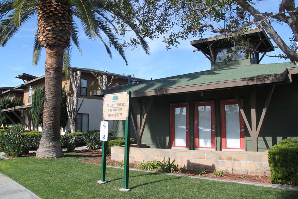
Trolley Terrace Townhomes on Ada Street were built in 1999.
In 2003, Amy Oakes reported in the San Diego Union-Tribune the growing interest in the redevelopment of the Fairfield district. "This stretch of Ada Street -- behind the popular pumpkin patch field -- is full of history, a place where some families have lived in the same bungalows since they were built in the 1920s. It also is an area worn down with age. Some homes have deteriorated beyond repair, and the neighborhood has seen better days. So when a developer proposed building townhomes here, city officials welcomed the opportunity. They said it could serve as a catalyst in the revitalization of one of the city's older neighborhoods. "It will be a great enhancement to the area," said Councilwoman Mary Salas, who still has relatives living on the street. Salas and the rest of the council last week approved the developer's two projects at 774 Ada St. and 815 Ada St. The developer, Jim Truesdale, proposes to build 14-unit townhome complexes at each site. They will be similar to a 12-unit townhome complex -- Ada Villas -- which was approved last June and is under construction at 777 Ada St. Truesdale said the three-bedroom, three-bath townhomes will be similar to Moss Villas on 345 Moss St. The two-story homes will have two-car garages and probably sell for $290,000 to $325,000, he said. The new projects, Ada Terrace and Ada Court, are scheduled to be completed in 14 months, Truesdale said. The Ada Terrace project calls for seven two-unit buildings and a 24-foot-wide driveway through the center of the property. The Ada Court project calls for four buildings, each with two homes, and two three-unit buildings. A 20-foot-wide driveway will provide access to the homes. Ada Street is part of the East Fairfield neighborhood, an area targeted for redevelopment, said Harold Phelps, an associate planner for the city. Some of the homes were built in the 1920s, others in the 1940s and 1950s. There have been successful affordable-housing projects built nearby, such as Trolley Trestle and Trolley Terrace. Truesdale's project is one of a handful of new developments in the city's older neighborhoods west of Interstate 805. City officials say developers have recently taken an interest in building in these already developed areas. Miguel Tapia, a senior community development specialist for the city, said developers also have expressed interest in a privately owned, 4-acre site zoned for commercial use near Truesdale's projects. It was a popular location to buy pumpkins at Halloween and trees at Christmas. "It's got a very strategic location," Tapia said. "We're really wondering what kind of project would be the best use." Truesdale, who lives in Coronado, said the area is in an ideal location for his residential projects. The homes would be near the trolley station at Palomar Street and Interstate 5. The developer said he is confident the townhomes will sell as fast as the Moss Street project. That 14-unit townhome complex was finished in August 2002 and filled within 30 days, he said. "There's just a severe need for housing," Truesdale said. City Councilman John McCann said new homes, selling at market rate, will be a good investment. It will not only provide much-needed housing, he said, but also quality homes. "This is definitely a steppingstone for revitalizing that area," he said."
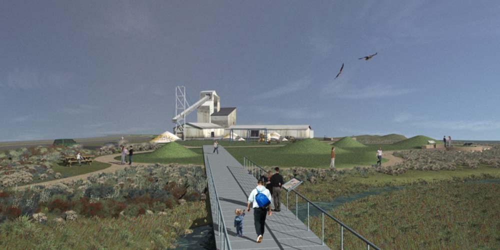
A design for a future Salt Works Interpretive Center by the Schmidt Design Group won the American Society of Landscape Architects 2009 Merit Award.
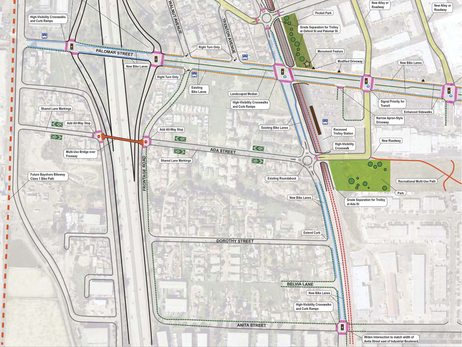
The most recent update to the City of Chula Vista General Plan occurred in 2005. The main focus of the update was primarily focused on the currently developed areas of the city, in particular the western portions of the City. Within the Southwest portion of the City, the General Plan designated five areas of change that would need to go through a more detailed planning process. One of these areas is the Palomar Gateway District. The purpose of the 2013 Palomar Gateway District Specific Plan is to encourage an appropriate mixture and density of activity adjacent to the existing San Diego Trolley light rail transit station at Palomar Street. The Specific Plan was created to promote a pedestrian, bicycle, public transit, and private automobile-supportive development environment and by integrating these mobility elements with a complementary mix of land uses, all within a comfortable walking and bicycling distance from the light rail station. The potential for the Palomar Gateway District to evolve from a low-density auto-focused interchange into a higher density transit oriented community has been recognized both by SANDAG's Vision 2020 Plan, which designated the Palomar Gateway District as a "Community Center" and by Chula Vista's 2005 General Plan, which calls for the district to be developed as a Transit Focus Area. Progress towards this vision is already underway, with the $2.1 million pedestrian/traffic improvements on Palomar Street and Industrial Boulevard provided by the 2005 Transnet SGIP grant, which were completed in the fall of 2009. Among the General Plan Policies related to the Palomar Gateway District are the following: Amend the Parks and Recreation Master Plan to add a new "urban park" definition for parks that may be developed within western Chula Vista, subject to specific siting, design and park dedication and credit criteria. And, consider the design of non-traditional, uniquely themed parks such as the Otay River Valley Park and the Bayfront that are "stand-alone" attractions or destinations, having unique character and features. One of the visually outstanding physical features of the Palomar Gateway District is an existing drainage, that runs east-west from Industrial Boulevard to Frontage Road along the rear of private properties located south of Ada Street and north of Dorothy Street. The drainage extends for approximately 1,430 linear feet, and has a width that ranges from approximately 30 feet to 100 feet at different points through its longitude. The drainage represents a potentially valuable "greenway" that should be preserved and enhanced for the enjoyment of the contiguous property owners.
Palomar Gateway plan 2013.
SOURCES:
|
|||||||||||
|
Home •
About Us •
Next Meeting •
Latest News •
Resources •
Organizations •
Exhibits •
Bulletins
Contact
|
|||||||||||
|
This web page was created Dec. 12, 2014 by Steve Schoenherr for the South Bay Historical Society | Copyright © 2014
|