|
South Bay Historical Society
Home •
About Us •
Next Meeting •
Latest News •
Resources •
Maps •
Exhibits •
Organizations •
Histories •
Contact
|
|||||
|
Prehistoric South Bay
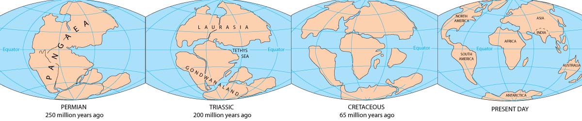
Pangea Historical Perspective from USGS
300mya (million years ago) - The shoreline and bay of what later would become San Diego was in the middle of the Pangea super-continent, east of the super-ocean Panthalassa. It was an era of severe widespread volcanism that came to a sudden end with the Permian extinction 250mya, probably caused by the impact of a large comet or meteor. This was followed by the warm arid climate of the Triassic epoch 240-200mya and rise of dinosaurs. No fossils from this age of dinosaurs have been found in San Diego. The oldest dinosaur fossils found in North County were the duck-billed hadrosaur and armored nodosaur from 75mya. 200mya - The breakup of Pangea caused the continents to form and began the collision of tectonic plates on the crust of the earth. As the North American Plate pushed westward over the thinner Pacific plate, magma rose to form mountains, large oceans formed and the sea level rose from 200mya to 90mya.
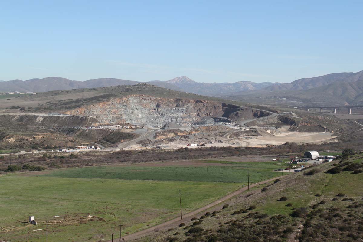
Rock Mountain is on the northern side of the Otay Valley. The Native American village of Otai was beyond Rock Mountain, on the other side of the Highway 125 bridge.
150mya - The Peninsular Range of granitic mountains was formed from the magma of the Jurassic epoch caused by the subduction, or overriding of tectonic plates. Palomar Mountain (6,126 ft.), Cuyamaca Peak (6,515 ft.), Otay Mountain (3,572 ft.), San Miguel Mountain (2,573 ft.) and Mother Miguel Mountain (1512 ft.) were in this granitic range. These mountains formed an island arc in a submerged landmass that would not emerge as the dry land of Southern California until 65 mya. There were no dinosuars or any land mammals in Jurassic San Diego. The oldest fossil found in Chula Vista was a squid-like belemnite from this epoch 140 mya, found in Proctor Valley in the marine sedimentary layers around the base of Mother Miguel mountain. 128mya - In the Cretaceous epoch volcanic activity replaced subduction as the primary cause of mountain-building. The molten rock that came up produced the Santiago Peak Volcanics on the western side of the Peninsular Range, covering Otay Mountain and the San Ysidro mountains. It produced Rock Mountain in the Otay Valley that became a valuable quarry for high-quality stone in the 20th Century. In this Cretaceous epoch, the coastal plain of California was under water and a great inland sea covered most of the western United States east of the Peninsular Range. Giant sea creatures such as mosasaurs swam in this inland Cretaceous sea until 66mya. 66mya - The K/T extinction event marked the end of Cretaceous epoch. The sea receded and the California coastal plain was above sea level for the next 13 million years. 53mya - The sea level rose and again covered the coastal plain during the Eocene epoch. This period resulted in a deep sedimentary layer called the Sweetwater Formation, located east of Chula Vista (an exposure of this formation can be seen in the Otay Valley, at the mouth of Wolf Canyon and the canyons between Rock Mountain and Salt Creek.) 42mya - The sea level fell during the late Eocene epoch and the coastal plain in Southern California was above water. Marine fossils such as clams and snails have been found in Otay Mesa and Spring Valley. Terrestial fossils from opossums and rodents have been found in Bonita from this Eocene period. 28mya - During the dry era of the Oligocene epoch, hot ash from Mexican volcanoes fell on the Chula Vista region creating the Otay Formation of bentonite. The river valleys of the Otay and Sweetwater were created during this era as sea level fell and erosion washed soil down from the Peninsular Range. Many Oligocene reptile and bird and mammal fossils have been found in EastLake and Proctor Valley.
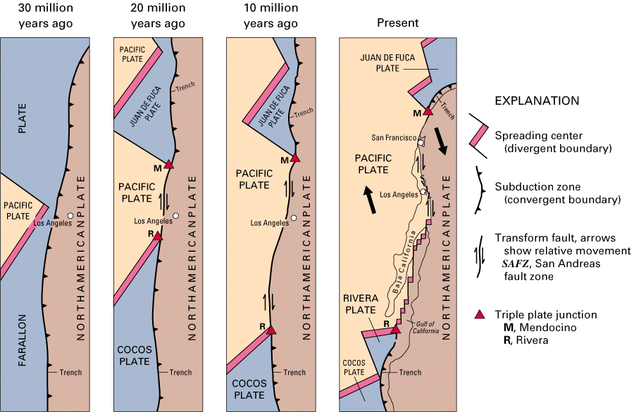
Plate Tectonics from USGS
16mya - The shoreline was located near Eastlake in the Miocene epoch. Mammal fossils (such as the oreodont) have been found in EastLake near this shoreline. As the Pacific Plate moved northwest in the Miocene epoch, sliding past the North American Plate, faults were created such as the Rose Canyon fault and the San Andreas fault (eventually, Los Angeles will become a western suburb of San Francisco). The Nacion fault that follows the line of the I-805 freeway east of Chula Vista was a basin fault caused by the down-dropping movement of the San Diego area. In the Miocene, the Baja Peninsula began to separate from mainland Mexico.
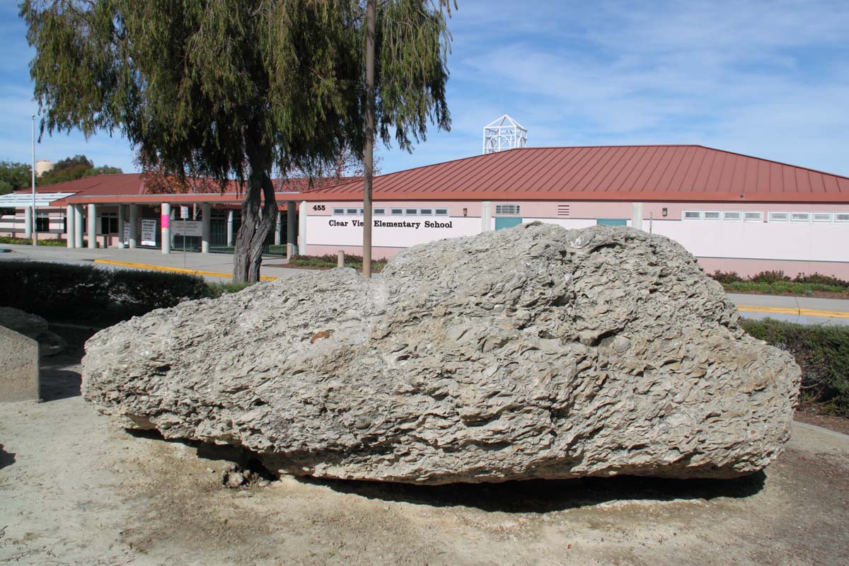
Fossils are embedded in a large boulder at Clear View elementary School
5mya - The shoreline was a giant crescent from Mt. Soledad to Rosarito, extending east to Lemon Grove and Proctor Valley. The fossil of a sea cow and baleen whale were found on Otay Ranch. Marine fossils such as clams and sand dollars were found near Clear View Elementary School in what was called Fossil Canyon (filled in to form Hidden Vista Drive in Terra Nova in 1979). A toothless walrus from 3mya was found in Rancho del Rey, and was given the name "chulavistensis" in honor of Chula Vista's rich yield of Pliocene and Pleistoscene fossils. The climate of the South Bay along this ancient shoreline was subtropical with lush vegetation. Large mammals such as horses and camels and mastodons walked the land of today's Otay Mesa. 650,000ya-20,000ya - A series of Ice Ages cooled the climate, with giant glaciers covering parts of North America and Europe, but no ice sheets covered San Diego. The sea level fell and the shoreline was 3 miles west of today's shore. 10,000ya - The Holocene epoch began as glaciers retreated, the climate warmed, the sea level rose. The San Dieguito people settled on the coastal plain and in the river valleys. The oldest prehistoric settlements in the South County are in the upper Otay Valley near Otay Dam (site W-170 found by Malcolm Rogers ) and Otay Valley near Rock Mountain (SDI-12,809 excavated by Charlotte McGowan) and Spring Canyon on Otay Mesa (SDI-10808 and 10809) and Remington Hills on Otay Mesa (SDI-11079 southeast of I-805 and I-905).
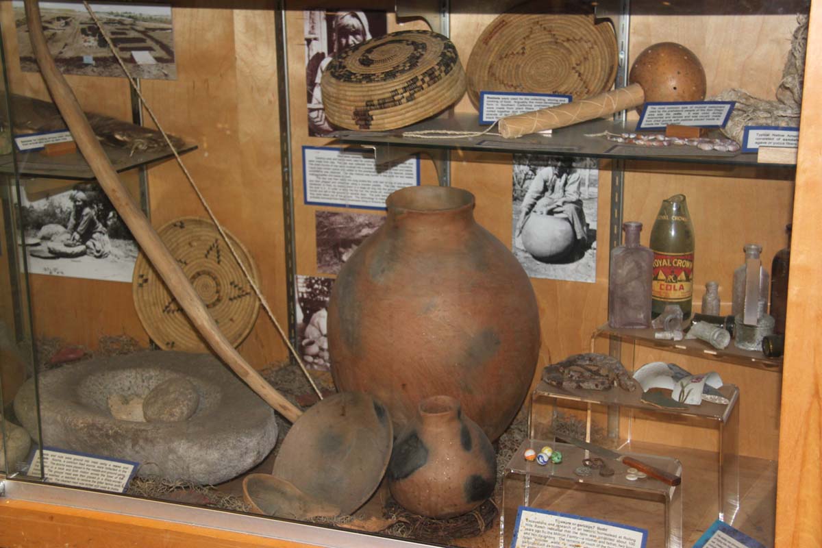
Artifacts on display at Thurgood Marshall Elementary School in Rolling Hills
6,600ya - The sea level stabilized at present day levels and San Diego Bay took on its current shape. By 4,000ya the ocean currents pushed sand northeast to form the Strand along the western side of San Diego Bay. The La Jollan people lived from 7,500ya to 3,000ya. The Kumeyaay (or Southern Diegueno) migrated to this area sometime between 3,000-2,000ya. The Rolling Hills Ranch site on Proctor Valley Road was occupied from 6,000ya to 1,000ya by La Jollan and Kumeyaay people. 1769 - When the Spanish settled in San Diego, there were several thousand Kumeyaay living in the South Bay. Large villages that the Spanish called "rancherias" were located in the Otay Valley (La Punta at the western end and Otai at the eastern end where McGowan found SDI-12,809). The rancherias disappeared and the Kumeyaay declined to several hundred by the census of 1860. SOURCES: Abbott, Patrick L. Rise and Fall of San Diego: 150 million years of history recorded in sedimentary rocks. San Diego, CA: Sunbelt Publications, 1999. Carrico, Richard L. Strangers in a Stolen Land: American Indians in San Diego, 1850-1880. San Diego, CA: Department of American Indian Studies, San Diego State University, 1986. Clifford, Harold J., et. al. Geology of San Diego County: Legacy of the Land. San Diego, CA: Sunbelt Publications, 1977. Deméré, Thomas A. "Geology of San Diego County," San Diego Natural History Museum, http://www.sdnhm.org/research/paleontology/sdgeol.html Farrand, Gregory T., ed. "Geology of Southwestern San Diego County, California, and Northwestern Baja California." San Diego Association of Geologists, 1977. Fossil Mysteries Geologic Timeline, San Diego Natural History Museum, https://www.sdnhm.org/archive/exhibits/mystery/fg_timeline.html Geology of San Diego County, San Diego Natural History Museum, http://www.sdnhm.org/research/paleontology/sdgeol.html McGowan, Charlotte. Final Report of the Excavation of Cal. F:5:1 (CA-SDI-12,809). Chula Vista, CA: The Author, 1997. |
|||||
|
Copyright © 2014 by South Bay Historical Society
|