|
Otay Ranch
Ranchos of the South Bay by 1845
Prehistoric EraSee Prehistoric South BayDuring the Cretaceous Epoch (138-66 million years ago), the coastal plain of California was under water and a great inland sea covered most of the western United States east of the Peninsular Range. ( Clifford, 1997, p. 52. ) During the Oligocene Epoch (38-24 million years ago) the sea level fell and southern Coastal Plain Region was dry land. The sedimentary rocks from the Otay Formation of this epoch were exposed by development of the Eastlake community in eastern Chula Vista. Here significant skeletal remains of terrestrial reptiles (tortoise and lizards), birds (bathornihids, cranes, and quail), and mammals (e.g., insectivores, gophers, mice, beavers, dogs, nimravids, rhinoceros, camels, oreodonts, and chevrotains) have been collected along with sparse fossil impressions of freshwater plants (e.g., rushes). These Oligocene-age strata also occur in the Proctor Valley and Bonita-Sweetwater areas of the unincorporated County. ( Russell and Beddow, "Guidelines for Determining Significance Cultural Resources," 2007.) Pat Sena, a young field paleontologist for the San Diego Natural History Museum, is surveying at Otay Ranch in Chula Vista. Last week, Sena found something he and other paleontologists had never seen before in the area: hoof prints. The prints, marvelously preserved in hardened mud, were spotted by Sena after earth-moving equipment had leveled off the top of 30 feet of soil. "We lose a lot of (fossils) to construction, but without it, we probably wouldn't find any of this stuff," Sena said. The prints represent the first horse hoof prints found west of the Anza-Borrego Desert and mountains. "It's really interesting to find them so close to the sea," said Tom Demere, curator of paleontology for the Natural History Museum. Sena and other researchers quickly began excavating the site, exposing a 20-foot square that contained about 30 distinct prints. Scientists believe the track field is actually much larger, extending perhaps hundreds of yards in all directions. "This could be the largest track field in the world," said Richard Cerutti, a field paleontologist working with the museum. Plans were made to make molds and, if possible, extract a portion of the track field for return to the museum. After that, earth-moving crews will resume their work at the site. From this information, Demere said researchers hope to expand and elaborate what they know of animal life in San Diego County during the Pliocene and Pleistocene periods, a time span that covers from 5 million years to roughly 10,000 years ago. (We live in what is known as the Holocene period.) The hoof prints, for example, appear to belong to an extinct horse species called Plesippus simplicidens. "It looked a lot like the modern horse, only smaller and stouter. Maybe like zebras today, without the stripes," said Sena. Four million years ago, Plesippus simplicidens was nearing the end of its run. For reasons not yet understood, it and dozens of other species, from llama-like camels and elephantesque proboscideans to lions and cheetahs, suddenly, inexplicably perished. "It's really a giant mystery why horses and these other animals died off in North America," said Sena. Theories range from cataclysmic changes in climate to over-hunting by early humans to increased competition from new species invading from South America via the newly created isthmus, but no one knows for sure. ( "Tracks of the past," San Diego Union-Tribune, Jan 26, 2000. ) Paleontologists in May, 2000, uncovered a complete skull of the giant Pliocene sea cow at a construction site at Otay Ranch in Chula Vista. The new skull is the most complete and best preserved specimen of Hydrodamalis cuestae known and was discovered in Pliocene-age marine sandstones of the San Diego Formation as graders were constructing the Village 1 West phase at Otay Ranch. ( Paleontology, San Diego Natural History Museum, http://www.sdnhm.org/research/paleontology/seacow.html ) A 4 million-year-old fossil skull and partial vertebrae of baleen whale, was discovered on the Village 1 West project site at Otay Ranch. The whale carcass eventually sank to the bottom of the shallow sea and was covered by layers of sediment washed down from the mountains and adjacent sea cliffs. Later, the sea floor was uplifted more than 500 feet, and over the eons the sediment compacted into sandstone. The South Bay has changed quite a bit in the 4 million years since the whale died. The climate was subtropical then, with native avocado and pine common to the area. Mastodons and large camels walked the land. The spot where the whale came to rest was under 20 feet of water and about three-quarters of a mile east of the ancient shoreline. That estimate is based on the large numbers of fossilized pismo clams found with the whale fossil, he said. The site is now 430 feet above sea level and several miles from the sea. ( "Pliocene Era Whale Uncovered," San Diego Natural History Museum, February 16, 2000, http://www.sdnhm.org/research/paleontology/otaywhale.html ) Paleontologists found a new species of extinct walrus in Otay Ranch from 3 million years ago, and named it "Valenictus chulavistensis" or the Chula Vista walrus. This new species of extinct walrus was discovered in 1989 in marine sandstones in Chula Vista, as reflected in the species name, chulavistensis. Chula Vista was also noteworthy as the first community in San Diego to require a paleontologist as part of a construction and grading project. The fossils from this animal were located in the San Diego Formation, a stratum of Pliocene-age sandstone in the Rancho del Rey and Otay Ranch area of Chula Vista. Finally an entire skull was found with the jawbones intact and, once again, lacking teeth other than the two large tusks. At this point the paleontologists realized that this was a species of walrus completely new to science. ( Fossil Mysteries, San Diego Natural History Museum, http://www.sdnhm.org/exhibitions/fossil-mysteries/ ) Native American EraArchaeological evidence reveals that San Diego County has a long cultural history beginning approximately 10,000 years ago. Terminology used for the past 10,000 year history of San Diego County includes a mixture of ideas of ordering archaeological sites using terms for peoples, collections of artifacts, and temporal time frames. The first ordering was by Malcolm Rogers who used the terms: Shell-Midden people, Scraper-Maker culture (scraper-makers), and Yuman (Rogers 1929). He later revised his chronology to use the terms San Dieguito (Scraper-Maker), La Jolla culture (Shell-Midden people) and Yuman (Rogers 1945). (Russell and Beddow, "Guidelines for Determining Significance Cultural Resources," 2007.)At an unknown date, (some time before his death in 1954), Malcolm Rogers recorded a permanent village at the river bend at the east end of the Otay River Valley. It was given the Museum of Man designation of W-170. It has never been definitely relocated and it is possible that the majority of the site was destroyed in the 1916 flood. The Otay Ranch is located in the southwestern portion of San Diego County, California, fairly near the International border wIth Mexico. It is on this ranch which was the original Spanish land grant of Otay that Southwestern College conducted a Field School from 1972 through 1983. The Southwestern College Field School site was registered by Southwestern College and Charlotte McGowan in 1971 and given the site designation of C.S.U.S.D. Cal. F:5:1. Subsequent investigation, particularly those by CalTrans, has included the Field School site (Cal. F:5:1), in an expanded site, CA-SDI-12,809, encompassing much of a two-kilometer-long terrace beside the Otay River. This expanded site, CA-SDI-12,809, contains roughly 84 acres and sits on a gently sloping terrace on the north side and above the Otay River. It is within the 750-acre Otay Ranch which is part of the much larger 23,088-acre parcel now owned by the Baldwin Company. Cal. F:5:1 (CA-SDI-12,809), is located east of Interstate 805. Access is via Telegraph Canyon Road, through the area where the Otay Ranch buildings are located and over a series of dirt roads to a juncture with the road used as access to the Nelson and Sloan Sand and Gravel Co. quarry. Alternately, access is via Otay Valley Road to the Nelson and Sloan Co. gravel quarry road. The western boundary of the site is the southeastern base of Rock Mountain. The mouth of Johnson Canyon is across the Otay River. The southern boundary of the site is the Otay River. Cal. F:5:1 (CA-SDI-12,809) is in the northern portions of Sections 22 and 23 of Township 18 South, Range 1 West, on the Otay Mesa USGS 7.5 minute quadrangle. A literature review indicates that there are a total of 181 archaeological sites of varying importance which have been recorded on the 23,088-acres of the Baldwin holdings. Five of these sites constitute multiple-use sites and these and 93 percent of the sites indlcate that prehistorically this area was a prime locale for habitation and for the acquIsition of stone for the manufacture of chipped stone tools. Fish, marine mammals and especially shellfish populations were heavily exploited by the inhabitants of Cal. F:5:1 (CA-SDI-12,809). Huge numbers of mussel shells were recovered by the Southwestern College Field School excavation. During the Late Prehistoric, Tipai/Kumeyaay/Diegueno villages undoubtedly existed in the area of Cal. F:5: 1 (CA-SDI-12,809). In 1769 when the Spanish came to establish the Missions and Presidios of Alta California they encountered Native American groups living in villages in the canyons and valleys and on the area of the site: Cal. F:5:1 (CA-SDI-12,809). The approximate site of the village of Otay (or Otai or Ueai) was on one of the main access trails to the San Diego Bay and the Mission San Diego de Alcala. This main access trail ran up the Otay River Valley along a canyon below Rock Mountain. It is even possible that Father Junipero Serra passed by the village or villages on his initial trip to Alta California to establish the Mission San Diego de Alcala. According to Painter (1985) the village of Otay was visited by the padres from the Mission several times, but by the mid-19th century the village itself, indeed, all the villages or rancherias in the area had ceased to exist. (McGowan, 1997, pp. 10, 53, 55, 66) Spanish Era 1769 to 1821The Spanish Period represents exploration, the establishment of the San Diego Presidio and missions at San Diego (1769) and San Luis Rey (1798), and asistencias (chapels) to the San Diego Mission at Santa Ysabel (1818) and to the San Luis Rey Mission at Pala (1816). Horses, cattle, agricultural foods and weed seeds, and a new architectural style and method of building construction were also introduced. Spanish influence continued after 1821 when California became a part of Mexico. For a period of time under Mexican rule, the missions continued to operate as in the past, and laws governing the distribution of land were also retained. (Russell and Beddow, "Guidelines for Determining Significance Cultural Resources," 2007.)1769 - Spain sent four expeditions north from Mexico to colonize California, two by sea, two by land. The first Spanish land expedition from Mexico in 1769 was led by Captain Fernando de Rivera with 25 soldiers from Loreto and Father Juan Crespi. After 51 days walking from Velicata, this expedition on May 12 camped on the south side of the Tia Juana River at a site known as Sancti Spiritu. On May 13 it entered the Tia Juana River valley from Goat Canyon, followed the road that would become the Camino Real across the Otay River near Hollister Street, and continued on to the foot of Presido Hill on San Diego Bay. The second land expedition with Father Junipero Serra followed the route of Rivera up Baja California, then entered the Tia Juana River through Smugglers' Gulch, and camped on the north side of the river June 30. On the following day Serra crossed the Otay River and the Sweetwater River to reach the Presidio on the evening of July 1. The routes of Serra and Crespi into San Diego are not known precisely, but from their diaries the general course is easily established. From Sancti Spiritu, where Crespi camped on the Tia Juana River one and a third miles from where it empties into the Pacific, the route was probably northeast across the valley, crossing today's railroad line at about Palm Avenue and skirting northeast to Palm Avenue hill. It is evident that Serra entered San Diego County from Mexico through a sloping vale now known as Smugglers' Gulch, about two and a half miles from the seacoast. Serra crossed the broad Tia Juana River valley to camp on the north side, which put him nearer the foot of the bay, one-third to one-half a mile south of Coronado Avenue. Serra crossed the Otay River at some point east of National Avenue and west of Third Avenue in Otay. Here the river bed is a wide, dry wash. Then he went north and gradually northwest, skirting the hills, yet keeping back from the shore to avoid sloughs and marshes. He crossed the Sweetwater River probably in the vicinity of Fourth Avenue in Chula Vista, usually a dry bed. Going through the present National City he reached San Diego approximately on the line of Main Street, ever drawing closer to the bay as the hills drew in. The shore was reached near Market Street, and so along the bay to the camp near the vicinity of Laurel Street." Crespi and Rivera arrived May 14, Serra arrived in SD July 1, held mass July 2, Crespi left July 14, Serra dedicated mission July 16. (Pourade, 1960.) 1795 - There is no record of any agricultural operations whatever at or near the presidio, nor were there any private ranchos in the whole region before 1800. That some of the soldiers came down from Presidio Hill and cultivated small patches of vegetables would seem not unlikely, but the archives contain nothing on the subject. There were kept here, however, from 900 to 1,200 head of livestock, including the company's horses, from 30 to 50 mules, two or three asses, possibly a few milch cows by the soldiers, and from 300 to 700 horned cattle in a branch of the rancho del rey maintained here during the last half of the decade. ( Bancroft, Vol. 18, 1886, p. 644-649. ) 1800 - Mission padres discovered a fertile area with springs and mesas to graze livestock, known first as Apusquele, a name probably of local Indians tribe. The Rancherio of Apusquele became La Purisima when used by Mission for grazing. When the lands were taken over by Presidio soldiers, became known as El Rancho del Rey. In 1828 the whole rancho kept 25 horses and 250 cattle for the Presidio, much smaller that the large herds kept previously by the Mission. After 1824 when Mexico seceded from Spain, area became El Rancho de la Nacion. ( Phillips, 1960. ) 1806 - Juan Jose Lopez (1786-1846) was the son of Juan Francisco Lopez, a leather-jacket soldier in the 1769 expedition, and Maria Feliciana Arvallo. Juan Jose Lopez married 1806 to Maria Eudeviges Arce and had 16 children. Juan Jose Lopez managed the Presido stock range below the San Ysidro mountains, and was granted the San Ysidro rancho of 27,000 acres in Baja California east of Tijuana, and built the Lopez adobe on this rancho that was destroyed by the Indian attack in 1837. ( Lopez Biographical File, San Diego History Center ) 1810 - The revolutions in South America began in 1810 and the decade 1810-20 was one of revolution in New Spain. There was no movement in California for independence, but the residents suffered as a consequence of the decline of royal authority. Soldiers went unpaid, no supply ships from San Blas arrived, the missions were left to themselves. The missionaries wanted to support the royal government, because they needed troops for protection from Indians and from foreign powers. ( Bancroft, Vol. 19, 1886. ) 1817 - The struggle for Mexican independence in the decade from 1811 to 1821, caused very little disturbance in Upper California. The uncertainty of the soldiers' pay and the irregularity in the arrival of the supply ships were keenly felt; but the archives of the period are almost silent on the subject of the revolution, knowledge of which seems to have been purposely suppressed. Officials were blamed for their negligence, and there was much unrest and complaint, but the department as a whole, both military and ecclesiastical, was loyal to Spain. The sufferings of the soldiers were severe. Their wants could only be supplied by the missions, which took in exchange for their produce orders on the treasury of Spain which they knew might never be paid. At the Presidio these supplies were traded to foreign ships and sometimes disposed of by less regular methods. Governor Arrillaga importuned the Viceroy in vain on the subject of the necessities of the soldiers, and by 1814 the dependence of the military upon the missions was complete. At his visit in 1817, Governor Sola found the Presidio buildings in a ruinous condition, but apparently nothing was done toward restoring them under the brief remainder of Spanish rule. In March of this same year, there was a slight revival of foreign trade following upon the visit of Captain James Smith Wilcox, with the Traveller. He came from the North where he had sold cloth to the officials for the Presidios and brought with him the share assigned to San Diego. On his departure he took a cargo of grain for Loreto, the first cargo of grain exported from California in an American vessel. In June he returned and did some trading up and down the coast, seeming to enjoy the confidence of the authorities in an unusual degree. ( Smythe, 1908) Mexican Era 1821 to 1848The Mexican War of Independence ended the rule of Spain by 1821 in Alta California. It began with the revolt in Dolores led by Father Miguel Hidalgo y Costilla on September 16, 1810, and ended in Mexico City on September 27, 1821. September 16 is celebrated as Mexican Independence Day. The Mexican Period includes the initial retention of Spanish laws and practices until shortly before secularization of the missions in 1834, a decade after the end of Spanish rule. Although several grants of land were made prior to 1834, vast tracts of land were dispersed through land grants offered after secularization. Cattle ranching prevailed over agricultural activities, and the development of the hide and tallow trade increased during the early part of this period. The Pueblo of San Diego was established and transportation routes were expanded. The Mexican Period ended in 1848 as a result of the Mexican-American War. ( Russell and Beddow, 2007. )Until 1821, when revolutionary troops in Mexico succeeded in overthrowing Spain's government, San Diego remained essentially a religious and military outpost. When word of independence reached the distant port settlement, San Diegans raised the Mexican flag on April 20, 1822, amid appropriate festivities and swore allegiance to their new leaders. Mexican flag on April 20, The only sadness was experienced by soldiers who had to cut off their long braidssymbols of the old regime. Spanish control over San Diego ended as it had begunquietly and without violence. The cross and the sword, however, had left a permanent impression. The name itselfSan Diego de Alcala, conversion of Indians to the Catholic faith and interaction of Spaniards and Indians in agriculture, architecture and arts and crafts, all marked the beginning of a new way of life. ( Engstrand, 1980, p. 23. ) Jose Maria Estudillo was the founder of the Estudillo family of California. He was born in 1772 in Andalucia, Spain, the son of a Spanish soldier, and he also became a soldier. In 1787 at the age of 15 he came to New Spain and enlisted at Loreto in 1796. He served at Monterey from 1805 until he replaced Capt. Ruiz as temporary commander of the San Diego presidio 1820-21. From 1827 to 1830 he was commander of the San Diego presidio. He married Gertrudis Horcasitas at Loreto about 1796. His first son Jose Joaquin was born 1798 and was married about 1824 to Juana Martinez He acquired land near San Francisco and founded San Leandro. His second son Jose Antonio was born about 1805 in Monterey and was married on March 1, 1824, to Maria Victoria Dominquez, daughter of Sgt. Cristobel Dominguez and Maria de los Reyes Ibanez. In 1827 Jose and brother-in-law Juan Bandini were granted in common a lot 100 varas square outside the presidio walls. Jose and his wife built the Estudillo adobe with its 5-foot thick walls and tiled roof on this lot 1827-1830. The Dominquez family received one of the earliest land grants in California, the San Pedro Rancho in 1822. The Estudillo family received in 1829 the land grants of Janal Rancho to Jose Antonio, and the Otay Rancho to his sister Magdalena. Founder Jose Maria Estudillo died Apr. 8, 1830, and was buried in the presidio chapel. In 1835 Jose Antonio was granted Temecula. In 1845, his daughter Maria Antonio Estudillo de Pedrorena was granted the large El Cajon Rancho, and the San Jacinto grants were given to Jose Antonio, his son-in-law Miguel de Pedrorena, and his daughter Rosario Estudillo de Aguirre. The Estudillo family would build a second home, Casa Loma, at San Jacinto, and a third home in El Cajon for the Pedrorenas. Jose Antonio Estudillo died in 1852 at age 47, and his wife Maria Victoria would live until 1873. ( McShane, 1969, 28-31; also Estudillo Biographical File, SDHS ) 1829 - In Jan. or March 1829 Echeandía had granted one league at Otay to José Antonio Estudillo; another league at Otay (Janal) to María Magdalena Estudillo; and Tia Juana, across the line of Lower California [Tijuana]. ( Bancroft, Vol. 19, 1886. ) 1829 - Otay Rancho (Diegueño Ind., brushy), comprising 6,657.98 acres, was the property of Doña Magdalena Estudillo, whose brother, Don José Antonio, was grantee of the adjoining Janal Rancho. Though the early record is not clear, it is probable that the grant, either all or in part, was made by Governor Echeandía with that of the Janal in 1829. A later grant, or re-grant, was made by Governor Pío Pico in 1846. The lands of this rancho, which lie southeast of Chula Vista and just west of Lower Otay Dam, are traversed along the southern portion by the Otay River. An Indian ranchería occupied the region from earliest historic times, and Lieutenant José Francisco Ortega reported that unconverted Indians from this place took part in the destruction of San Diego Mission in 1775. The grantee, Doña Magdalena, was claimant for the rancho before the land commission, and a patent was issued to her January 20, 1872. Indicative of the value placed on ranch lands at the time, the San Diego Union of June 7, 1872, reports: "An undivided one-sixth interest in the Otay Rancho brought 35c an acre at public auction yesterday." A few miles west of the old rancho is the village of Otay, a product of the boom days of 1887-89. ( Brackett, 1960, p. 9. ) 1829 - Janal Rancho (Ind., of uncertain origin, possibly meaning spongy ground), also a former Indian ranchería, was a grant of 4,436 acres. Because both it and the adjoining Otay Rancho were granted to members of the Estudillo family, they are sometimes considered as one rancho. The land was granted in 1829 by Governor Echeandía to José Antonio Estudillo, whose father, José María Estudillo, was founder of the family in California. The elder Estudillo served as an army officer in Monterey, Santa Barbara, and San Diego. Don José Antonio was born at Monterey in 1805 and became prominent in the political affairs of his time. He was alcalde (Sp., mayor) of San Diego in 1836-38 and the first county treasurer in 1850. In 1825 he married María Victoria, daughter of Sergeant Cristobal Dominguez, who was grantee of the extensive San Pedro Rancho in the Los Angeles district. Don José was grantee of a house-lot at Old Town in 1827 upon which he soon after built the historic Casa de Estudillo, now popularly known as "Ramona's Marriage Place." He died in 1852, and the rancho was patented to his heirs. The San Diego Union of July 3, 1872, states that José G. Estudillo, son of the grantee, "reports receiving a patent to the Janal Rancho." He was one of the most respected citizens of San Diego during the early American days, serving several terms as county treasurer and one term as state treasurer. The lands of this former rancho are located about seven miles east of the present town of Chula Vista. A large portion of the central and eastern area is now covered by the waters of the Upper and Lower Otay reservoirs, a part of the San Diego municipal water system. Lower Otay Dam, built originally in 1897, was destroyed by a flood on January 27, 1916. A new dam, impounding nearly nineteen billion gallons of water, was completed in 1919. ( Brackett, 1960, p. 18. ) 1829 - Maria Victoria Dominguez, grantee of Janal Rancho, was the wife of Jose Antonio Estudillo, and the daughter of Cristobal Dominguez, native of Loreto and cavalry sergeant in the Presidio. Her mother was Maria Reyes Ybanez, who was from the Sinaloa town of Santa Cruz de Mayo. Maria and Jose were married in March 1824, and had six children. One daughter, Guadalupe, married Santiago E. Arguello. ( Menzel, 1942, pp. 16-17 ) 1830 - The Rancho del Rey, now known as the Rancho Nacional, was still kept up in a manner, and furnished meat and horses for the troops; but we have no statistics and no information save an occasional complaint that the cattle are almost exhausted and should be replenished from the missions. All tithes of cattle were added to this rancho. As before there is no definite record of agricultural or pastoral industry except in the missions; but there are indications, chiefly from the recollections of old Californians, that both soldiers and invalids now cultivated to a considerable extent fertile spots in the vicinity of the presidio; that several retired soldiers and officers came down from Presidio Hill before 1830 to live in adobe houses standing about the site of what is in modern times old San Diego; and there is proof that several ranchos had been granted to private individuals by whom some of them were occupied. ( Bancroft, Vol. 19, 1886. ) 1830 - There was no "decline" by the Californios from a golden age in California after the American conquest because there was no "arcadian age" or prosperous Californios in San Diego to decline from. In 1830, the polulation of 520 were mosly retired soldiers. Before 1833, only 7 land grants had been made: Rancho Penasuitos to Francisco Ruiz in 1823, ranchos Janal and Otay to Jose Estudillo in 1829, Rancho Tijuana to Santiago Arguello in 1829, Jamul Rancho to Pio Pico and Rancho San Dieguito to the Silva family in 1831, Rancho Melyo [or Melijo] to Santiago Arguello in 1833. Missionaries controlled the best lands in San Diego until 1833. The mission at San Luis Rey was secularized in 1834 and San Diego in 1835. Secularization caused Indian revolts after 1830, reaching a crescendo in 1836 and 1837, frequently causing the evacuation of ranchos. After 1842 the Indian threat declined and prosperity increased and new land grants were made. But the threat from non-Christian Indians continued, with a population in 1847 of 700. Californios treated Indians harshly, punishing them for minor violations, increasing the bitterness. Up to the 1830s, San Diego was a military town, with political affairs controlled by the presidio commander. In 1834, residents petiioned for self-rule that was granted, and elections were held in 1835, but in 1837 the city charter was withdrawn and San Diego became part of the Los Angeles district, due to population decline caused by the Indian threat. Population in 1840 was only 150, increasing to 350 by 1846. (Hughes, 1974) ) 1831 - Jamul Rancho (Diegueño Ind., slimy water), a former Indian ranchería, was a grant of 8,926.22 acres. Its lands are traversed by State Highway 94, and extend southeasterly from the present village of Jamul to that of Dulzura. Don Pío Pico, who became the last provincial governor of California under Mexico, obtained the title to this rancho in 1829, which was confirmed in 1831. During the years 1836 to 1838 it was in charge of his brother, Andrés Pico. (See Santa Margarita y Los Flores Rancho.) Early in 1837 the rancho was the scene of a disastrous Indian attack in which the majordomo, Leiva, and three others were killed. Two of Leiva's daughters were taken by the Indians and never were recovered, though his wife and a younger daughter were released through the intervention of an Indian servant. The rancho was patented October 26, 1876, to Nellie Burton (Pedrorena), María A. Burton, and Henry H. Burton. The former, a daughter of General H. S. Burton of the United States Army, became the wife of Miguél de Pedrorena, son and namesake of the pioneer merchant at Old Town. They were married at the old Horton House in San Diego December 25, 1875. Pedrorena was born at Old Town in 1844 and died at the Jamul Rancho December 25, 1882. The San Diego Union of July 16, 1915, reported the Jamul Rancho sold by John D. Spreckels to Louis J. Wilde for $300,000. Wilde planned to make it a typical Wild West ranch for the production of motion picture "horse operas," but this venture failed. It is now known as the George R. Daley Ranch, and an old adobe house just north of the highway still serves as ranch headquarters. ( Brackett, 1960, p. 17. ) 1833 - Rancho Jamul's original owner, Pio Pico, had been given a provisional grant of one league of land on April 10, 1833 by Governor Manuel Victoria. The land was abandoned from 1837-45, when Pico returned as governor. When Pico tried to reclaim it, his suit was rejected due to insufficient evidence. In 1851, Pico discovered that his brother-in-law, John Forster, had claimed to be acting as his agent in his absence. Forster had sold Rancho Jamul to Bonifacio Lopez and others for $2000. The land was abandoned by Lopez when the title was found to be cloudy and the land reverted to Public Domain. On March 3, 1854, Henry Burton homesteaded Rancho Jamul with his wife María Amparo Ruiz Burton and their small daughter, Nellie, along with María's mother and brother. They built an adobe on the slopes and proceeded to enjoy their ranch. Their son, Henry Halleck was born on the ranch. They ran cattle on the land, as well as utilizing the land for other purposes and burned the limestone on the property to make lime. This lime would later be the basis for the formation of the Jamul Portland Cement Manufacturing Company in 1869 by María, her son Henry, and financial backers. This cement was used in the sidewalks on Fourth and Broadway in downtown San Diego. Shipping and transportation problems forced the closure of the company in 1891. ( Crawford, 1984) 1846 By 1846 over thirty ranchos had been granted in San Diego County and were served by the small pueblo of San Diego. The Mexican Period ranchos in California have commonly been called "Spanish land grants." This is incorrect. With very few exceptions these ranchos were granted during the Mexican Period from 1821 to 1846. Los Penasquitos, which Francisco Marra Ruiz received in 1821, was the first privately owned rancho in San Diego County. These tracts were, in actuality, Mexican land grants and had nothing to do with Spanish law or colonization. The ranchero aristocracy established a society based on that in Mexico. During the Colonial Period, Spaniards used various methods of land allotment known as Encomienda, Repartamiento, and Hacienda. Although used in various geographical regions and at different periods in colonial development, all three methods were based on large tracts of land, an Indian labor force, and agricultural production, usually involving a single cash product. The system was patriarchal with the male landowner exerting control over his land, family, and Indian work force. California ranchos were a re-establishment of these institutions. The patriarchal ranchero family controlled large tracts of land and numerous Indian servants.The California ranchero put little effort into improving his surroundings beyond building houses, corrals, and other features required to conduct cattle ranching on a completely open range. Cattle and horses roamed freely over open ranges, feeding and reproducing naturally. Cultivation amounted to planting enough food for the small population. Grain and other produce for export or livestock feed was not grown and manufacturing was almost nonexistent. ( Van Wormer, 2005. )
"Historical Ranch Brands," 2009 Calendar, Otay Valley Regional Park, County Historian Office.
Early American Era 1848 to 1936The American Period began when Mexico ceded California to the United States under the Treaty of Guadalupe Hidalgo signed Feb. 2, 1848. Terms of the treaty brought about the creation of the Lands Commission, in response to the Homestead Act of 1851 that was adopted as a means of validating and settling land ownership claims throughout the state. Few Mexican ranchos remained intact because of legal costs and the difficulty of producing sufficient evidence to prove title claims. Much of the land that once constituted rancho holdings became available for settlement by immigrants to California. The influx of people to California and the San Diego region resulted from several factors including the discovery of gold in the state, the conclusion of the Civil War, the availability of free land through passage of the Homestead Act, and later, the importance of San Diego County as an agricultural area supported by roads, irrigation systems, and connecting railways. The growth and decline of towns occurred in response to an increased population and the economic boom and bust cycle in the late 1800s. ( Russell and Beddow, 2007. )1853 - The claim of Magdalena Estudillo to the Otay Rancho was confirmed by the Land Commission Nov. 4, 1853. President Grant signed letters of patent Jan. 20, 1872. Magdalena transferred ownership of the ranch to Santiago E. Arguello and Guadalupe Arguello on August 4, 1854, who transferred it to Jose Ruez Escajadillo. There were several brief owners of the ranch, including Solon E. Sanborn and Mathew Sherman, until it was acquired by the San Diego Land and Town Company in the 1880s. ( Menzel, 1942. ) 1861 - At the age of 17, Ysabel, however, broke social convention by requesting consent from her grandmother and guardian Doña Victoria D. de Estudillo to marry a Mexican man named José Antonio Altamirano. According to California statute, she was a minor and parental permission was required. The legislature of the state approved an act entitled, "An Act to amend an act regulating marriages," on April 17, 1862. This act set the age requirement at eighteen for women and twenty-one for men. Because Doña Victoria was Ysabel's legal guardian, her permission was required to approve the marriage procedures. José Antonio's family background was not of an aristocratic family, but of humble. He came to California in 1849 and was first engaged in mining. During this time, many Mexicans from towns and ranches rushed to the mines. In 1859 he went into stock raising on a large scale near San Jacinto owning the Valle de las Palmas rancho near Tijuana in Lower California. During the beginning of the 1860s, José Antonio lived in San Jacinto and later became the owner of the Algodones grant, on the Colorado River, near Yuma. Ysabel and José's marriage created some controversy among the gente de razon. Mrs. Lucy Brown Wentworth, a family acquaintance said, "He was a Yaqui Indian with Negroid features. Ysabel Pedrorena should not have married that dark man. She was pretty with blue eyes." This comment illustrates the rigid class distinctions that existed during this period of time. On November 12, 1861, Ysabel and Antonio were married and lived in the Pedrorena home for some time and later moved to the Estudillo ranch. The Estudillo ranch served as a center of activity for the small port city. It was a multigenerational family, but a home that served as a place of business, and where Anglos and others not related to the family lived and worked. The home served as the publishing place for the San Diego Union. The first issue of the newspaper was published October 10, 1868, by its founder Douglas Gunn. There are two main reasons why Doña Victoria issued the marriage consent despite Antonio's humble origins. First of all the loss of land changed the social position of the family. After 1851, the Estudillo family was struggling to maintain the ranches of Janal and Otay. Therefore, the economic status of the Estudillo family was becoming insecure as years passed. By 1868, their ranches had lost their original identify and much of their size. The remaining acreage totaled about 3,500, their cattle were gone and their hills and valleys were devoted to growing barley. Secondly, economic hardships resulted from droughts. During the 1860s, families faced economic difficulties. In fact, most ranchers were affected by the drought of the early 1860s. Cattle which had been sold for $5 a head before 1849 and as much as $100 during the height of the Gold Rush were selling for less than $1 a head in the Spring of 1864. Many ranchers lost their lands to creditor or experienced foreclosures because they were unable to pay taxes. Doña Victoria did not live to witness the major economic crisis of her family. She died in the latter part of the 1860s. Although José Antonio Altamirano managed to support his family, the family faced hardships. One document at the San Diego Historical Society was a receipt of late property taxes that were paid by Ysabel in 1870. Ysabel and Antonio remained married until their deaths and had eleven children. The 1880 census records indicated that they had eight children between the ages of seven months and sixteen years old. He was a stock raiser and she kept house and cared for the children. Ysabel died of natural death December 13,1893 at the age of forty-seven and was buried December 15, 1893 at the Catholic cemetery in San Diego. By the time of her death, Ysabel and Antonio had eleven children. The Federal Census records for 1900 showed that Antonio was head of household and lived with four daughters and was retired. Three years later, Antonio died at the age of sixty-eight of a natural death. ( Nunez-Alvarez, 1995. ) 1868 - Frank Kimball wrote in his diary in 1885 that when he bought the National Ranch in 1868, "I had but one American neighbor for 750 miles south, and five Americans for 200 miles east, and only 11 persons for nine miles to Old Town." ( Phillips, "Diaries of Frank A. Kimball" ) 1869 - The first San Diego-Yuma route to run all within United States territory was laid out by the county surveyor, James Pascoe, early in 1869. It was twenty-five miles shorter than the old wagon trail through Warner's Pass to Yuma, and it had fifty-five miles less of desert travel. Pascoe's route turned up the Otay River course at La Punta, thirteen miles south of San Diego. It followed the river to the Otay Lake basin, passing through Otay, Janal and Jamul Ranchos, then traced the course of Dulzura Creek easterly through the valleys, climbing into the summit country of San Diego's eastern mountain barrier along the course followed by the present State Route 94 through Potrero and Campo. It crossed the high rolling country by way of Milquatay Valley, twelve miles from Campo to Jacumba, then passed ten miles from Jacumba eastward and down the steep grade at Mountain Springs. It was eighty-six miles from San Diego to the head of the desert. From there it was 110 miles across the desert to Yuma. (Pourade, Vol. 4, 1964)
Otay Rancho plat map of 1870 (from San Diego History Center)
1870/11/22 "Plat of Rancho Otay Confirmed to Magdelena Estudillo Oct. 1858. 6657.98 Acres." and "Traced from original Map by N. Alricks, Jr." and "I certify that this is a correct tracing from the map of location of the San Diego & Gila Railroad, with reference to the Otay rancho, its topopgraphy & al? . San Diego, Nov. 22nd 1870. Thomas S. (?) Sedgwick, Chf. Eng." -- shows location of homes in Otay Valley of La Punta, Capt. Wilcox, English, Black, Bays (?), Early or Farley, Britton, Inman, Edson, Duncon, Henser, McHenry, Pellock (?), Walter Holland (or Nolland?), Old Adobe in valley in sw corner. On the upper Otay Lakes, along the San Berdardino Meridian just east of Otay Rancho in the Janal Valley, the Gregory and Sherman homes on the Jamul Creek. Shows a north-south "Road to Mexico" along the bay past La Punta, an east-west "Road to Fort Yuma" out Telegraph Canyon, another east-west road (Main Street) from Capt. Wilcox out the Otay Valley to the Edson house (at Auto Park Place, just before Main Street curves to the south), then Main Street continues east to the Walker and Holland houses just west of the Otay Ranch boundary, road then crosses the boundary and continues east to the "old adobe" and continues east following the river. At the Walker and Holland houses, a north-south road goes south from Main Street along the Otay Ranch border "to Mexico" and this road east of the Walker and Holland houses splits off from Main Street and follows the southern edge of the valley past the Pollock and Henser houses, and turns north at the Duncan house to rejoin Main Street at Poggi Creek (Melrose St.) and then turn north near Hilltop and follow Hilltop-1st Street north into Chula Vista past the east side of the Country Club and across Hilltop Park at Telegraph Canyon to the Sweetwater River where it meets the Road to Fort Yuma from Telegraph Canyon. The old adobe shown in sw corner of Otay Rancho may have been an adobe used by Juan Jose Lopez when he managed the Presidio stock range. ( Otay Rancho plat map of 1870, San Diego Historical Society ) 1872 - Rancho land patents were confirmed Jan. 21, 1872. Janal Rancho called Otay Domingues and original Otay Ranch called Otay Estudillo, each with own cattle brand. The first American owner of the property was Solon S. Sanborn, who purchased it on July 1, 1872. Captain Matthew Sherman bought a half interest in the property in the same year. Sherman was mayor of San Diego in 1891 and a Civil War veteran. In 1883, Otay Rancho was owned by the San Diego Land and Town Company, a subsidiary of the Santa Fe Railroad. In 1900, the San Diego Land and Town Company filed a subdivision map on part of the property. John D. Spreckles, a Coronado financier and owner of the Hotel del Coronado, bought Otay Ranch around 1900. Mr. Spreckles then sold both Otay and Janal to his friend, Elisha Spurr Babcock. Mr. Babcock, the builder of the Hotel del Coronado, came to San Diego on a vacation and, after a prolonged stay, decided to make San Diego his home. He made several investments in San Diego, including the Otay Water Company (later the Southern California Mountain Water Company), which he organized in 1895 to provide a reliable water source for the growing city of San Diego. The company completed construction of Lower Otay Dam in 1897. By 1904, the company had constructed both Upper and Lower Otay Dams and begun another dam at Morena Lake. He sold his interest in the Southern California Mountain Water Company to the Spreckles companies in 1906. Later, the City of San Diego acquired the lands of the Upper and Lower Otay Reservoirs. Babcock was an avid sportsman, and he went on several hunting trips to the Otay region to hunt ducks, quail, rabbits, and other game. He organized a hunting and fishing club for the purpose of entertaining his friends, prominent dignitaries, and the guests at the Hotel del Coronado, which he managed. He also constructed several hunting blinds and sheds to be used during hunting trips. Babcock died suddenly in 1922. In 1923, real estate dealer Rube Harrison bought the property. ( "History Of Rancho Del Otay," Otay Ranch Company files, San Diego, CA. ) 1882/02/28 - Frank Kimball took deed to Janal Ranch 4441 acres, got water from Jamul rancho recently sold to J. G. Capron and Wallace Leach. Kimball noted a dam could be built across a deep canyon at Janal and across another canyon; stage road and U. S. Mail runs across the Janal ranch (Phillips, "Diaries of Frank A. Kimball") 1889 - Elisha Babcock, owner of the Hotel Del Coronado and John D. Spreckels sugar magnate, along with Charles D. Hind, began the Otay Dam project. Both Babcock and Spreckels acquired much of the two original Estudillo land grants at this time, and Babcock built the hunting lodge for the enjoyment of guests there from the Hotel del Coronado. The hunting lodge still exists on the Otay property, and was the home of Mary Birch Patrick until her death in 1984. By the 1880s speculators controlled most of the Otay land. It was advertised and promoted on the basis of its agricultural potential and future pIans for irrigatlon. Public land was also acquired through the homesteading and timber claIms. ( McGowan, 1997. ) 1894 - By 1894, Elisha S. Babcock had acquired Rancho Janal and resumed building of Lower Otay Dam that had started in 1887 but stalled. In 1894 the project was taken over by the Southern California Mountain Water Company, a company organized by Babcock. The design of the dam was then changed from a masonry to an earthen and rock fill structure with a steel diaphragm at the center. As early as 1897, James D. Schuyler, the engineer who had designed Sweetwater Dam, warned that the 134 foot-high Lower Otay Dam might not survive a severe storm. On Jan. 27, 1916, when water went over the top of the dirt embankment of the Lower Otay Dam, the structure "split open like an over-ripe watermelon" and a wall of water rushed towards the sea. ( Webster, 1986.) 1895 - The Southern California Mountain Water Company was organized in 1895 when Elisha S. Babcock, the founder and developer of Coronado, sold half of his Otay Water Company to John D. Spreckels of San Francisco. Babcock had started the Otay company in 1887 to secure a water supply for Coronado and the developing areas at the southern end of San Diego Bay. As the boom of the late 1880s collapsed and Babcock's many enterprises faltered under the financial crunch that followed, he induced millionaire sugar magnate Spreckels to invest in his schemes. By 1895 Spreckels owned nearly all of Babcock's enterprises plus a good deal more in San Diego and until his death in 1926 was the pre-eminent business force in the city. Spreckels retained Babcock as his business manager and representative in San Diego. Babcock, who earlier held minority interests in the Flume and its partner, the San Diego Water Company, was determined to replace them with the Southern California Mountain Water Company as the supplier of the city's water. Before Babcock could displace the Flume, however, he had to eliminate another group of potential water developers. Judge George Puterbaugh and Jesse and U.S. Grant, Jr., sons of the former President, submitted a plan to the Joint Water Committee of the Common Council in January 1895 to supply San Diego with water from Warner Ranch. Babcock had overplayed Spreckels' hand in the 1897 mayoral election and lost for the moment. The fight went on several years with the Flume company supplying the town until 1906, when the Mountain Water company finally became the city's supplier. In 1913 the city purchased all of Spreckels' holdings and finally had a wholly owned municipal water system. ( Hennessey, 1978. ) 1895 - Babcock adobe was purchased by Elisha Babcock Apr. 10, 1895, and ranch house built at the dam in Oct. 1895. ( Lower Otay Photos, History Center, Department of Parks and Recreation, County of San Diego. ) 1898/10/31 - 205 ducks killed yesterday at Otay Dam by Judge J. W. Hughes of San Diego, C. B. Daggett and E. S. Babcock. They slaughtered the birds in hordes. Game of all kinds is abundant this year on creeks, marshes and in the interior valleys. Quail are killed by the hundreds in all the valleys, especially below the line, a little out of the beaten track of travel. ( Los Angeles Times, Oct. 31, 1898.) 1899/10/17 - "Coronado Game Hogs" - Judge Clinton Sherry of LA and son Norman S. Sherry with E. S. Babcock, C. B. Daggett, Gordon Ingle, Dr. F. W. Barnes, Judge V. E. Shaw in duck-hunting party at Otay dam Saturday, "1500 dead ducks were the result of a few hours' gunning. Judge Shaw afforded the remainder of the party considerable amusement by upsetting his boat while taking aim at a particularly fine duck. A rifle belonging to another member of the party was lost and the judge spoiled a brand-new outing suit during his ten-minute swim." ( Los Angeles Times, Oct. 17, 1899. ) 1899/11/01 "The papers devoted to sports, and the daily papers, including the Times, have been having a beautiful time roasting E. S. Babcock and other leading citizens of San Diego for wantonly and ruthlessly slaughtering thousands of ducks on the lake at Otay dam. Every Saturday since the duck season opened these sanguinary sportsmen have gone a-killing, and every Sunday the news has gone forth that they killed from 1500 to 2500 ducks and the papers have called them "game hogs" and pointed the finger of scorn at them." but the press has been manipulated shrewdly for free advertising. Mr. Babcock and his friends have made a preserve and duck pond at Otay dam, and have sown wild celery and other toothsome plants to attract ducks to the grounds. Instead of which the ornery mudhen has taken possession of the lake in coutnless thousands, are not good game birds, are not served to eat at Hotel. ( Los Angeles Times, Nov. 1, 1899. ) 1900 - Otay Ranch parcels owned by Spreckels were sold to Babcock who organized Otay Water Co. that built the dam 1897. This water company became the Southern California Mountain Water Co. sold to Spreckels 1906, later city of San Diego acquired both reservoirs. Babcock died 1922. ( "Otay Ranch Background," mss, pp. 1-6, Otay Ranch Company files, San Diego, CA. ) 1900 - The Estudillo family finally received a patent for their ranchos in 1872. After about fifteen years of problems with Rancho Otay, the Estudillo family gave the rights to Rancho Otay to the J. P. Morgan Bank interests of New York City. Later, the Otay Rancho reached the hands of John D. Spreckels, a Coronado financier and owner of the Hotel del Coronado. In early 1900, hunting lodges were built on three sites for the exclusive use of the Hotel del Coronado guests. The three sites were at lower Otay lake, Minnewawa and upper Otay lake which is Rancho del Otay. After John D. Spreckels lost a great deal of money he was forced to sell the now Otay Ranch. E. S. Babcock, builder of the Hotel del Coronado, Acquired the property. Babcock sold the property to Charles S. Judson and Rube Harrison bought the property from Judson in 1922. ( "Rancho del Otay," mss, pp. 1-2, Otay Ranch Company files, San Diego, CA. ) 1900/12 - The Southern California Mountain Water Co., owned by John D. Spreckels and Elisha S. Babcock, had built the Lower Otay Dam in 1897, started work on the Morena Dam and planned construction on Barrett Dam. The San Diego Union predicted the string of new reservoirs perhaps the largest water project in the United States at the time would create "an immense storage capacity" with a "practically exhaustless" water supply. To get that water to San Diego, the Southern California Mountain Water Co. began building a pipeline. Remarkably, the pipe would be made of wood stretching from Otay to San Diego, with additional branch lines to supply farmers in the Otay Valley and residents of Coronado. In the early century, wood-stave pipes were the modern method for bringing water to cities. The first public water system in America had brought water to Boston through wooden pipes in 1652. Two-and-a-half centuries later, the technique was still state of the art. "It is common knowledge that wood pipe buried in the ground or kept saturated with water, has an indefinitely long life," noted the American Water Works Association in 1922. For the San Diego project, engineers designed 40-inch-diameter pipe made from Humboldt County redwood. The pipeline would run north from Lower Otay for 19 miles, ending at a reservoir being built at Chollas Heights. From Chollas the water would run four miles northwest through cast-iron pipes to the city filtration plant in University Heights at Howard Avenue and Oregon Street. There, the water would be aerated in a fountain before being piped to customers. Construction began in December 1900, when laborers from the Mountain Water Co. began building tunnels and trestles in preparation for the redwood pipe, which was being cured in Coronado. The contract for trimming the lumber into pipe staves went to the Russ Lumber Co. of San Diego. ( San Diego Union-Tribune, June 6, 2009. )
Map from 1934 shows pipelines crossing Otay Rancho (from Box 40032, Sweetwater Authority Archives.)
1901/04/14 - Otay pipeline grade almost complete, from the dam to city of San Diego across foothills bet paradise valley and South Chollas. The grade for the pipeline is over 3 miles to where the pipeline turns into the first tunnel which extends in a northwesterly direction toward Telegraph canyon. The grade is largely in the form of a ditch 5.5 ft wide and 5 ft deep, goes across Telegraph canyon to Sweetwater valley to Bonita. (San Diego Union, Apr. 14, 1901.) 1901/10/08 - San Diego Land and Town Co and Southern California Mountain Water Co. will provide 45,000 acres and 5 reservoirs of water for hunting a fishing of Sportsman Club formed by E. S. Babcock, with 25 to 50 members allowed to invite guests to the preserve, but all games laws will be enforced. "Those who know what quail-shooting was on the National and Otay ranches ten years ago can imagine what the shooting will be after two years' protection. The completion of the pipe line from Otay Dam to San Diego through the game preserve for some twelve miles insures plenty of water and will cause the quail to breed rapidly if given proper protection." ( San Diego Union, Oct. 8, 1901. ) 1903 - Alfred "Alf" Lansley was born on November 23, 1893, at the Rossness House, Pettycurr Kinghorn, District of Kinghorn, County of Fife, Scotland, to George and Sarah Lansley. George and Sarah Lansley were married on May 3, 1890, in Londonderry, Ireland. Besides Alf, they had two other sons, Sidney (Sid), the eldest, Alfred, and the youngest Ernest (Ernie). George Lansley was an officer in the British Army and shortly after Ernie was born, George passed away. At that time he was stationed at Berwick-Upon-Tweed, England. It was George's wish for many years to take Sarah and the boys to either the United States or Australia after his retirement from the Army. Sarah was left with the decision, but before she decided, she took the boys to Athlone, Ireland, to be close to her mother. After a few years, Sarah Lansley made her decision. The United States would be their home. On July 4, 1903, Sarah and the three boys arrived at Coronado, California. Sarah Lansley's brother, Jimmy Dunne, a very colorful man who came from Londonderry, Ireland, as a young man, worked on a British tramp merchant ship delivering coal to the Spreckels Bunker Wharf. He jumped ship and went to work for the Babcock-Spreckels interests at the Coronado Boat House. He was in charge of the boathouse and the fishing excursions and boats there. The fishing excursions to tlie Coronado- Islands, the boathouse and most of the yachts, launches, etc., were maintained mostly for the pleasure of the guests of Hotel del Coronado and were owned by the John D. Spreckels Company. Jimmy Dunne married a very fine German girl named Lena. She was the governesss to the Spreckels children. Jimmy and Lena had four children, Gloria, Rudolph, Mary, and Jimmy Jr. Gloria later married John Esterbloom. In those early years, E.S. Babcock, the builder of the Hotel del Coronado, was looking for someone to take over and manage the hunting lodges at the Upper Otay Lake, and Sarah Lansley and her boys filled the bill. After arriving in Coronado, Sarah Lansley, with Sid, Alf, and Ernie was on her way to the lodges via Bonita, in the Sweetwater Valley, via the National City and Otay Railway. In early 1900s, three hunting lodges were established for the exclusive use, pleasure, and entertainment of the Hotel del Coronado guests. The lodges were dreamed up by Mr. Babcock. People were coming from the east to enjoy the fine climate and staying at the Hotel del Coronado, then you often heard people saying, "You sure have a fine climate here, but what is there to do?" The abundance of wildlife made hunting and fishing good. One lodge was at the Upper Otay Lake on the Janal Rancho, another on the Lower Otay Lake, and the third was located partly on the Jamul Rancho and partly on the Janal Rancho. The lodge on the Jamul Rancho ~ as named Minnewana, an Indian name. The lodge was tucked away in a small beautiful cove ~ ith large spreading oak trees. It was gorgeous. Thi lodge was for hunting mountain lion, cougar, California fox, coyote, badger, bobcat, skunk, polecat, jackrabbits, and weasels. Of most importance to the guests of the hotel were the very large duck hunts generally held on weekends. ( Family, Friends, and Homes, 1991, pp. 190-191. ) 1917/01/14 - Construction camp being built for rebuilding of lower Otay dam by H. N. Savage, dam to be completed by end of 1918. (San Diego Union, Jan.14, 1917) 1922 - Babcock sold the Otay Ranch to Charles S. Judson. Judson was VP of the old Sweetwater Water corporation 1922-28 and a big stockholder in the National Ranch, owning thousands of acres on Otay ranch and in South Bay. Thomas R. Newberry of San Ysidro knew Judson for 20 yrs, was the superintendent of the Otay Ranch. ( Chula Vista Star, June 10, 1949. ) 1923 - Real estate dealer Rube Harrison bought the Otay Ranch from Charles Judson. ( Otay Ranch Company files, San Diego, CA. ) 1925/08/28 - Bean cutting at Otay ranch was in full blast, consisting of about 3600 acres on the Rube Harrison ranch; 3000 of these acres are being farmed in different tracts by Cox, Sumner, Davidson, Patterson, Baker Bros. Others were Schutte Bros.( Chula Vista Star, Aug. 30, 1940. ) 1926 - In 1926 Henry Fenton purchased Rancho Janal from Elisha Babcock, who at that time was facing financial difficulties. By this year the original grant of 4,435 acres had been reduced to 3,000 acres. Fenton planted most of the arable land in lima beans and barley and became known for producing enormous crops of his 4F brand of lima beans In 1896, Henry Fenton had left San Pasqual to work in Coronado for Elisha Babcock and since Babcock also owned Rancho Janal, Fenton began working there as well. Cattle roamed over what seemed to be unlimited fields with plenty of water and grass available. The San Diego Water Company, in which both Babcock and Spreckels were involved, purchased the Otay lakes and the surrounding land in 1913 to ensure a viable water supply for their developments in Coronado. Henry Fenton had worked on the dams creating Upper and Lower Otay Lakes, both of which were within the original boundaries of Janal and suffered considerable damage during the flood of 1916. ( Engstrand, 2008) 1928 - In 1928 an oil well was drilled in the Otay Valley, but no oil was found. Also in 1928, bentonite clay pit mines were dug and the clay exploited. They were operative until the 1940s. (McGowan, 1997. ) 1930 ca Title Workers Harvesting Barley on Otay Ranch Creator Unknown Date Created circa 1930 Subject (Topic) Barley; Harvesting Ranches Physical Description 1 black and white photographic print; 11 X 14 in. Subject (Place) Otay Mesa, Chula Vista, California Description Barley harvest on Otay Ranch. Filename R 2036 ( Historical Photos Digital Collection, Chula Vista Public Library ) Stephen and Mary Birch Era from 1936 to 1983Stephen Birch from New Jersey purchased the ranch in 1936. After his death, his heirs controlled the ranch through United Enterprises, Inc. Mary Birch, daughter of Stephen, married Patrick R. Patrick and lived in the Spreckels hunting lodge for many years. See Otay Ranch of Stephen Birch1936 - Rube Harrison sold the Otay Ranch to Birch who enlarged the original Rancho of 6658 acres to nearly 29,000 acres. The family lived on the 11-acre Rancho del Otay. The ranch was called the Otay Agricultural Corporation. The name was later changed to United Enterprises. The ranch was a large cattle and agricultural operation east of San Diego. The ranch had a large number of employees, many from Mexico. The ranch was established during the end of the Depression and continued through World War II. By the 1980s, Mary Birch and the corporation that ran the ranch, United Enterprises, sold the ranch to develpers for housing development. ( Otay Ranch Records. MSS 500. Mandeville Special Collections Library, UCSD. ) 1940 - Three standing historic complexes have also been identified within the project area, and all appear to be potentially significant historic resources: Otay Ranch (CA-SDI-II,384H), Rancho del Otay (CA-SDi-II,419H), and Bird Ranch (CA-SDi-II,386H). Each consists of of ranch residences and other out-buildings, corrals, and structural foundations. Bird Ranch also has a unique 20-sided quail farm structure. ( Otay Ranch Joint Planning Project, 1991. )
Otay Ranch from the USGS quad maps of 1955 Otay Mesa and 1953 Imperial Beach.
1958/04/10 - County of San Diego began to build 70-acre Lower Otay Park around the Babcock ranch, lower Otay Lake, built 1896. ( Chula Vista Star-News, Apr. 10, 1958. ) 1961 - John Helm and Jim Williams grew pole tomatoes on 70 acres on Otay Ranch 1961-1976. The 1960s were the "golden years of CV tomatoes" - Helm had own label for wood boxes that held about 30 pounds when picked and put into poxes. Sold to South Bay Growers Coop on Anita Street. Otay Ranch Road went to the ranch house of Mary Birch. Mary Birch brought in water from the Otay Water District 1960, allowed tomato farming. Lima beans had been dry farmed until hurt by morningglory. The morningglory could be killed by 24D sprayed on the fields, but would alos kill the lima beans, so Otay Ranch switched to barley. Tomatoes required drainage ditches, field had to be surveyed fo proper drainage slope. ( Helm interview, July 10, 2010. ) 1961/05/25 - Negotiations began for the site on Telegraph Canyon Road of 164 acres owned by Mrs. Eve N. Laskowitz and United Enterprises. This was the site of the CV Community Hospital built May 1975 ( DeVore, Southwestern College, 1993, p. 4. ) 1968 - Mary Birch Patrick lived on the 35-acre Rancho del Otay across the street from the Otay Ranch. She sold 3100 acres to Al Gersten in 1968 for $5.29 million that was developed as Corcoran Ranch. She donated land to the CV Community Hospital complex. ( Chula Vista Star News, June 21, 1984.) 1971/12 - Arrangements were made in December 1971 with the Otay Ranch to allow an archaeological and anthropological excavation, under the leadership of instructor Charlotte McGowan. This project was located along the Otay River Valley and continued for several years. The "dig" was successful in recovering many artifacts from early Indian cultures. ( DeVore, Southwestern College, 1993, p. 30. ) 1979 - The Eastlake Company purchased the 3,073 acre Janal ranch from the Western Salt Company and the heirs of Henry Fenton, and began plans to create housing for 20,000 people in 8,900 homes on 3000 acres in several phases over 25 years. ( Engstrand, 2008) 1983 - Mary Birch Patrick deeded 353 acres along Otay Valley Road to the Jaginco Corporation (name from Jack Daniels, gin, Coors beer) formed by Mary, Rose and Patrick Pateck and their attorney Alex Harper, to develop something with Walker Scott. This land was valued at $5.25 million. Mary Birch Patrick's will was filed in January 1984. She owned 49.6 % of United Enterprises stock and willed it to 31 beneficiaries of whom only 3 live in the San Diego area. Rose and Patrick Patek are directors of United, and Rose is co-executor of Mary's estate. The Pateks are involved in a legal dispute with California First Bank, the other co-executor, that wants to sell the United property. ( Chula Vista Star News, June 21, 1984.) 1983/11/20 - Mary Birch Patrick, 66, died Nov. 20, 1983. Her father Stephen Birch founded United Enterprises with his fortune made from Kennecott Copper that he founded after prospecting in Alaska. Mary married Patrick R. Patrick in 1955 who was a retired wing commander in the RAF. Mary was also a pilot. ( Chula Vista Star News, Nov. 27, 1983) Suburban Development Era 1984-present1985 During the latter half of the 1980s and the 1990s, Rancho del Rey, Eastlake, and other master planned communities in eastern Chula Vista began to develop, and over 14 square miles of Otay Ranch were annexed and planned for future development. In 2005, the City encompasses approximately 52 square miles of land area, from the San Diego Bay eastward to the Otay Lakes, and includes most of the land area between the Sweetwater River to the north, and the Otay River to the south. ( City of Chula Vista. General Plan: Chula Vista Vision 2020. Chula Vista CA. 2005. )1984/06/21 - Mary Birch Patrick sold a 3,100-acre parcel, developed in part as Corcoran Ranch, to Al Gersten in 1968 for $5.29 million, and donated United Enterprises land for the Chula Vista Community Hospital complex. In 1983, Patrick deeded a 353-acre undeveloped parcel along Otay Valley Road to the Jaginco Corporation. Named for Jack Daniels, gin and Coors beer, the small coporation composed of Patrick, Rose and Patrick Pateck, their attorney, Alex Harper, intends to develop the property in a joint venture with Walker Scott. The land was valued by United Enterprises at $5.25 million. (Imperial Beach Star-News, June 21, 1984) 1984/11/14 - A plan outlining the city's so-called sphere of influence, presented to the council last night, calls for eventual occupation by the city of approximately 65 square miles, about twice the present area, extending east of Otay Lakes and possibly to Palm Avenue in South San Diego. Anthony Lettieri, a principal in the consultant firm Mooney-Lettieri and Associates, described the city's future borders as including the central city-bayfront area, Montgomery, Otay to the Otay River Valley bluffs south of the river, Bonita, Sunnyside, the Telegraph Canyon-Otay Lakes area and the territories extending east of the lakes and northward to the southern shore of Sweetwater Reservoir. The plan, which must be submitted to the Local Agency Formation Commission by Jan. 1, was protested by Michael Spada, an attorney for United Enterprises, who said his client was never contacted for an opinion on the study. United Enterprises owns much of the land south of Telegraph Canyon Road that is included in the consultant's projections. Also protesting the draft was Robert Woehrmann, manager of government relations for Union Oil Co., which owns 2,600 acres north of Proctor Valley and east of Sweetwater Reservoir. He noted that his company's holdings were only partially included in the plan and asked that the entire parcel be included for planning purposes. The council agreed to delay inclusion of the Eastern Territories (Union Oil) and Telegraph Canyon-Lakes (United Enterprises) areas for two weeks but adopted a resolution including the other areas to be included in the city's anticipated borders. (San Diego Evening Tribune, November 14, 1984. ) 1984/12/05 - A preliminary plan to extend the future boundaries of Chula Vista into portions of National City, San Diego and a large amount of unincorporated territory has been approved by the Chula Vista City Council. The plan generally includes all lands between state Highway 54 and Palm Avenue in South San Diego, and between San Diego Bay and Otay Lakes. National City extends south of Highway 54 to an industrial park on National City Boulevard and in some areas of Bonita. The council action last night was opposed by United Enterprises Inc., owner of approximately 25,000 acres east of Chula Vista. The city's plan includes 10,000 of those acres, and Michael Spata, attorney for United Enterprises, protested dividing the company's holdings at a time when development is being contemplated. Spata said he intends to carry his objections to the Local Agency Formation Commission which must approve the city's so-called sphere of influence. Spata said the study indicated the city could not properly serve the area covered by his company's holdings. He said the draft plan fails to consider future population growth for the 10,000 acres and there is a danger of insufficient sewer service for those who will be living there. ( San Diego Evening Tribune, December 5, 1984. ) 1984/12/11 - To prepare for what would be one of the largest developments in recent county history, planners have begun preliminary study of a proposed "balanced community" on the 25,000-acre Otay Ranch, east of Chula Vista. While the plans for Otay Ranch have never been detailed, United's attorney, Michael Spata, said developers envision a "balanced community" that will "serve as a milestone in land-use planning for the county." He said United hopes to bring a mix of residential, commercial, industrial and educational development as well as vast open space and parks. The total acreage is the equivalent of more than 39 square miles. Last week, Spata unsuccessfully opposed Chula Vista's first step toward annexing 10,000 of the acres owned by United. In an appearance before the City Council, Spata argued that Chula Vista would not have the services needed for a growing population because its estimates did not consider plans by United, the rise of Eastlake II or development on land owned by Union Oil Co. Spata said that the land eyed for annexation by Chula Vista could swell its population to almost 300,000 by the year 2000, compared to the city's estimate of 185,700. A population of 300,000, he said, would require 30 million gallons a day of sewer capacity compared to Chula Vista's current capacity of 18.2 million gallons. ( San Diego Union, December 11, 1984 ) 1984/12/21 - County Board of Supervisors unanimously authorized the county staff to start processing a General Plan Amendment for the as yet-undisclosed proposal for the land by its owner, United Enterprises Inc. The decision was conditioned on the formation of a task force -- composed of officials and planners from the county and city of San Diego, and Chula Vista -- to review any development of the 39-square-mile property. County Planning Director Walter Ladwig told the board specific plans for Otay Ranch have not been presented by United Enterprises, although the firm has notified the county of its intention to bring "a balanced community" that will "serve as a milestone in land-use planning for the county." A preliminary 26-page planning report identifies more concerns than opportunities in development of the ranch, including Chula Vista, which plans to annex 10,000 western acres of the property. A major project would take away growth from surrounding areas already proposed for development. Not far from the Otay Ranch are the 3,073-acre, multi-use Eastlake Development that includes 11,800 residential units and is partially in Chula Vista, and the Rancho San Miguel Estates in the Jamul-Dulzura area, where nearly 600 units and other commercial and recreational uses are planned by the year 2010. The property contains some of the county's "most sensitive biological resources" including feeding grounds for the golden eagle. The land also includes 29 "sensitive" species of plants and the only-known population in the world of the Fremontodendron mexicanum tree. The land also includes the "largest unknown archaeological" site remaining in the county's coastal area. Studies have indicated that the region has "incalculable scientifically valuable information toward understanding prehistoric lifeways and settlement patterns." (San Diego Union, December 21, 1984 ) 1985/03 - "Eastlake was a development company owned by Cadillac Fairview and later purchased by the J.G. Boswell Company. Groundbreaking for EastLake Hills and EastLake Shores was held in March 1985 with construction nearly completed within one year. Emily Fenton Hunte attended the grand opening ceremonies for EastLake with her son, Henry Hunte, president of Western Salt Company. EastLake became one of the largest and most diversified developments in San Diego County with about 25 to 30 percent of the land kept in open space. The grand opening was held on April 19, 1986. Eastlake Greens, built around a 6,435 yard golf course, was designed to attract new buyers. As part of their contribution to the growth of the area, EastLake and Western Salt offered to donate several hundred acres for a four-year state college site, but California State University officials indicated that chances for approval were slim since plans for a North County site (San Marcos) were well under way. On the other hand, during this period the Olympic Training Committee solicited proposals for a new western Olympic Training Center, for which there were numerous possible sites considered in the San Diego area. In the end, 150 acres of Janal property overlooking Lower Otay Lake was selected. Eastlake Company donated the land while Western Salt and the Boswell company donated significant funds for the capital program." (Engstrand, 2008) 1985/03/20 - Councilman David Malcolm took on major landowner United Enterprises Inc. for the second time in three weeks, claiming the company wasn't willing to work with the city on annexation. However, United Enterprises, which owns 25,000 acres to the east of the city, claims it is not being uncooperative, but is only trying to protect its property rights and the value of its land holdings. Three weeks ago Malcolm, angered by a request for a delay of a public hearing at council meeting, said United was not acting in the best interest of Chula Vista when it refused to include 10,000 acres in the city's sphere of influence plan -- a plan adopted in December to identified future growth for the city. "United Enterprises has never been in a cooperative mode in trying to develop property in Chula Vista," Malcolm said after last night's council meeting. He also charged that United is working with the county but not the city because it is interested in high-density development. United yesterday responded with a letter from Patrick Patek, vice president of the company. "United Enterprises Inc. is a part of this region," Patek's letter said. "It is also willing to continue to cooperate in good faith with the City of Chula Vista, but we strongly submit that the inappropriate and inaccurate remarks uttered against United Enterprises Inc. will not be tolerated." Patek also emphasized that in the past 50 years United has relinquished a sizable portion of its lands to enhance the growth of Chula Vista and has donated $4.5 million to several local, state and national organizations. Mayor Gregory Cox and Councilwoman Gayle McCandliss, both members of a committee to work with United's development, disagreed with Malcolm. ( San Diego Union, March 20, 1985. ) 1985/04/17 - A plan allowing a developer to build 4,228 homes on 833 acres at El Rancho del Rey along East H Street has received tentative approval from the Chula Vista City Council. At the same time, the council agreed to a request by the Gersten Co., the developer, to include a 150-acre employment park in the 1,673 acres covered by an amendment to the project's specific plan. The entire subdivision covers 2,450 acres from Interstate 805 to Otay Lakes Road. Gersten has developed one parcel and sold off several others Gersten's amended plan calls for 4,634 homes on 833 acres of residentially designated property. The current plan, adopted in 1978, permits 4,215 units on 954 acres. Council members Frank Scott and Gayle McCandliss voted against Gersten's proposed amendment, citing potential traffic problems. While East H Street is expected to be widened from one to three lanes in each direction as development takes place, its improvement is based on the initial prediction that 44,000 vehicles will use it daily. With the addition of the employment park, traffic engineers have revised their prediction to 73,900 trips a day in the vicinity of the I-805 on-ramp from H Street. McCandliss also expressed concern over the developer's proposal to relocate 1,150 houses originally scheduled to be built on the employment park site. However, her motion to eliminate 1,100 of the houses was defeated 3-2, with Mayor Greg Cox and councilmen David Malcolm and Leonard Moore voting against it. Peter Watry, spokesman for the South Bay watchdog group Crossroads, urged the council not to completely ignore the original development plan. Most council members agreed that the employment park and additional natural canyon areas to be gained from the amended plan made it more desirable. Wendy Long Cook, representing United Enterprises, which sold the tract to Gersten in 1968, urged the council to approve Gersten's requested amendment, saying it was better than the original proposal. ( San Diego Evening Tribune, April 17, 1985. ) 1985/06/25 - The Local Agency Formation Commission has tentatively approved Chula Vista's proposed "sphere of influence," except for a 10,000-acre parcel south and east of the city. The commission split on the fate of the parcel, part of the giant Otay Ranch. A city's sphere of influence determines "the probable ultimate physical boundaries and service area of a local governmental agency," according to LAFCO officials. The commission is required to adopt a sphere of influence for each governmental agency in the county within its jurisdiction. Chula Vista had sought to have its sphere expanded from 25 square miles, the city's present area, to 69 square miles. The 10,000 acres of the Otay Ranch, owned by United Enterprises, Inc., covers 15.6 square miles. Representatives of United Enterprises strongly protested Otay Ranch being included in the city's sphere of influence at a two-hour public hearing last night in Chula Vista. The firm owns 25,000 acres in south San Diego County, but 15,000 acres are east of the Otay lakes and the city did not include them in its proposed sphere of influence. Mayor Greg Cox testified that the 10,000-acre parcel should be subject to city control in its planning. LAFCO commissioner Leonard Moore, also a Chula Vista city councilman, noted the ranch's three major canyons drain into the city and it eventually will have three major city thoroughfares running through it. "Besides that, that 10,000 acres is three-quarters surrounded by the city," he said. "Every one of those are good reasons why this area should be in the city of Chula Vista." Commission staff members attempted to reach a compromise by recommending the establishment of a "future sphere of influence" designation. They further recommended that designation be applied to the entire 25,000-acre United Enterprises holdings. The commissioners rejected those proposals. Former state Assemblyman John Knox, co-author of the legislation that resulted in establishment of local agency formation commissions statewide, also spoke against those proposals. Knox, testifying for United Enterprises, urged the commission not to "Balkanize" the firm's property by breaking it up into two parcels. He recommended the entire 25,000 acres be designated a future study area "to really try and determine what is best for the people of San Diego County." Most of the commissioners agreed that the parcel eventually should be included in Chula Vista's sphere of influence but they expressed concern over the need to put it there now. The agency limits its considerations to the next 10 to 15 years. There currently are no announced plans to develop Otay Ranch. The commission last night approved Chula Vista's other proposals for the boundaries of its sphere of influence. Those boundaries roughly extend to state Route 54 on the north, San Diego Bay on the west, the Otay River except for Otay Ranch on the south and Otay lakes on the east. The commission's actions last night will be presented for formal approval at its July 1 meeting. ( San Diego Evening Tribune, June 25, 1985 ) 1985/08/27 - The discovery of two plants that are on the endangered species list in a Chula Vista area has put a temporary halt on approval of a proposed 4,028-unit housing project. "The project, as originally designed, would have a significant impact on both these plants," said George Krempl, city planning director. He said a supplemental environmental impact report would be needed for the project. The endangered plants were identified as the San Diego thorn mint and the Otay tarplant. The thorn mint is on a one-acre site on the north ridge of the proposed development. "The thorn mint is extremely hard to find," Krempl said. Lot configurations and slope areas for the proposed development could be changed to help preserve the plant, he said. He said the Otay tarplant is in a proposed open space area and can be protected by realigning a road. None of the changes will interfere with construction or development timetables, he said. A public hearing conducted by the city council tonight will deal with council-ordered changes to the development plan to reduce the number of proposed dwelling units to 4,028 from 4,228, reduce a proposed employment park from 157 acres to 100 acres and modify low- and moderate-income housing requirements. The city council meets at 7 p.m. in the Public Services Building, Fourth Avenue and F Street. The city planning staff has recommended that the city council approve the new plan for the 1,582-acre planned community between Interstate 805 and Otay Lakes Road. The public hearing had been scheduled for last week, but Krempl requested the delay to analyze changes resulting from discovery of the two plants. ( San Diego Evening Tribune, Aug. 27, 1985 ) 1985/10/16 - The board of directors of Community Hospital of Chula Vista has selected "Birch-Patrick" as the name for a 98-bed convalescent home scheduled to open in November. Birch-Patrick was chosen in recognition of the generosity of the Stephen and Mary Birch Foundation, Inc. and in memory of the late Mary Birch Patrick. Mary Birch Patrick served on the hospital board from 1975 to 1980 and was a trustee of the foundation which was founded by her father. The non-profit, private foundation is based in Dover, Del. and has been a major contributor to the hospital. The 37,000-square-foot convalescent center will be located at 751 Medical Center Court, adjacent to the Community Hospital. (San Diego Union-Tribune, October 16, 1985. ) 1988/11 - "Otay Ranch consists of three large parcels surrounding the Otay Lakes. The Otay Valley parcel is the largest parcel of Otay Ranch, comprising 9,449 acres and is designated by the General Development Plan/Subregional Plan (GDP/SRP) for the most intensive development, including a new regional urban center. . . The Chula Vista General Plan identifies the Otay River Valley and Salt Creek, a north/south feature at the eastern edge of this parcel, as segments of the city-wide greenbelt which will surround the City. Several other natural landforms are situated within the parcel: Wold Canyon, Poggi Canyon, johnson Canyon, O'Neal Canyon and Rock Mountain. Lower Otay Lake is located to the east of Salt Creek. The Proctor Valley Parcel is comprised of 5,555 acres located in the northeaster portion of the Ranch, between the Jamul Mountain and Mother Miguel Mountain. The country town of Jamul is east of the Proctor Valley parcel. . . The San Ysidro Mountains Parcel is the southeastern portion of the Ranch and includes 7,895 acres along the fringes of the San Ysidro Mountains and Otay Montain." ( Otay Ranch Company files, San Diego, CA. ) 1988/11/10 - In the largest San Diego County land deal this century, the Baldwin Co. of Irvine has agreed to pay $150 million for the sprawling Otay Ranch, more than 19,000 pristine acres along the northern rim of Otay Mesa and the southern boundary of Chula Vista.The property, sold to [Baldwin] by United Enterprises, is actually seven separate parcels ranging in size from 10 to 9,138 acres. Surrounding the Otay Lakes, its verdant, undulating hills lie in an unincorporated area of San Diego County and stretch from Interstate 805 on the west to Jamul on the east, from Telegraph Canyon Road on the north to the Otay River on the south. Greg Smith said Baldwin began negotiations to buy Otay Ranch more than a year ago, after the home-building company purchased a 1,200-acre piece of the property from United Enterprises for its Salt Creek Ranch development. gives the Southern California home builder an unprecedented opportunity to develop "a city in itself" over an area that is more than three times the size of Rancho Bernardo, said Greg Smith, president of Baldwin's San Diego division. In all, Otay Ranch covers 21,900 acres, which is used for quarry mining, cattle production and farming. Also on the property is a Federal Aviation Administration Vortac tower, a reservoir, the state prison sewer line and a major electrical power transmission line. United Enterprises will retain 2,300 acres, leaving Baldwin with the balance of 19,700 acres to plan and build on its own. Maggie Lee, an account representative with First American Title Co., said Wednesday that her research shows the Baldwin purchase to be the largest San Diego County land deal in area since the turn of the century. Baldwin also intends to build a lake-front vacation resort, Smith said. The preliminary site is a 133-acre parcel that was originally built as a hunting lodge for guests of the Hotel del Coronado, he said. Preliminary plans for residential development call for up to three dwelling units an acre. Otay Ranch is now under the control of the county, which was asked by United Enterprises in January, 1987, to consider changing the zoning to allow for residential development on its western 9,000 acres.Prompted by the size of the request, as well as the unusual nature of Otay Ranch, the county formed a special task force of elected officials and planners from the county, San Diego and Chula Vista to study the request. The task force recommendations for the area are expected to be forwarded to the county Board of Supervisors in January, said Kaare Kjos, the county planning department's chief of special projects. (Los Angeles Times, Nov. 10, 1988. ) 1988/12/21 - A soft breeze blowing over a vast expanse of rolling hills blanketed with the stubble of harvested barley. Cattle dragging their feet in the distance. A hawk spiraling earthward. And, except for a horse's whinny or the whistling wind or the whirring of harvesters, it is quiet. This is Otay Ranch. Twenty thousand acres big, stretching almost as far as the eye can see. Home to cattle, horses, hawks and field mice. Home to cowboys and ranch hands. It is California before surfing and suntans. The California you find in a John Steinbeck story. For 50 years, the family of Stephen Birch Sr. farmed Otay Ranch, growing barley and lima beans and wheat. They grew whatever the market demanded, for anything could take root in the rich soil. Mary Birch Patrick stabled horses there, and her brother, Stephen Jr., raised game birds. Today, none of the Birches, a clan that sprouted from a wealthy New Jersey industrialist, is alive. Mary, the last surviving Birch, a woman whose deep love of Otay Ranch has become part of local legend, died five years ago. The ranch has been quiet ever since. Barley still grows on the rolling hills, and grain is harvested every autumn. But the yield has declined every year, and the hired hands are preparing for the day when they harvest the last blade of barley, pack their plows and saddles, and move on. That day of reckoning is approaching. Last month, in the largest San Diego County land deal in this century, United Enterprises, a limited partnership founded by Patrick, sold the 20,000-acre ranch. The Baldwin Co., an Irvine developer, bought it for $180 million. And now Baldwin, not surprisingly, is poised to replace the whir of harvesters with the roar of bulldozers. Baldwin plans to build on Otay Ranch the county's largest residential and business community. Greg Smith, president of Baldwin's San Diego division, boasts that the development will comprise a "whole new city. "It will," he says, "have the full range -- a civic auditorium, libraries, a university, regional shopping centers, a downtown. All the uses one acquaints with a city, all the office buildings, industrial parks and car centers. "It will be the most ambitious development the San Diego metropolitan area has ever seen. It will be quite a dream." Spanning nearly 30 square miles, Otay Ranch surrounds the beautiful Otay Lakes east of Chula Vista. It stretches from Interstate 805 to as far east as state Route 94 and as far south as the rim of Otay Mesa. While most of the property is rolling hills, it also includes the verdant Otay River Valley and the rugged slopes of the Jamul Mountains. The property encompasses parts of two Mexican land grants, the Janal and Otay ranchos given to brother and sister Don Jose Antonio and Dona Magdalena Estudillo in 1829. It is so massive, so sprawling, that it covers a geographical area larger than Point Loma, Mission Bay and La Jolla combined. The "city" itself is expected to be three times the size of Rancho Bernardo. When completed -- a process that could take 20 years and cost billions of dollars -- the Otay Ranch development could have as many as 60,000 homes and 150,000 people, Smith said. The new town could become part of neighboring Chula Vista or San Diego, or it could be incorporated into a city itself. A decision is years away. If it does become a separate city, it would be the second- largest municipality in the county -- bigger than Chula Vista. But Otay Ranch is more than a place of family memories or natural splendor. More than anything, the story of Otay Ranch is the story of Mary Birch Patrick. Every recollection, every memory about the ranch comes back to Patrick, who infused the ranch and its people with a rugged frontier spirit during her three decades there. People who knew her agree that her death in 1983 marked the beginning of Otay Ranch's slow decline and eventual sale to Baldwin. Born in New York City in 1917, Birch (her maiden name) first came to Otay Ranch in her late teens, shortly after her father, Stephen Birch Sr., bought it in 1936 from San Diego entrepreneur John D. Spreckels. The family settled on a part of the ranch known as Rancho del Otay. Spreckels, who bought the land from the Estudillo family, built Rancho del Otay on a mesa overlooking the Otay Lakes. Rancho del Otay, which still stands, includes a modest Spanish-style home, stables and several small hunting lodges. Spreckels and E.S. Babcock, builder of the Hotel del Coronado, built the lodges for the use of hotel guests, who hunted in the dense chaparral of Otay Ranch before it was cleared for farming. In 1940, Birch inherited her father's entire estate in the Western United States -- the ranch, the family farming business and Rancho del Otay. But she spent most of the 1940s on the East Coast, where she did volunteer work and became well known as a sculptor, or in Italy, where she attended art school. After traveling the world -- including crossing through the Andes and South America in a car -- Birch returned to California. In 1955, at the age of 38, she married Patrick R. Patrick, a retired commander in the Royal Air Force. She and The Commander, as he was known, settled on Rancho del Otay, beginning what would be, at times, an eccentric country lifestyle. Her friends say Patrick was a tough, coarse woman full of contradictions. Her spunky demeanor contrasted somewhat with that of her husband, who spoke with a proper English accent. Though born in wealth to a socially prominent family and worth many millions, she avoided the typical upper-class refinement. She was known as much for her off-color jokes as for her kind heart. A sign outside her swimming pool summed up her crass sense of humor: "Swim now, pee later." Her husband died in 1971, and she spent her last decade mourning his death, Joyce Loula said. "She was very much in love with her husband. It appeared to be a perfect match. They meant everything to each other." When she died at age 66 on Nov. 20, 1983, her will bequeathed her entire estate and her shares in United Enterprises to 30 beneficiaries, including five longtime ranch employees. During her lifetime, the Stephen and Mary Birch Foundation, a philanthropic organization, also gave substantial gifts to the San Diego Zoo, Old Globe Theatre, San Diego Public Library and several local hospitals. A few months after her death, all her personal belongings -- including valuable art and odd artifacts described by art dealers as "junk" -- were sold in an estate sale open to the public. Hundreds converged at the ranch. Among the hundreds of items sold were her Jaguar, antique furniture found in a doghouse, a nude female statue mounted on a velvet backing priced at 50 cents, the $15,000 Persian rug and stacks of Daily Racing Forms dating back to the 1920s. The sale netted more than $200,000. The sale of the land to The Baldwin Co. three weeks ago completed the liquidation of Patrick's estate. Five years after her death, it finally severed her connection to Otay Ranch and the land she loved. No one knows what Patrick would have thought about turning her beloved Otay Ranch into a conglomeration of stores, suburban homes and swimming pools, although The Baldwin Co. claims it is fulfilling her dream. "This was part of Mary Birch's vision," Smith said. "As I understand it, she envisioned a city out there, and United Enterprises has been actively working to see that come to fruition. She'd be pleased to see us doing this." Those who knew Patrick, however, say she never discussed the future of Otay Ranch or mentioned any "vision." "That's something I've never heard," said Joyce Loula, who grew up on Otay Ranch and whose father was Patrick's bookkeeper. "That's a total surprise to me. I just don't think she would have wanted it developed. She loved the quiet of the place and the rolling hills too much." But Loula's mother, Lula Mae, who knew Patrick for nearly 50 years, said Patrick "realized that things change and that nothing stays the same. She told me once, `You can't stop progress. One must go on.' " Baldwin's plans have saddened the people who lived and worked on Otay Ranch. For them, Otay Ranch is a place of unparalleled natural beauty. "One of the most gorgeous sights was in the fall," remembered Viola Shutte, 62, whose husband was the farm manager for 20 years. "As the barley would ripen, it would turn a beautiful golden color. And a nice breeze would make the barley go to and fro just like waves. It was a remarkable sight." For the old-timers who lived there, Otay Ranch also was the place they worked, married and raised their children. "There are a lot of memories here," says Virginia Cagle, whose late husband was a farmhand and who has lived on the ranch for 38 years. "I raised my two daughters here. My husband died here." She was generous to friends and employees and avoided luxury. She often stored or simply gave away antique furniture -- some of it more than 300 years old -- that had been bequeathed to her, preferring instead newer, cheaper furnishings. She did keep one ornate Louis XIII chair from the 17th century -- and had it reupholstered in cowhide. Other valuables were given shabby treatment. For years, a small bedside rug lay on the concrete floor in a guest cottage. After her death, it was discovered to have been a rare Persian rug appraised at $15,000. When she moved into the rustic surroundings of Rancho del Otay, she tore down the lace curtains her father had put in the house. Patrick, an avid collector of palomino horses, put up curtains featuring prints of horses instead. She also pitched her own hay. And every day, whether she was walking through the stables or taking in company, she wore the same outfit: old sweatshirt, jeans and tennis shoes. "She wasn't afraid of hard work," Larry Enoch, a handyman who worked for the Birch family, told a newspaper after her death. She often went hunting alone in the wilds of the East County, carrying only her rifle and ammunition. She enjoyed skeet shooting, and for years operated a shooting range on the ranch. She also continued her sculpture, although not once in her life did she try to sell any of her work. She did permit herself a few luxuries; one of them was her prized 1950 Jaguar sports coupe. Patrick loved to drive the car across the gravel and dirt roads that crisscross Otay Ranch. One of her favorite pastimes, her friends say, was running over rattlesnakes in the road. "For hours, she'd drive around and look for snakes," Joyce Loula said. "She said there was a trick to running them over. The trick was to not go too fast. She said if you went too fast, they would roll around the wheel well, sometimes still alive. "One time, she said, a snake flipped onto the car and rolled into the seat right next to her. I don't know if that's a true story, but I accepted everything she told me as gospel. She was a pretty honest woman, but full of contradictions." She was well known for throwing lavish parties. Once she wanted to throw a Hawaiian-style beach party, but didn't want to go to the beach. Instead, her friends say, she threw the party at home and, to create the proper atmosphere, covered the entire floor with 8 inches of sand and planted palm trees. (The San Diego Union-Tribune, Dec. 21, 1988. ) 1989/05/10 - The vast expanse of the Otay Ranch may one day be developed into a series of villages, a town center, expensive estates and a destination resort. A team of Baldwin Co. consultants outlined concepts for development and open space on the land for the Chula Vista City Council last night in a special meeting on the proposed development. Baldwin Co. purchased the 22,500-acre ranch for $150 million from United Enterprises last year. Housing, commercial and industrial areas will be planned around such natural boundaries as the San Ysidro Mountains, the Otay River, Salt Creek and Wolf Canyon, as well as such existing facilities as Brown Field, the county landfill and other new Chula Vista developments. The city and Baldwin Co. approved an agreement two weeks ago that calls for them to work together on planning issues. The agreement also began the process of bringing Otay Ranch within the city's sphere of influence, a decision that must be made by the Local Agency Formation Commission. jc The thrust of residential development would be nine to 10 villages, each encompassing different terrain and characteristics, the consultants said. The company proposes building from 46,225 to 57,475 dwelling units on the land in the next 30 to 40 years. In two examples of the village concept, consultant Ernie Vasquez discussed a 1,200-acre village that would be surrounded by an undeveloped greenbelt, and a 900-acre village which would be centered around a man-made lake. Although the village themes would vary, planning elements would remain the same in each village. There would be a grid system for streets, pedestrian access throughout the village, strong landscaping to mark the entrance to the village and village shopping centers. The street system would be heavily landscaped and would promote sidewalks with wide access for pedestrians and bikes, the consultants said. "We didn't want to create a walled-in community so typical of suburbia," Vasquez said. Houses would be placed toward the back of a lot and would have large front yards. Another important theme would be blending the ranch's beauty into winding sections of open space, land that is to be left undeveloped. "The open space will be the thread that will tie the whole community together," said Steve Estrada, the consultant studying the development's open space. "It will both link and separate the different villages." Parks throughout the development would vary in use, from passive to active to pristine, the Baldwin Co. planners said. On 5,000 acres of land tucked in the hills and valleys of the ranch would be an area for estate homes. Rural roads that hug the contour of the terrain would wind through the estate development. Land lots would be large enough to accommodate avocado and citrus groves. There would be a village center for retail and commercial outlets. Concepts introduced for the first time were a destination resort and a town center that would be on the rim of Otay Lake. The resort area would be west of Jamul, according to the Baldwin plans. A possible development for retirement living and a golf course would act as a buffer between the rural eastern community and the resort. ( San Diego Tribune, May 10, 1989 ) 1989/05/11 - Developers this week unveiled preliminary plans for an ambitious project that could house as many as 150,000 people on the sprawling Otay Ranch near the eastern edge of the city. Proponents of the 22,500-acre project envision a virtual new city comprised of residential villages connected by a series of greenbelts and public parks. Plans call for retail centers, business parks, hiking trails, championship golf courses, world-class hotels, an amusement park and ferry service criss-crossing the Otay Reservoir. At a public hearing before the City Council on Tuesday, representatives of the Irvine-based Baldwin Co. used broad strokes to outline their vision of the largest single residential development in San Diego County history. ( San Diego Union, May 11, 1989 ) 1989/10/12 - Development of 22,000-acre Otay Ranch by the Irvine-based Baldwin Co. is one of the topics that will be discussed Saturday at the annual general membership meeting of Citizens Coordinate for Century 3 (C-3). The 28-year-old environmental and urban planning group will address issues involving the future of the South Bay. A panel of speakers from the county, San Diego, Chula Vista, the Otay Municipal Water District and the Baldwin Co. will discuss growth concerns and the possibility of locating an international airport at Brown Field -- one of several options discussed as a solution to crowding at Lindbergh Field. The future of area water supplies also will be discussed. That profile includes construction of the country's first year- round Olympic Training Center near the lower Otay Reservoir, which is in unincorporated county territory but is scheduled to be annexed to Chula Vista. More significantly, the profile includes the massive development of the Otay Ranch property by the Baldwin Co. The meeting will be held from 8:30 a.m. to 12:30 p.m. in Mayan Hall at Southwestern College, 900 Otay Lakes Road. It is being co- sponsored by Chula Vista's slow-growth group, Crossroads, and the League of Women Voters. "C-3 recognizes the South Bay is going to be a major player in the quality of life in San Diego County," said Supervisor Brian Bilbray, whose district includes the South Bay and Otay Mesa. "You've got to give them credit for taking such a pro-active position. ( San Diego Tribune, Oct. 12, 1989) 1992/07/24 - Take a deep breath before you begin talking about Otay Ranch. There is much to discuss. It's 23,000 acres of scenic, vacant land, all owned by one developer, The Baldwin Co. When Baldwin purchased the property in 1988 for a tidy $150 million, the company consummated the largest private land transfer since the days of the Mexican land grants. The property, wrapped around the southeast edges of Chula Vista, spans an area 12 miles wide from east to west and 8.5 miles north to south -- nearly the size of the city of San Francisco. "The magnitude of the project can be so overwhelming, people don't seem to realize it," Chula Vista Councilman Jerry Rindone said about the development that has become known simply as "the ranch." "I tell them to think of the potential of attaching San Francisco to the southeast corner of Chula Vista," Rindone said. "When I say that -- and I'm not trying to blow people out of the water or anything -- but when I say that, all of a sudden, they think `Whoa!' " Whoa, indeed. What may be developed there over the course of the next half-century, if anything, could be as many as 50,000 homes or as few as 9,000. There would also be commercial centers, perhaps a university campus, and thousands of acres of new parks and open space. For nearly the past three years, scores of planners, architects, city and county bureaucrats and citizens have been discussing in countless meetings how best to go about building a new community -- new not only in terms of construction, but also in concept. The first major product of all that work is scheduled to be released for public review and comment later this month: an environmental impact report outlining nine possible development plans and their associated impacts. The document is said to total a whopping 2,000 pages. "This will be," said Baldwin spokesman Kim Kilkenny, "as completely planned and intelligently planned as any piece of property in the nation." Plans for development of the 23,000 acres -- billed as the largest master-planned community in San Diego County history -- have reached their first crucial stage, according to Chula Vista officials and the developers. Otay Ranch actually consists of three large tracts of property: the Otay Valley parcel of 9,619 acres, the Proctor Valley parcel of 7,915 acres and the San Ysidro Mountains parcel of 5,555 acres. The entire project lies about 3.5 miles east of downtown Chula Vista and about two miles north of the international border. Now undeveloped, the rolling, bucolic land has been for the past three years a kind of easel on which a variety of plans have been drawn. It is these plans -- nine in all -- that will be presented to the decision-makers for approval. The plans run the gamut, from Baldwin's original "New Town" proposal of 50,733 new residential units to an "environmental alternative" of only 9,251 units. And though each of the alternatives in between has its own benefits and pitfalls, there is one concern common to all, said Anthony Leitteri, head of the project team that has been shepherding the project along. "People are real concerned about the density increases in this project," he said, adding that the concern is valid. Indeed, current zoning on the property calls for a maximum of about 14,000 units, said William Robens, a member of the Chula Vista controlled-growth group Crossroads. The group is not satisfied with the densities proposed in many of the alternatives, he said. When Baldwin purchased the 23,000 acres property in 1988 for a tidy $150 million, the company consummated the largest private land transfer since the days of the Mexican land grants. The first major product of all that work is an environmental impact report of 2,000 pages for development of the 23,000 acres -- billed as the largest master-planned community in San Diego County history -- the first crucial stage after three years and nine plans. ( The San Diego Union-Tribune, July 24, 1992 ) 1992/09/01 - In an apparent victory for environmentalists, a Superior Court judge has ruled that the state Fish and Game Commission failed to cite good enough reasons for denying endangered-species protection to the rare California gnatcatcher. The ruling does not overturn the Fish and Game Commission's controversial decision, made almost exactly a year ago. (The San Diego Union-Tribune, Sept. 1, 1992) 1993 - In 1993, Chula Vista and the county agreed that 11,375 acres (out of 23,000) should be set aside as open space to preserve the environmental quality of the area. But a number of things happened. The original developer, Newport Beach's Baldwin Co., ran into financial difficulty, and parts of the empire went into bankruptcy. Other developers came in. One was Carlsbad-based HomeFed Corp., the successor to the big San Diego financial institution that was seized in July 1992. "We have 1,200 acres of developable land and 3,700 acres of open space," says Paul J. Borden, HomeFed's president and chief executive. "We have 2,500 acres of open space land that others in Otay Ranch need to acquire to have rights to develop their land." However, according to Borden, the Baldwin entity (Otay Ranch Co., owned by Jim and Al Baldwin) and McMillin Cos., got Chula Vista to alter the original deal and permit development without their buying of the environmentally sensitive land owned by HomeFed. The county's Planning Commission said yesterday (July 23, 2002) that the original development plan for the 23,000-acre Otay Ranch project should be followed despite Chula Vista's changes to the plan four years ago. Chula Vista "adopted an amended resource plan in 1998," says Robert Leiter, the city's director of planning and building, and had assumed the county had approved it. When the city found out the county was not on board, "we have stopped approving final maps for development." The commission voted unanimously to uphold the original plan, which sets aside more than 11,000 acres of environmentally sensitive land as an open-space preserve. The county and city created the plan in 1993 as a guide for development. (The San Diego Union-Tribune, July 11, 2002 ) 1993 - Chula Vista and the county agreed that 11,375 acres out of 23,000 in the Otay Ranch should be set aside as open space to preserve the environmental quality of the area. But the original developer, Baldwin Co. of Newport Beach, went bankrupt, and HomeFed Corp. of Carlsbad, gained control of 1,200 acres of developable land and 3,700 acres of open space. In 1998, Otay Ranch Co., owned by Jim and Al Baldwin, and McMillin Cos., got Chula Vista to amend the plan to allow development without buying any environmentally sensitive land owned by HomeFed. The Baldwins planned to build homes on 5,300 acres of Otay Ranch, and the McMillin Company began development of its Lomas Verdes community in Otay Ranch. In 2002, the county's Planning Commission voted unanimously to uphold the original plan to set aside more than 11,000 acres of environmentally sensitive land as an open-space preserve. ( The San Diego Union-Tribune, July 11, 2002 ) 1993/03/26 - Interior Secretary Bruce Babbitt and the Clinton Administration Thursday declared the California gnatcatcher a threatened species, making the embattled songbird the centerpiece of a national experiment. By declaring the gnatcatcher a threatened species, the wildlife agency has immediately afforded it the full protection of the Endangered Species Act. Harming or harassing the bird or damaging its nesting grounds is now prohibited without the approval of biologists at the national wildlife agency. The gnatcatcher ruling marks the end of a federal review that began 11 years ago, when the bird was named a candidate for the nation's endangered species list. The debate heated up in 1990, when the Natural Resources Defense Council and a nationally known ornithologist petitioned the wildlife service to declare the bird endangered. ( Los Angeles Times, Mar. 26, 1993 ) 1995/07/26 - Baldwin Co., San Diego County's second-largest home builder, filed for bankruptcy protection last week. The company owes millions in back taxes and tens of millions to bondholders and other creditors. The company may have as many as 2,500 creditors, many of which are small companies barely surviving California's long recession. Baldwin has yet to pay $12 million due on a $50 million note held by the Stephen and Mary Birch Foundation and others for the 1988 sale of Otay Ranch in Chula Vista. The sellers filed a default notice last November, and Baldwin says it is trying to reschedule the repayment. In 1993, county Assessor Gregory J. Smith reassessed the value of 20,000-acre Otay Ranch, Baldwin's largest holding, from $143.7 million to $115 million to reflect declining values and scaled-back development plans. Baldwin had requested an adjustment to $80 million. The Hall of Champions stood to receive $3 million from the foundation for its new $11 million museum in Balboa Park. Executive Director Jim Fontana said construction scheduled for early next year may have to be delayed if the foundation does not fulfill its pledge on time. On Tuesday, Baldwin expects to default on the $8 million due on a $155 million junk bond issue sold in 1993 to shore up the company's finances. The bonds, selling for about 50 cents on the dollar, were recently downgraded by New York rating agencies to a level so low that analysts bet that they will not be paid. The extent of Baldwin's liabilities has yet to be determined by the Bankruptcy Court, but the total could climb to more than $200 million. ( San Diego Union-Tribune, July 26, 1995 ) 1996/05/10 - The City Council wants to expand Chula Vista's boundaries to include 10,000 acres of Otay Ranch land slated for part of a massive residential development. The county says it will agree to allow Chula Vista to annex the property only if the city agrees to conditions that, if they are broken, could cost the city up to $67 million. The conditions are intended to allow the county to keep operating the Otay Landfill, which is partly within the city limits. If the city rejects the pact, the county could hold up Chula Vista's annexation of the ranch land. Chula Vista needs the county's agreement to share property taxes in order for the city to annex the land. But the county says the tax agreement is contingent upon the city's signing the landfill agreement. County Supervisor Greg Cox called it "a fair deal" that would protect the county from premature closure of the Otay Landfill as well as give the city more than its regular share of property taxes. If Chula Vista should interfere with operations of the landfill, the "poison pills" would be triggered -- requiring the city to repay the $37 million in property taxes to the county as well as $30 million to cover costs of closing the landfill. At one point, the county had also asked the city to agree to pay millions to relocate the landfill if it were closed. If the council approves the agreement with the county, the Local Agency Formation Commission, which decides annexation issues, is expected to take up the Otay Ranch case in July, said Jerry Jamriska, Chula Vista's special projects manager. The land could be annexed as early as this fall, he said. An estimated 68,000 people are expected to live in the 23,000- acre Otay Ranch development by the time construction is completed in 50 years. The 13,000 acres not slated for annexation would remain under county jurisdiction. The City Council's approval of the pact with county government this week paves the way for Chula Vista to expand its boundaries to include the Otay Ranch property. ( San Diego Union-Tribune, May 10, 196 ) 1996/12/17 - Resolution 18531, Annexation of 9,354.10 acres of Otay Ranch to the City of Chula Vista, PASSED APPROVED and ADOPTED by the City Council of the City of Chula Vista California this 17th day of December 1996 by the following vote: AYES Councilmembers Moot Padilla Rindone Salas and Horton (City Council Minutes, Dec. 17, 1996) 1997/01/14 - The annexation of 9,100 acres of Otay Ranch to the city of Chula Vista could become final by the end of this month. The annexation, more than 10 years in the making, is the largest in the county's history and one of the largest ever in the state, says the Local Agency Formation Commission, or LAFCO, which reviews requests from cities to expand their boundaries. "We are getting close," said Jerry Jamriska, manager of special planning projects for the city. The 23,000-acre Otay Ranch is the site of the largest proposed development in the history of San Diego County. It will have a population of about 68,000 when fully developed in about 50 years. After the county and Chula Vista worked out an agreement to split property taxes on the annexed territory, LAFCO approved the annexation in July. Plans call for 5,758 multifamily and single-family homes, commercial areas and open space. The first area slated for development involves 671 acres south of Telegraph Canyon Road, and the city has approved plans by Village Development for 1,588 single-family and 1,675 multiple-family units there. A proposal for 300 more acres is scheduled for consideration by the City Council next month. Village Development, the developer of Otay Ranch, is owned and operated by Jim and Al Baldwin. Their Baldwin Co. filed for bankruptcy reorganization in 1995, and, as part of the proceedings, they lost control of the firm's day- to-day operations. Village Development was not part of the bankruptcy. ( San Diego Union-Tribune, Jan. 14, 1997 ) 1997/02/03 - Huge Baldwin empire facing foreclosure sale. James and Alfred Baldwin, who purchased the sprawling Otay Ranch eight years ago in the largest real estate transaction in county history, face possible foreclosure after defaulting on $175 million in loans. At stake are thousands of acres, including a large portion of Otay Ranch, as well as Baldwin holdings in Carmel Valley and Ventura County. The Baldwin brothers, who lost their home building company in a bankruptcy filing in 1995, now have less than three months in which to repay their debt. If they don't, they will risk losing much of their land to a foreclosure sale that could potentially bring down the once formidable Baldwin development empire. Their hand was forced when the former owners of the 23,000-acre Otay Ranch east of Chula Vista filed default notices last month on loans covering vast swaths of undeveloped land, much of which is in Otay Ranch. Whether this latest round of financial problems will delay development of the Otay Ranch project remains unclear. The loan defaults are just the latest setback in the continuing financial saga of the Baldwin brothers, at one time among the most active homebuilders in Southern California and one of the principal developers of Carmel Valley east of Del Mar. Their home-building company, Baldwin Builders, was forced into bankruptcy in July 1995 following a prolonged real estate recession and an unwillingness by their lender to continue funding their company. The Otay Ranch land, however, was unaffected because Village Development was excluded from the bankruptcy filing. It appears there was no single event that precipitated the filing of the default notices, just a growing frustration among the sellers of the Otay Ranch land that they were not getting paid what was owed them, according to sources close to the dispute. The notices were filed by United Enterprises, a limited partnership that sold the Otay property to the Orange County-based Baldwin brothers in 1988 for an estimated $150 million. The partnership includes the Stephen and Mary Birch Foundation and the estate of Mary Birch Patrick, a philanthropist who had owned the land for more than 40 years. She died in 1983. Beneficiaries of the Patrick estate are becoming increasingly impatient at their failure to receive all of their inheritance, which has been tied up in the Baldwins' financial troubles. Because payments had not been made for quite some time, the default filing appeared to be the only option left to the sellers of the land, sources said. Some of the payments on the loans, which were secured by deeds of trust encumbering Otay Ranch and Carmel Valley land as well as Lang Ranch in Ventura County, were overdue as far back as November 1993, while others became delinquent as recently as Dec. 31, according to documents filed with the San Diego County Recorder. People familiar with the sale of Otay Ranch estimate that the Baldwin entities have paid the foundation and the Patrick estate a range of $60 million to $80 million, far short of the sale price. ( San Diego Union-Tribune, Feb. 3, 1997 ) 1997/02/21 - Mayor Shirley Horton last night delivered her annual State of the City speech. She announced the plans for the development of 9,100 acres on the Otay Ranch. The city annexed the property last fall. As part of the annexation, the city will mandate that the builders construct homes with a "village concept" that emphasizes pedestrian-friendly communities. The Otay Ranch development will: Contain walkways that will encourage people to get out of their cars and walk to a village core of shops. Offer neighborhood elementary schools and parks, allowing children to walk to school rather than ride the bus. Provide a local hub of commercial services and community facilities that will keep families close to home when they want to shop. Also, almost two-thirds of the Otay Ranch development will be preserved as open space. ( San Diego Union-Tribune, Feb. 21, 197 ) 1997/03/16 - Mary Birch Patrick millionaire heiress. Her world was regal and large. As a little girl she bounced on the knees of financier J.P. Morgan, a friend of her copper magnate father, Stephen Birch Sr. As an adult, she flew her own plane and once drove a roadster over the Andes Mountains in Argentina. After inheriting the ranch, she also dreamed of continuing the philanthropic work of her father, of giving millions through the Stephen and Mary Birch Foundation, which she directed after her father's death. Yet her world also was rugged and small. She often hunted alone on the outskirts of her 23,000 acres near the Mexican border, purposefully running over rattlesnakes with her 1950 Jaguar sports coupe. When people were too much, she stayed inside and sculpted. Or took some gin. But now, more than 13 years after her death, that legacy has yet to be realized. Patrick's estate remains mired in complex litigation, having become the longest-running Probate Court case in San Diego history. Her 30 beneficiaries, who live in far-flung places from South America to Scotland, have yet to receive all their inheritances, potentially hundreds of thousands of dollars each. Several have died waiting. For years, the foundation was highly visible in San Diego, providing funding that helped to establish the Stephen Birch Aquarium-Museum and Sharp HealthCare's Mary Birch Hospital for Women in the early 1990s. Since then, however, the foundation has all but disappeared, its tens of millions of dollars untallied because its trustees have failed to file the required financial disclosure forms with the Internal Revenue Service since 1993. In the meantime, a former partner of the trustees has filed a lawsuit seeking to dissolve the organization. And Mary Birch Patrick's plan to create a thriving new community of 70,000 people on her 23,000 acres east of Chula Vista has stalled because of the financial problems of its developers, Jim and Al Baldwin of Newport Beach. Recently, the estate and the foundation -- which held the majority interest in the development company that sold 19,600 acres - - began the process of having the Baldwins declared in default, moving the massive parcel a step closer to a foreclosure sale. That sale could be good news to the beneficiaries of the estate, who say they have grown tired of waiting for the money Patrick's will said was theirs. The beneficiaries recently filed papers in the county's Probate Court, asking the court to order an accounting of the estate's holdings and opposing millions of dollars in fees sought by the co- executors, according to people familiar with the case. Those papers have yet to be made public by the court. Rose and Patrick Patek, the former ranch helpers who Mary Patrick picked to run her empire, were not beneficiaries of her estate. Rose Patek is its co-executor, both Pateks are running the foundation, and they made millions of dollars through their work on the land sale, according to court records. The Pateks, in their 50s, are living an improbable rags-to- riches American dream against a backdrop of uncertainty. Spanning 30 square miles, three times the size of Rancho Bernardo, the Otay Ranch where Patrick spent the last decades of her life surrounds Otay Lakes east of Chula Vista. It stretches from Interstate 805 to as far east as state Route 94, and as far south as the rim of Otay Mesa. While most of the property is rolling hills, it also includes the verdant Otay River Valley and the slopes of the Jamul Mountains. In 1938, Stephen Birch, an engineer in a suburb of New York City who earned a fortune running the Kennecott Copper Co., bought the 35,000 acres and a private residence known as Rancho del Otay, located south of Upper Otay Lakes, as a resort. He died two years later, leaving his $200 million fortune and the land holdings to his daughter, Mary, and son, Stephen Jr. Mary Birch, then 23, inherited the California residence and her brother, a reclusive artist, the family estate in Mahwah, N.J. In the early 1950s, she married a former Royal Air Force commander, Patrick R. Patrick, and they moved to a hunting lodge on the ranch built by wealthy San Diegan John Spreckels. On the 35 acres they called home, they planted beans and grain, raised cattle, and threw lavish parties for her theater friends. "Mary was born with a silver spoon in her mouth, but she didn't show she was immensely rich," said Arthur, the La Jolla beneficiary. Yet she took for granted the gas station and airstrip on the Otay Ranch, seeing them as necessities of sorts. Patrick was a giving woman, who occasionally surprised friends with Christmas gifts of palomino ponies on their doorsteps. She was fun-loving, once shocking friends by draping a bra over the antlers of a deer trophy in her parlor. Her physical image, too, was one of sharp contrasts. The blond, blue-eyed woman moved with grace. Yet her voice deepened as she smoked one Chesterfield after another from a silver-tipped cigarette holder. Patrick's husband and her brother died the same year, in 1970. She drew into herself, relying more and more on longtime friend Robert Newell to handle the number-crunching matters involving the ranch. "He'd worry about every nickel, the paper clips," William Dator, another longtime friend, said of Newell. Other details absorbed her interest: "If a cow was having trouble in a pregnancy, she'd stick her hand up it and pull the calf out," said Dator, of Mahwah, N.J. "That's the kind of thing she was concerned about." In the late 1960s Rose Patek joined Patrick's small inner circle as an assistant bookkeeper, and her husband, Patrick Patek, became a ranch supervisor in 1970. Mary Patrick named Newell president of her development company, United Enterprises Inc., and he was in line to run her vast holdings. Patrick had no children. Suddenly, the lines of power changed radically when Newell died of cardiovascular disease in mid-December 1979 in his cottage on the estate. He was 75. With Newell's death, the Pateks became Patrick's prime confidants. "Mary certainly loved Rose," said a beneficiary who lives on the East Coast. On Nov. 20, 1983, Patrick failed to awaken from her sleep at the ranch. She died of natural causes. When her will was read, her many friends and long-distance relatives were thankful and humbled by her generosity. The Pateks were thankful, too. Rose, the former bookkeeper, and Patrick, a one-time shoe salesman -- were left in control of the Patrick empire. Rose Patek became co-executor of the estate with Southern California First National Bank, which was responsible for preserving assets for the beneficiaries. Rose and Patrick Patek had been trustees of the foundation since 1980. While the land lay fallow, the Patrick beneficiaries -- that is, her estate -- were hit with millions of dollars in taxes owed to the IRS. While the estate worked to pay off the IRS, the Pateks grew rich. As partners and stockholders of United Enterprises -- Patrick's development company -- the Pateks' salaries, which were described as meager early on, mushroomed rapidly. Within a year, each earned at least $250,000 a year, according to court records. Rose Patek has also received about $150 an hour since 1984 for running the estate, court records show. Over the years, she and lawyers for the estate have filed court papers seeking millions of dollars in fees, according to interviews with people knowledgeable about the case. Many of the documents have been sealed. Moving into this rarefied world of great wealth, Rose and Pat Patek did not depart from their down-home ways: they didn't become slick Wall Street types with fancy suits and showy cars, friends said. Within eight months of Mary Patrick's death, in June 1984, officials with Southern California First National wanted to get the bank out of its relationship with Rose Patek as co-executors of the estate. They challenged her in court, contending in legal filings that she had jeopardized tens of millions of dollars because she was moving too slowly to sell the land, and had a conflict of interest because she was a stockholder and an officer of United Enterprises as well as a trustee of the foundation. In 1984, a beneficiary in Minnesota wrote to a San Diego probate judge, saying she thought the bank's petition had merit, and that she was uneasy "because of the many hats worn by Rose." After a judge upheld Rose Patek's position as co-executor of the estate, she teamed with a friendlier ally as co-executor, City National Bank. Bank officials have declined to comment. The beneficiaries' concerns increased through the 1980s, as the foundation under the Pateks' leadership began to take over more of the estate's assets. That essentially reduced the amount the beneficiaries were to receive, according to court records and interviews with people involved in the case. Mary Birch Patrick was unsure of when and if the Otay Ranch would be developed, but she told friends she believed that her father had "great vision for the property." The Pateks said they shared this grand vision for the land. Soon after Patrick's death in 1983, builders and developers began courting the Pateks, with their eye on one of San Diego County's largest real estate prizes: the 23,000-acre Otay Ranch. By 1988, several of Rose Patek's friends convinced her that the Baldwin brothers of Newport Beach were the developers with whom she should do business. After the Otay Ranch sale, the Pateks celebrated with a $2,000 dinner for about a dozen people at the Hotel del Coronado's Windsor Room. The Otay Ranch sale proved to be a boon for the Pateks. They earned about $9 million through sales of United Enterprises stock, according to court records and people familiar with the case. In 1991, the Pateks bought a nearly $2 million homestead on 455 acres in a rural area of sprawling Montgomery County, Texas, about 70 miles northeast of Houston. These days, the low-key Pateks maintain a condominium in the San Diego area and travel frequently between California and Texas, according to friends. They maintain a close circle of acquaintances, are suspicious of strangers and keep mostly to themselves. Probate Court Judge Mitchell was recently appointed to oversee the case, which began in 1983. He said he has only begun to explore the complexity of issues involved and suggested that he wants to move quickly to resolve the lengthy litigation that has virtually paralyzed the case. Helen Carter was typical of the beneficiaries, a devoted worker who spent decades of her life serving the Birch and Patrick families. While Stephen Birch Sr. was alive, she managed a duck- hunting lodge that Birch and J.P. Morgan owned. Mary Patrick promised to pay her medical and life insurance throughout her life. The payments stopped when Carter reached 87 -- several years before she died in 1991. In 1993, the most recent distributions were made to the beneficiaries, ranging from $48,000 to $228,000 each. ( San Diego Union-Tribune, Mar. 16, 1997. ) 1997/08/20 - Otay Lakes County Park that was closed six years ago after it fell into disrepair will reopen Saturday with a bright future. The 70-acre park is a eucalyptus- and palm-covered area with picnic tables and grassy areas overlooking Lower Otay Reservoir. Established in the 1950s, the scenic park was once a popular spot for family reunions, company picnics and camping. The site, at the southern end of Wueste Road, was owned by the city of San Diego and leased by the county, which operated the park. But the park closed in September 1991 when the county declined to make expensive repairs. "It just needed a lot of repairs to the septic and water lines," said Nancee Hanson, spokeswoman for the county Parks and Recreation Department. "Since we didn't own it, we didn't want to put a lot of money into it." The state Department of Transportation bought the land from the city of San Diego for $575,000 to mitigate for habitat that was destroyed during construction of state Route 54 in South County. At a ceremony Thursday, Caltrans will turn over the land to the county, which will restore it and operate it as a park. Caltrans contributed nearly $1 million for renovations. In March, the park will close again for major renovations, including installation of a new septic system and water lines and construction of a new restroom. Completion of that work is expected in fall of 1998. And, if the county can find the funding, park-goers can look forward to a children's play area and staging areas for hikers and equestrians. Otay Lakes Park will be the eastern gateway to the Otay Valley Regional Park, a 13-mile park that is proposed to stretch from Lower Otay Lake to the southern tip of San Diego Bay. ( San Diego Union-Tribune, Aug. 20, 1997 ) 1998/10/17 - A developer already involved in two high-profile San Diego County projects has paid $19.5 million for 4,793 acres on Otay Ranch near Chula Vista, ensuring continued development of that massive project, according to sources and court records. A San Diego judge this week approved the sale, which also marks the beginning of the end of a 15-year probate case involving the estate of philanthropist Mary Birch Patrick. The 4,793 acres -- spread among several tracts on the 23,000- acre Otay Ranch -- were purchased from the Patrick estate by a developer identified as Otay Land Co. Sources said Otay Land Co. is associated with Leucadia National Corp., a New York-based development company that owns insurance companies, banks, factories and real estate, including the luxury Harbor Club condominium towers in downtown San Diego and the planned San Elijo Ranch housing development in San Marcos. Otay Land's president was identified in court records as Paul Borden. In Leucadia National Corp.'s public filings, Borden is listed as a vice president and key shareholder. Yesterday, Leucadia National officials declined comment and Borden could not be reached. The acreage was the last remaining tract owned by the estate of Mary Birch Patrick, who died in 1983. After Mitchell approved the sale, representatives of Patrick's heirs appeared ecstatic. About 35 beneficiaries -- scattered around the world -- have waited years for their full inheritances during the longest probate case in county history. Five years after Patrick's death, her executors sold Otay Ranch to developers Alfred and James Baldwin of Newport Beach. After the Baldwins sustained a series of financial setbacks, some of the property, including the 4,793 acres sold this week, was foreclosed on last year. A year ago, the Patrick heirs fought a move by executors of the estate to sell the property for $10 million, saying in court papers they would have been drastically shortchanged by the sale. Judge Mitchell agreed with the heirs, and halted the proposed sale to the Stephen and Mary Birch Foundation, a major donor to local charities in the past. Mitchell cited the appearance of an "insider deal" and said he was troubled that the Patrick estate accepted a $10.5 million offer from the foundation, despite a higher bid of $12 million that was submitted. ( San Diego Union-Tribune, Oct 17, 1998. ) 1998/10/17 - A San Diego judge this week approved the sale of 4,793 acres, which also marks the beginning of the end of a 15-year probate case involving the estate of philanthropist Mary Birch Patrick. The 4,793 acres -- spread among several tracts on the 23,000- acre Otay Ranch -- were purchased from the Patrick estate by a developer identified as Otay Land Co. Sources said Otay Land Co. is associated with Leucadia National Corp., a New York-based development company. ( San Diego Union-Tribune, Oct 17, 1998. ) 1999/02/28 - Small-town America rises. Kim Kilkenny has a vision. Not of the future (he's leaving that to the millennium-watchers), but of the past. Verdant lawns. Wide sidewalks. Grassy parks. Front porches. Shady trees. White picket fences. (Well, maybe not the white picket fences. This is California, after all.) He calls it "Leave-It-To-Beaverville." And it's coming to Chula Vista. Its official name is Otay Ranch, and it is one of the most debated and anticipated development projects in San Diego County history. Kilkenny, executive vice president of the Otay Ranch Co., has been with the project since its conception in 1988. And in late April, after a long and sometimes difficult gestation, he will be welcoming potential homeowners to the new community on Telegraph Canyon Road east of Interstate 805. When it is fully developed, during the next 40 years or so, the onetime cattle ranch, which covers 23,000 acres -- and is currently owned by five different entities -- is expected to have about 21,000 homes, substantial commercial development, schools ranging from elementary to (city leaders hope) university, neighborhood parks and more than 11,000 acres of open space. For now, Kilkenny is concentrating on his 5,300-acre piece of paradise, (Is it really `his' and is it really `paradise'? 5,000 acres of dry brush is not my definition of paradise.)--yes it's his, in that he is the spokesman for the project and has been associated with it from day 1, and hey, there's no accounting for taste when it comes to paradise and he's as excited as a kid who's just inished the first part of a particularly complicated Lego (needs a noun here. `complicated Lego PROJECT,' perhaps? also, it kind of jolts me to throw a brand name in here -- especially `Lego' at this particular time)--good point, thanks, i haven't been here long enough to be sensitive to the Lego issue! and is already sorting through the colored blocks to put together the rest. His grin is expansive as he bounces his maroon Ford Explorer over dusty dirt paths and newly paved streets, while contractors work on curb cuts, trees in wooden boxes sit patiently for planting and carpenters clamber over wooden frames that will, in a few short weeks, be houses. He exults as he sees a newly installed stoplight linking what will be a large commercial center with an 11-acre neighborhood park. And when he speaks about the development of Otay Ranch, he exhibits the fervor of a country preacher exhorting the congregation to believe. "We had a vision to do a lot of things differently," Kilkenny said. He looked at a lot of suburban developments and found them "pretty homogeneous. They were lovely houses in lovely communities, but were entirely focused on the automobile." Looking to the past. For Otay Ranch, he wanted something that hadn't been done for many years. "We looked at older San Diego neighborhoods like Hillcrest and Kensington and felt a real sense of community. They were pedestrian- friendly, where people didn't have to jump in the car any time they wanted to transact any business." The Otay Ranch project harks back to the idea of a village, with a park, commercial center and school at a neighborhood core, surrounded by homes and apartments within walking distance. The goal, he said, is the same as the much-talked-about development doctrine known as "New Urbanism" or "Neo- Traditionalism," though strict proponents of those beliefs might quibble over some of the minutiae of the Otay Ranch project. Otay Ranch residential streets, for example, are cul-de-sacs rather than based on a grid, as true adherence to New Urbanism requires. (Such as? Needs some examples here) So far, two villages, Heritage and Countryside, have been laid out on paper; Heritage is just weeks away from opening. The two villages are separated by McMillin Lomas Verdes, a separate 1,100- acre project on original Otay Ranch land. Retailing concept Walking distance. Kilkenny's village turns some of the most cherished tenets of suburban development inside out. Take the commercial center, for instance. In traditional development, schools and commercial buildings are placed at the intersection of major roads. Otay Ranch is placing its commercial development at the heart of the project, surrounded by parkland and multi-family dwellings. "It may not attract Vons" -- which wants maximum exposure on major thoroughfares -- "but we're hopeful the next tier of markets will move in," Kilkenny said. He noted that more than half the residents of Heritage would live within a quarter-mile of the village center, reducing reliance on the automobile. Then there's the street width. Most residential streets are 36 feet wide. The ones in Otay Ranch are 32 feet wide. "Narrow streets force people to drive slowly," Kilkenny said. His streets passed the fire-truck test on Feb. 17. "We knew they would," he said with a smile. On both sides of the streets are six feet of grass and trees -- a buffer between the sidewalk and the traffic, which, Kilkenny says, creates a kind of mental safety zone for pedestrians. Set-back garages. And then there are the houses themselves. No monolithic fortress of garages for these streetscapes, thank you. The master plan calls for at least 30 percent of the homes to have "Hollywood driveways," with the garage set back from the facade of the house. Most of the rest have either a two-car garage or, because of a side entry, the appearance of a two-car garage. "Builders couldn't take Plan A off the shelf and get it approved," said Kilkenny. "They had to do something completely different." They did. The model homes offer front porches and front steps, creating a spot for neighbors to sit and chat. The entryways are welcoming, the garages non-threatening. Even some of the least expensive houses, which Kilkenny said would have had the most problems in meeting his requirements, (unclear; if they aren't meeting his requirements, why are they being built?--low price precludes a lot of desing bells/whistles. and they ARE meeting his requirements, much to his surprise) feature a set-back garage. Sixteen model homes around a small neighborhood park are getting the finishing touches. The initial models, ranging in size from 1,500 to 3,400 square feet and in price from the high $100,000s to the high $300,000s, are being built by Shea, Centex and Standard Pacific. Expected to open this summer are homes by Trimark Pacific and Presley. Pacific Coast Communities has signed on as the initial developer of the second village, Countryside. "I lived in mortal fear" that this project would not get started, Kilkenny said. And indeed, the Otay Ranch project has been through many incarnations since the vast expanse was sold for an estimated $150 million by the Stephen and Mary Birch Foundation and the estate of Mary Birch Patrick to builders James and Alfred Baldwin in 1988. The next year Kilkenny, working with the Baldwins, began a lengthy series of more than 100 meetings with members of the surrounding community that resulted in the master plan. The Baldwins' well-publicized bankruptcy in 1995, exacerbated by the recession in property prices, returned 5,000 acres to the original sellers and forced the sale of additional property. Otay Ranch Co., which was formed by a partnership between the Baldwin brothers and the Pritzker family of Chicago, retained legal use of the name "Otay Ranch." The approximately 7,000 acres that are not part of Otay Ranch Co. or the open-space preserve are divided among several owners: New Millennium (a successor to Baldwin Builders), Otay Land Co. (affiliated with Leucadia National Corp., owner of the Harbor Club condominiums), the Stephen and Mary Birch Foundation and the Jewels of Charity (a nonprofit foundation set up by the executors of the Birch estate), and the Corky McMillin Cos., which has just completed grading the first 300 acres of McMillin Lomas Verdes. The McMillin project's information center will open in late April. A grand opening, featuring five model homes as well as apartments, is tentatively set for May or June. The Lomas Verdes builders include McMillin, Cornerstone, Shea and Chelsea/ Kaufman & Broad. As he stands in the first neighborhood park, with its sloping green lawn, tot-lot and half-court basketball area, Kilkenny breaks from his reverie about the past to imagine the future. "It's here," he said, "that the neighborhood will have its Fourth of July party. It's here that they'll have their Neighborhood Watch meetings. It seems so simple, but we spent a lot of time planning this park." He looked toward the Pacific, seven miles away, then turned toward the models where painters and plasterers were putting on the final touches. "Oh, I love it," he said. "I am really thrilled." Getting ready for Otay The next few months will be a busy time for the Otay Ranch property. The first phase of the Otay Ranch Co.'s Heritage village opens in late April, followed by neighboring McMillin Lomas Verdes in late May or early June. The second Otay Ranch Co. village, Countryside, could have models open by summer. Initial development includes about 1,000 of the ranch's 23,000 acres. ( San Diego Union-Tribune, Feb. 28, 1999 ) 1999/04/23 - The city and major developers have agreed on a plan to ensure construction of Olympic Parkway, a six-lane roadway that will become one of the city's largest public works projects. The McMillin Cos. will chip in $14 million for the road and the Otay Ranch Co. will put up $43 million. In the works for years, the nearly 8-mile parkway will be a major east-west thoroughfare linking the growing eastern neighborhoods of Chula Vista to the 805 freeway. It is expected to be completed by March 2002. And at about $80 million, it is expected to be the biggest public works project in city history. ( San Diego Union-Tribune, Apr 23, 1999. ) 1999/04/24 Grand Opening of Otay Ranch was weekend of April 24-25, 1999. ( Otay Ranch Company files, San Diego, CA. ) 1999/10/19 - The U.S. Army Corps of Engineers has given the city a permit for construction of Olympic Parkway. The key conditions are that the city has to create 15 acres of wetlands to make up for the impact on the existing wetlands. About 4 acres can be created separate from the construction site. The remaining 11 acres must be created on the site, by building a drainage channel alongside the roadway. ( San Diego Union-Tribune, Oct 19, 1999. ) 1999/12 - Otay Ranch opened as a 5,300-acre planned community. In December, President Clinton signed the Otay Mountain Wilderness Act that protected 18,500 acres southeast of the Otay Valley. 2000 - WOLF CANYON - Senior biologist Mark Dodero and his environmental team are nearly finished with two major restoration projects of one endangered plant and one highly sensitive plant at Otay Ranch in Chula Vista. The 10-year conservation project was directed by RECON, a San Diego-based environmental consulting firm. The project was aimed at restoring the Otay tarplant, which has been listed on the California endangered species list since 1979 and the U.S. Fish and Wildlife Service's list since 1998. The other plant habitat restored was for the maritime succulent scrub. Both the Otay tarplant and the maritime succulent scrub have been a vital food source for birds, such as wrens, and spiders and pollinating species, such as bees. The plants are part of a $1 million restoration project that started in 2000 and is funded by the Otay Ranch Co., the developer of Otay Ranch. Before development, an environmental report showed that 26.8 acres were going to be affected by construction on Olympic Parkway and Otay Ranch Village One. It was estimated that 500 Otay tarplants were to be uprooted and destroyed. With help from RECON, the Otay Ranch Co. has already replanted and restored about 2,000 plants, more than required by the U.S. Fish and Wildlife Service and Chula Vista. The two projects were made possible through the city's Multiple Species Conservation Plan. The federal agency and Chula Vista required that for every Otay tarplant uprooted during development, four had to be replaced within the habitat. -- Marisa Lundstedt, principal planner for Chula Vista's environmental and conservation services department, believes the restoration effort has been successful. "It truly demonstrates Otay Ranch Co.'s commitment to sustain and restore the ecological integrity of valuable Otay Ranch preserve areas," Lundstedt said. To restore the maritime succulent scrub, RECON built one of its largest on-site nurseries to harvest a large supply of the plant. The nursery was built in the area's Wolf Canyon, which once was home to cows, crops and horses. The canyon runs through the Otay Ranch planned community. Once all the planting of the tarplant and maritime succulent scrub was completed, crews of five monitored an average of 60 acres full time for the first three years of both projects. ( San Diego Union-Tribune, August 2, 2008. ) 2002/03 - In some respects, the new residential development of Heritage Park typifies suburban sprawl: 1,314 merchant-built, single-family houses and 1,566 multifamily units that continue San Diego's relentless push south to the Mexican border. However, its master plan, designed by landscape architects Burton Associates, breaks with some of sprawl's conventionsdevoting a large percentage of its 620 acres to landscaping, including a 120-acre park, or "village core." It even envisions a future light-rail transit system that will reach into every corner of the development. "Tentacles of a green infrastructure reach into each of the residential clusters," says Rob Wellington Quigley, FAIA, who designed the 6,000-square-foot community center that anchors the village core. Conceived as a place for arts and recreation, the village park also includes playing fields, an elementary school, and a Quigley-designed aquatic center. The community center, though, is the heart of this new landscape. The program for the $1.3 million facility is relatively generic: a large meeting room divisible into two, a crafts room connected to a secure courtyard, a kitchen, and an outdoor amphitheater. In form, the community center breaks significantly from the designs found in the rest of the development. The building's large pitched roofs and low-slung profile make reference to the barnlike "agricultural sheds" that formerly dotted this site. "Burton Associates generated a rural theme for the building," Quigley explains. "While we didn't actually save any of the existing rural shed buildings, we were inspired by them." Quigley says the community center is "meant to be a simple and straightforward building." Simple it is. The main spacesa large meeting room and a crafts roomflank a hallway, or "gallery," which leads to the outdoor amphitheater and park. A courtyard for ceramics provides a gated outdoor space adjacent to the crafts room. Storage spaces and rest rooms form a thick poche along the perimeter of the building. The building is most interesting in section. Its form, according to Quigley, can be likened to "a barn with the corner over the entry and gallery lifted up to let in clerestory light." Daylight floods the gallery and penetrates the meeting and craft rooms through large, angled clerestory windows. So the interiors are enlivened by the play of light spilling from above. However, there are, curiously, few other openings connecting interior spaces with the exterior. Quigley kept his palette, like his forms, simple and straightforward. He exposed the building's steel trusses and posts and clad much of the structure in corrugated galvanized sheet metal reminiscent of agricultural sheds. He also used concrete block and the same rough, brownish stone found throughout the Heritage Park development. Inside the community center, the architect surfaced walls, the entry ceiling, and the reception desk with Douglas fir plywood, while specifying vinyl-tile flooring for the large meeting room and colored concrete for floors elsewhere. ( "Heritage Park Community Center," Architectural Record 190, Mar. 2002. ) 2003/08/08 - Otay Ranch, San Diego County's top-selling planned community for the past three years, is introducing its third village, just as its first village nears completion. "The new village of Hillsborough will exemplify smart planning at its best," said Kent Aden, executive vice president of The Otay Ranch Co., developer of the 5,300-acre community. "Hillsborough is planned to feature a lively town center with a 10-acre elementary school site, a 7.6-acre city park, a private swim club, a 3-acre retail center and a transit stop within easy walking distance of a variety of homes." Hillsborough will have French Country architectural styling woven into the design of homes, businesses and civic buildings. The richly detailed exteriors will be accented by the use of wrought iron, shutters, rustic elements and deep colors. In addition to its pleasing architecture, Hillsborough will feature amenities that encourage pedestrian activity and impromptu socializing. Some of the homes are designed with front porches and others are designed to de-emphasize the garage. One neighborhood will offer garages tucked in the rear with alley access, creating larger front yards and spacious side courtyards. Homes will be separated from the street by tree-shaded sidewalks and parkways. Hillsborough's first two neighborhoods, Willowbrook by Oakwood Development and Cambria by Trilogy Development, have recently opened, featuring spacious single-family, detached homes with architecture that complements Hillsborough's inviting French County theme. As the village of Hillsborough takes shape, Otay Ranch's first village of Heritage will be completed this fall with the opening of Heritage Towne Center. The $30 million mixed-use center, developed by The Otay Ranch Co., includes approximately 38,000 square feet of retail and office space and affordable housing for seniors. The center's 60-foot-tall clock tower overlooks a large plaza for community gatherings. Approximately 85 percent of the center has been leased. Future tenants include Cotixan Mexican Restaurant, Nail Image Salon, Fairlane Cleaners, Elena's Hair Salon, Wiggles and Giggles, a children's activity center, and Kid's Depot, a 10,000-square-foot day-care center. The development team includes Lorimer Hayes Architects of San Diego and Rimrock Construction Inc. of Newport Beach. Designed to resemble traditional American Main Streets, the center has an eclectic architectural design that makes it look like the center grew over decades. Other amenities include Heritage Park, the 10-acre city park that includes a community center, outdoor amphitheater, naturalistic pond and a variety of sports and play areas; Heritage Elementary School; and Sharp Rees-Stealy, a $12.5 million medical facility that offers a variety of primary and specialty care services. For every acre developed in Otay Ranch, 1.18 acres is being set aside in the Otay Ranch Nature Preserve. Ultimately, land contributions by The Otay Ranch Co. and other developers will lead to the creation of an 11,375-acre nature preserve, which is equivalent to 18 square miles or more than eight times the size of Balboa Park. Otay Ranch's design, which offers a vibrant street life and inviting public places, has not gone unheralded. The community is earning attention from a number of urban planning groups and the media for its pedestrian-friendly design. Otay Ranch was the only planned community visited during The National Association of Real Estate Editors' recent convention. Earlier this year, professional planners from throughout the state visited Otay Ranch as part of the American Planning Association's California Statewide Conference. The community was also showcased during the national Partners for Smart Growth conference, sponsored by the Urban Land Institute and the Environmental Protection Agency's Smart Growth Network. "Even The New York Times ran a story examining Otay Ranch's pedestrian-friendly design in comparison to other neo-traditional communities across the country," Aden said. What has caused all this interest? "Otay Ranch is a new community that looks and behaves like a well-established, small town where schools, parks and soon-to-open shops are all just a short walk away, where neighbors congregate on front porches, and where trails and greenbelts connect key destinations," he said. "Otay Ranch sets the stage for social connectedness. Impromptu socializing just happens when people meet on the sidewalk, see each other on their front porches, come together at classes in the park and happen upon each other on the trails. The design of Otay Ranch makes it easy to be neighborly." ( The Daily Transcript, Aug. 08, 2003 ) 2006/06 - Otay Ranch's new residential enclave of Montecito Ridge features 361 single-family homes on a ridge overlooking the 280-acre Wolf Canyon, located just south of the village of Hillsborough. The four neighborhoods planned include Cypress Lane by Kane Development, Santa Barbara by Pacific Coast Communities, Monte Sereno by Oakwood Development, and Terraza by The Sunrise Company. Half will be homes designed with garages in the back with alley access, providing lovely, unobstructed front yards. Residential architecture will be a modern adaptation of what is known as Santa Barbara style - a fusion of Mediterranean, Spanish, Moorish, early California , and Prairie designs - that takes advantage of Southern California 's Mediterranean climate. The influence of Santa Barbara will also be evident at Mulberry Park , a planned pedestrian park located within walking distance of most homes. Designed by David Reed Landscape Architects of San Diego, the park is being designed to include a play structure, shaded picnic area, a half basketball court and an open lawn area. Montecito Ridge will also feature a landscaped paseo and walking/biking trails that lead to amenities throughout Otay Ranch, close proximity to the planned 70-acre city of Chula Vista Sports Park and the 1,500-acre Otay Ranch Nature Preserve. ( Otay Ranch pedestrian Design in Montecito Ridge, http://www.chulavista.com/articles/Real_Estate/otay-ranch-pedestrian-design-in-montecito-ridge.html ) 2007/01/24 - Despite objections from a local school district, High Tech High has passed the first hurdle in a plan to bring its technology-based curriculum to South County. The City Council voted 4-0 last night, with Councilman Jerry Rindone abstaining, to grant the Point Loma-based charter school company a long-term lease on land the city owns in southeast Chula Vista. The next step for High Tech High is to go through an environmental review and a city permit process. Meanwhile, even before the campus is built, the school plans to open this fall in a rented facility. Students will pay nothing to attend because it is considered a public school. The land deal, which will cost High Tech High $1 per year, helps pave the way for the company to launch a $14.6 million charter high school that will include an environmental research center. The site is 8 acres near the Eastlake and Otay Ranch neighborhoods, plus an option for an additional 2.7 acres for a potential middle school. Arlie N. Ricasa, president of the board of trustees for the Sweetwater Union High School District, asked the council to oppose the lease, unless a similar deal could be provided to the district. Ricasa said the district has paid $1 million an acre for land adjacent to the planned High Tech High campus. She said a $1-a-year lease should be an option for Sweetwater. Mayor Cheryl Cox, a former board member of the Chula Vista Elementary School District, said she took those concerns seriously but said High Tech High is "an opportunity that we cannot turn down." Charter schools are independent, publicly funded schools that are free of most state education regulations. Some are developed around an educational strategy that isn't used in mainstream public schools. For example, High Tech High's seven schools have a technology theme. City officials and school representatives have been talking since 2004 about bringing High Tech High to Chula Vista. It will be the first project developed in the city's designated University Park and Research Center in Otay Ranch. Plans for the area include higher education and an energy research facility. 1945 Discovery Falls Drive, Chula Vista, CA 91915 ( San Diego Union-Tribune, Jan. 24, 2007. ) 2007/09/16 - Heritage was the first village built in Otay Ranch, a master-planned community covering 23,000 acres in Chula Vista and San Diego County. Rick Rosaler oversaw the development during his 14 years as a planner with the city. The man known as "Mr. Otay Ranch" retired Aug. 16, leaving a rich legacy. The Otay Ranch development application was submitted in 1989, and the massive plan took four years to complete. In historic votes, the Chula Vista City Council and county Board of Supervisors approved it in 1993, setting the stage for 20 years of growth. The plan won the League of California Cities' Helen Putnam Award for good governance and the Local Government Commission's Ahwahnee Award for smart growth. Rosaler, 60, joined the city in 1993. Since then, the Otay Ranch builders have constructed 8,000 homes, about one-third of the total projected at build-out for the community, and a luxury shopping mall, Otay Ranch Town Center. The next milestone will be the opening of a toll highway through Otay Ranch South Bay Expressway later this year. By 2012, the villages will be connected to each other with Bus Rapid Transit, in which buses travel out of street traffic on a special guideway. The project entailed cooperation with all city departments and with many developers, including Otay Ranch Co., Corky McMillin Cos., Brookfield Homes, Shea Homes and General Growth Properties. About a year after Rosaler joined the city, he and Kent Aden of Otay Ranch Co. visited a master-planned community near Sacramento, hoping to get ideas for Heritage Village. The Northern California community, Laguna West, was praised for its forward-thinking design. So Rosaler brought his tape measure. He took the dimensions of the front porches. He noted the setback distance to the homes from the street. He measured driveway lengths and sidewalk widths. Aden said he respected Rosaler's quest for perfection. "When the builders wanted to reduce the front porches, he wouldn't hear of it, and he was passionately against garage doors facing the street," Aden said. His painstaking attention to detail paid off. In 1996, Heritage Village was recognized as the best project in California by the American Planning Association's California chapter. Today, residents appreciate the "walkable" neighborhoods throughout the development. June Kemler, a retiree and active volunteer, moved to a house in Otay Ranch's Alcala Village three years ago. Kemler said she sometimes walks door to door for fundraising drives to benefit groups such as the YMCA and Inner Wheel. "We have very wide, well-constructed sidewalks. Every street is tree-lined," Kemler said. "We get the avid walkers and the dog walkers, even people who don't live right here." Rosaler, a longtime Vista resident, said of Otay Ranch, "If I were going to live in Chula Vista, this is where I'd live." ( San Diego Union-Tribune, September 16, 2007 ) 2007/11/19 - South Bay Expressway SR 125. The San Diego region's first tollway debuted Monday [Nov. 19], with initial traffic appearing to run from light to moderate. A California Highway Patrol spokeswoman said at mid-day that the 10-mile extension of state Route 125 was operating smoothly. Motorists seemed to agree. "I checked it out and the ride was smooth all the way," said Elizabeth Kelly of Bonita. The four-lane, $843 million tollway runs between state Route 54 in Spring Valley and state Route 905 in Otay Mesa. It was built and financed by South Bay Expressway Ltd. under a long-term agreement with the state. The company will operate the toll road for at least 35 years, then turn it over to Caltrans. The highway's importance can hardly be overstated. It will serve the Otay Ranch shopping mall, three high schools, and will be the most direct route for 1,300 employees commuting to a state prison. It is a natural for trucks entering at the Otay Mesa border crossing and could facilitate an earlier opening of a third border crossing. The new route is expected to cut Interstate 805 traffic 20 percent to 25 percent. Under a novel deal sealed in 1991, Caltrans asked a private company to build and manage a nearly 10-mile segment of state Route 125 without a cent of state taxpayer money. The tollway was designed, funded and built by South Bay Expressway Ltd. Partnership, an arm of the Macquarie Infrastructure Group of Australia. Macquarie manages toll roads in Chicago, Indiana and Virginia. South Bay Expressway Ltd. has spent more than $20 million to cushion the impact of the highway, including setting aside 1,000 acres for wildlife. An additional $14 million went to a string of community improvements, including new ballfields and horse trails. South Bay Expressway Ltd. spent $635 million on the tollway. About $160 million in federal money and local sales tax revenue paid for the interchange at state Route 54. State and local officials estimate that $48 million worth of land had to be knitted together to make the entire project work. In addition, Chula Vista is spending $19.5 million on a string of tollway-related projects and other expenses, including new bridge crossings. The money comes from a special developers fee charged by Chula Vista from 1995 to 2004. It is also being used to subsidize toll costs for Chula Vista residents. ( San Diego Union-Tribune, November 19, 2007 ) 2009/09/19 - $4 billion Eastern Urban Center project approved. Plans for a development in east Chula Vista that could double the office space in the city, bring an estimated 10,000 jobs and an additional 2,983 condominiums, lofts and other housing was approved by the City Council this week. The proposed Eastern Urban Center is described as the heart of the Otay Ranch neighborhood and would include: high-density housing, up to 3.4 million square feet of commercial space, buildings up to 15 stories, a transit station, a hotel, a school, a library, a fire station, jogging trails and six urban parks. The 210-acre project, which is comparable in size to 80 downtown San Diego blocks, will be surrounded by homes, the Otay Ranch Town Center, a future university and technology park, mass transit and state Route 125. It is an estimated $4 billion project that has been a concept since 1993, when the plan for the Otay Ranch neighborhood was first adopted. "This is huge for the city of Chula Vista," said City Manager Jim Sandoval. "Not only does it bring an urban lifestyle to eastern Chula Vista, but it really helps us from an economic perspective." When the project is fully built -- in 20 years -- city officials estimate it could bring the city $5 million in annual tax revenue. McMillin Land Development is fronting all of the costs, including infrastructure such a streets, Sandoval said. "We worked with the developer to make sure the development pays its way," he said. Although the project will be built in phases over 20 years, when phase one debuts, McMillin wants it to have a balance of many of the urban characteristics of the entire project. For instance, a hotel, if built in the first phase, will assist in the project generating revenue in the first year. If a hotel is not built in the first year, the developer will pay the city up to $500,000 to offset the cost of providing services to the project. Before it designed the project, McMillin spent more than a year visiting other prominent mixed-use town center projects across the country. It embarked on a branding campaign to create a perception about the project and conducted focus groups in Mexico and in San Diego to gauge desires and expectations, Galarneau said. McMillin is waiting for the economy to rebound before it sets a groundbreaking date. "This will be the crown jewel of Otay Ranch," Galarneau said. ( San Diego Union-Tribune, Sept. 19, 2009. )
Otay Ranch Land Use map from the Otay Ranch General Development Plan, amended 2013
SOURCES:
|
|||||||
|
Home •
About Us •
Next Meeting •
Latest News •
Resources •
Organizations •
Exhibits •
Bulletins
Contact
|
|||||||
|
This web page was created June 1, 2017, and revised July 16, 2017, by Steve Schoenherr for the South Bay Historical Society | Copyright © 2017
|
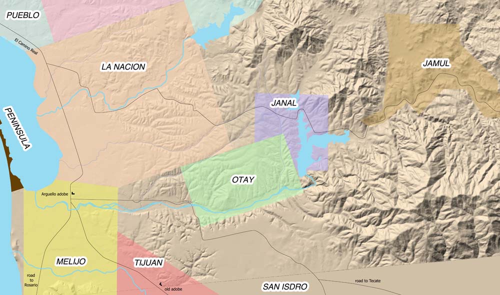
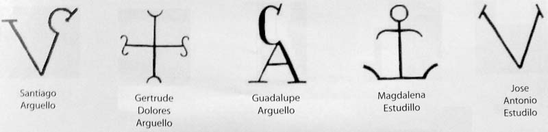
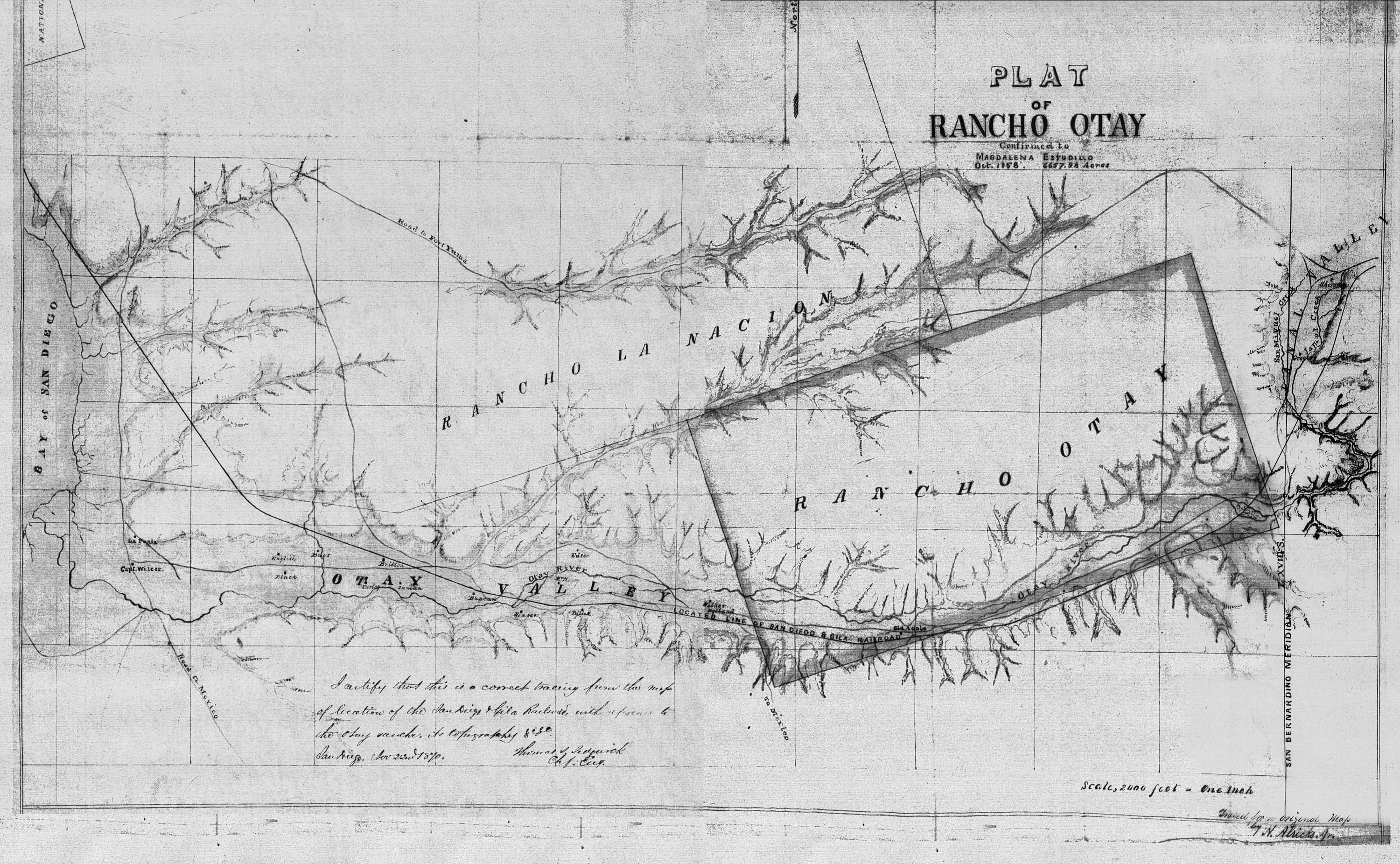
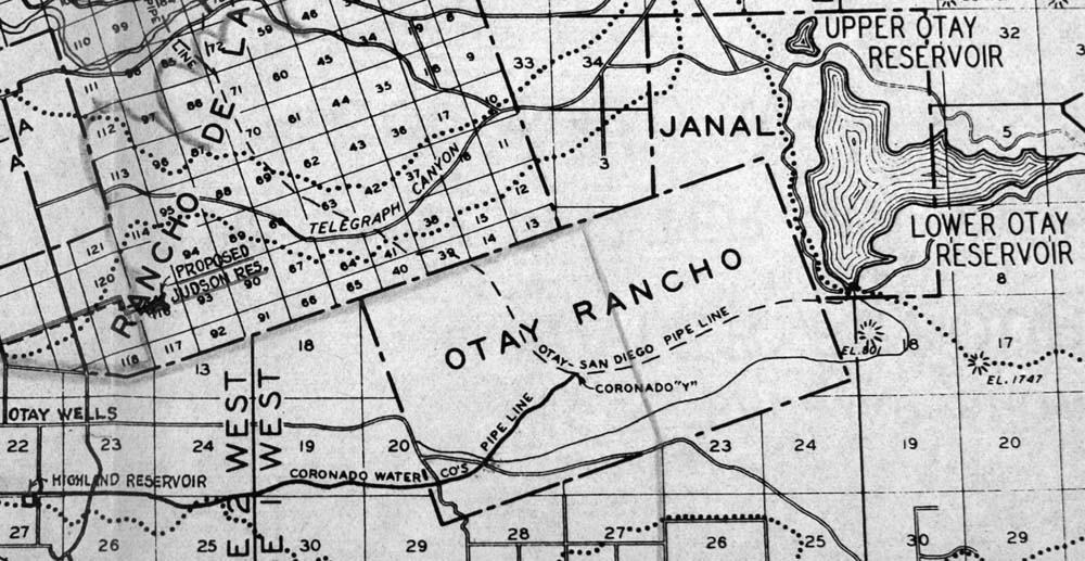
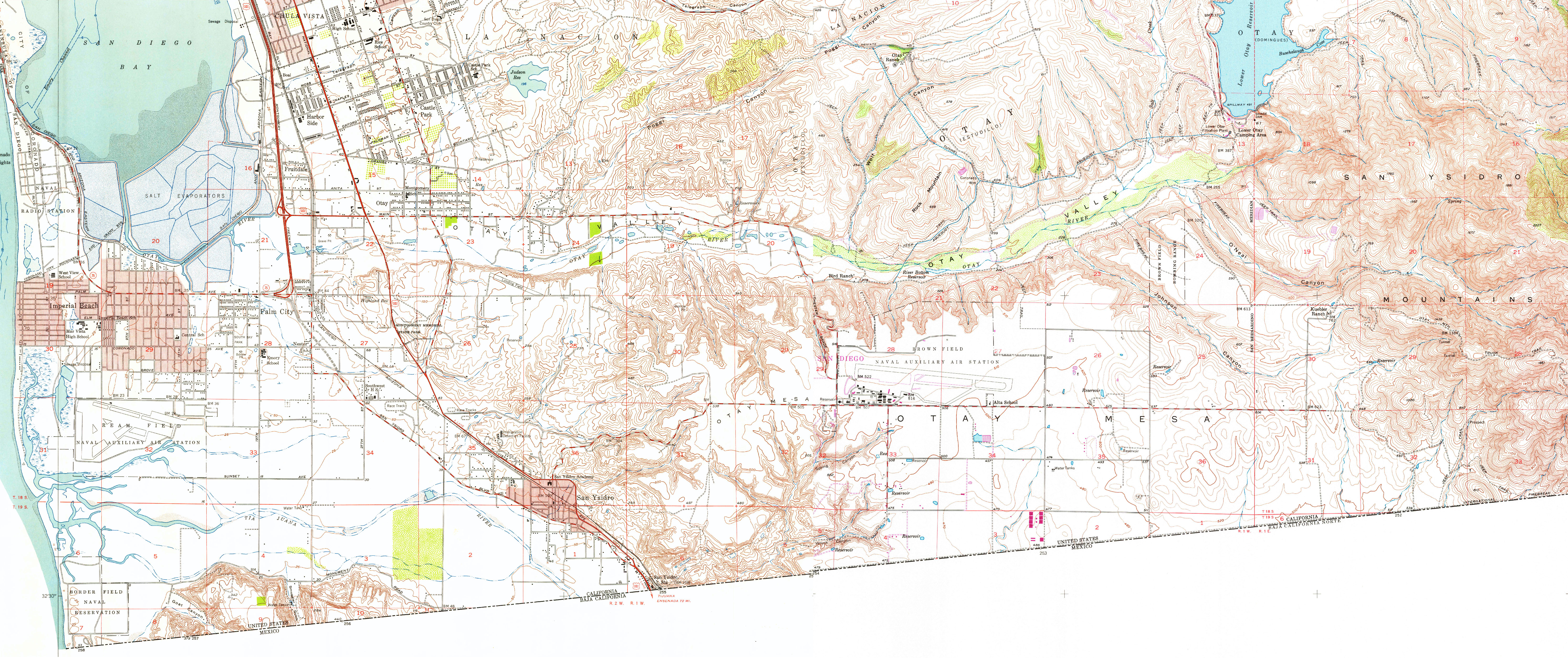
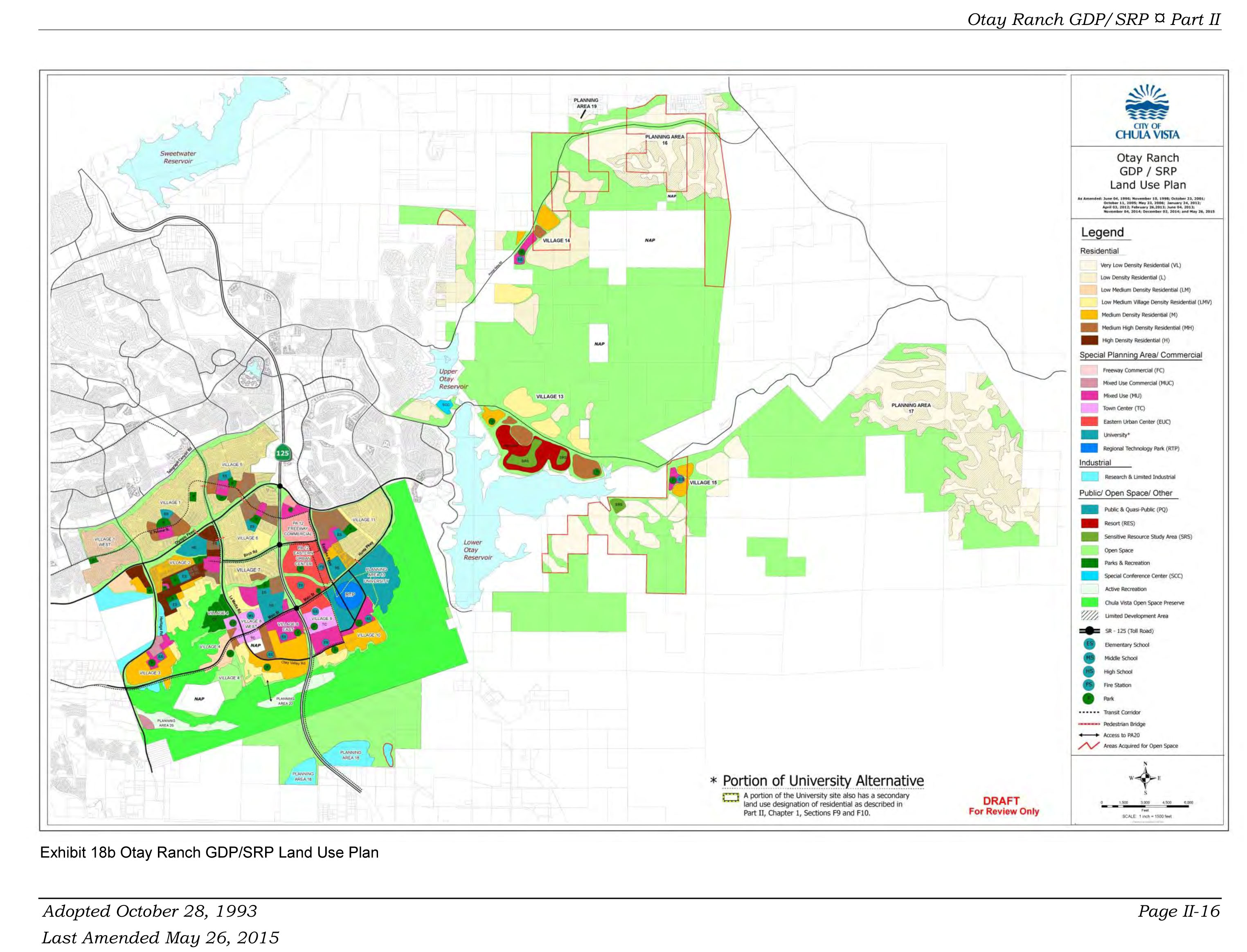
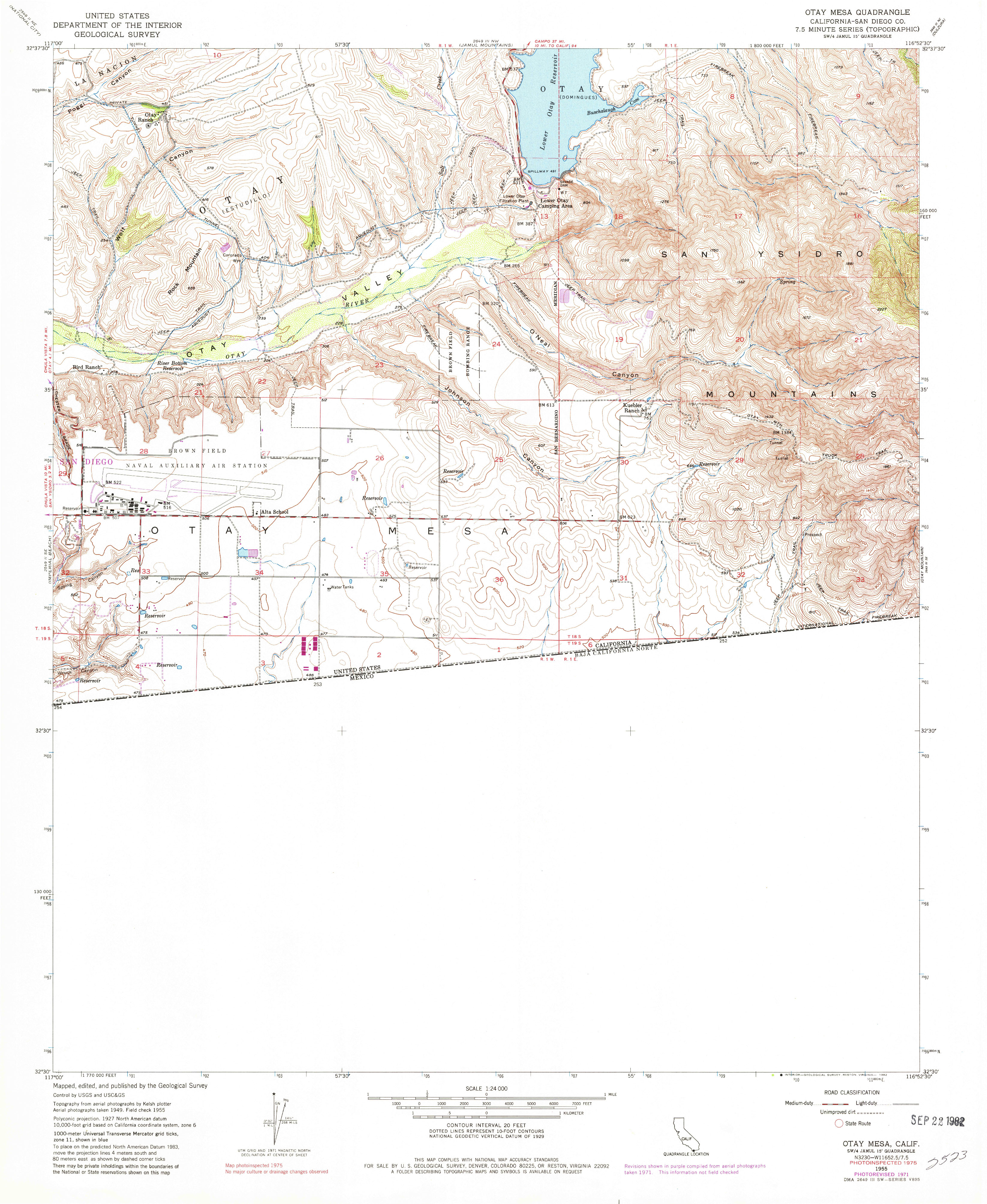
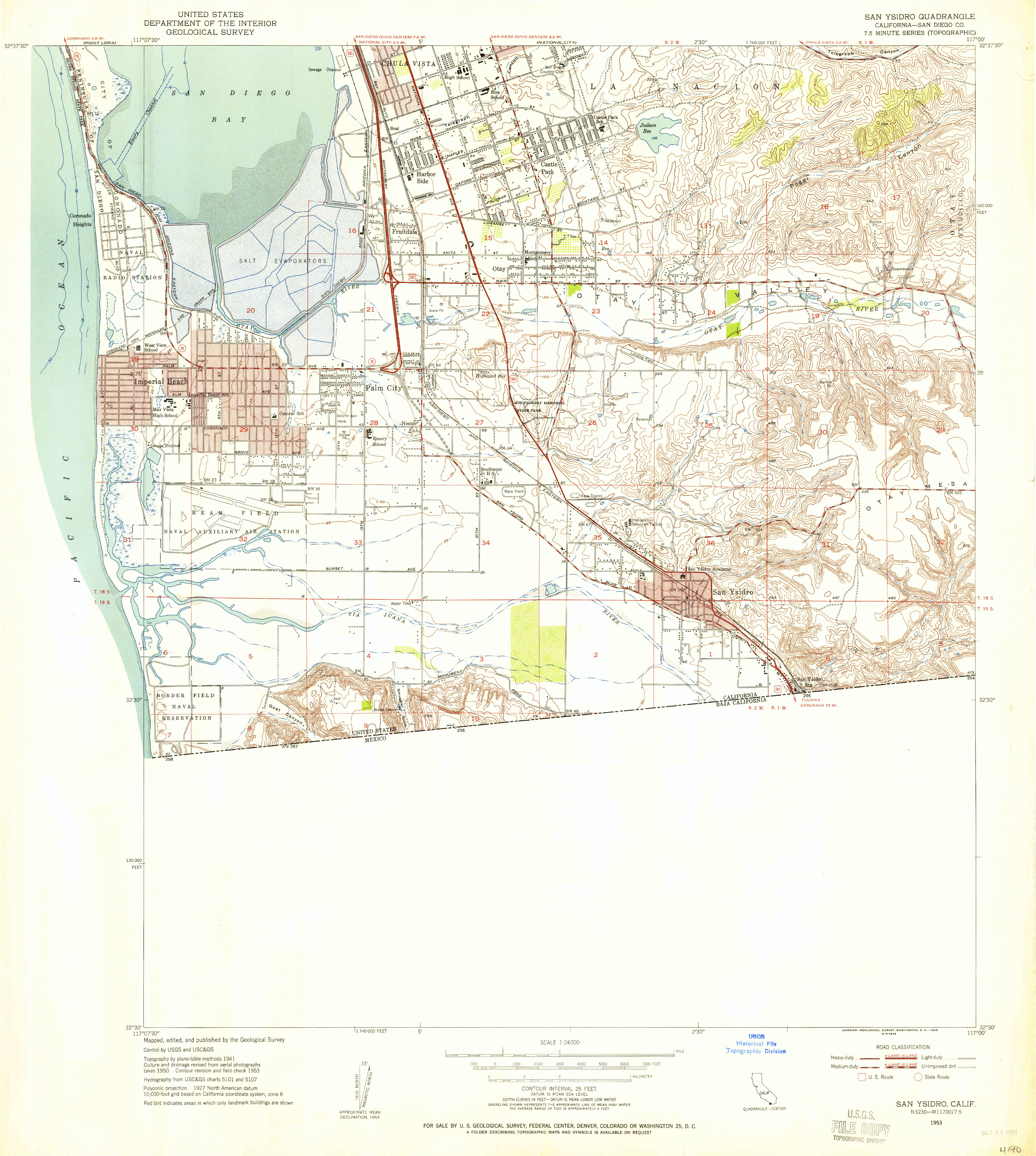